
On April 20, 2010, the Deepwater Horizon Drilling Platform exploded and sank, causing an enormous oil spill in the Gulf of Mexico. U.S. Geological Survey field offices responded immediately by organizing teams to take pre-spill sediment and water samples in order to establish a baseline survey.
Images
Images
Filter Total Items: 9448
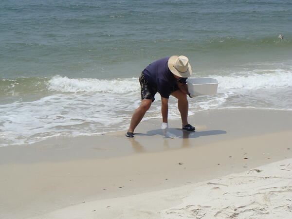
Sand Sampling
On April 20, 2010, the Deepwater Horizon Drilling Platform exploded and sank, causing an enormous oil spill in the Gulf of Mexico. U.S. Geological Survey field offices responded immediately by organizing teams to take pre-spill sediment and water samples in order to establish a baseline survey.
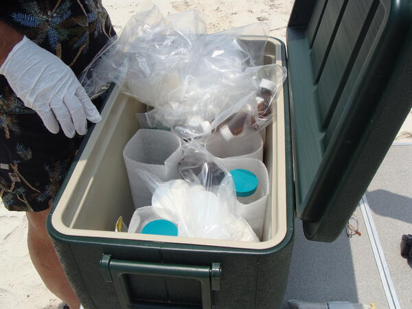
Sample Containers
On April 20, 2010, the Deepwater Horizon Drilling Platform exploded and sank, causing an enormous oil spill in the Gulf of Mexico. U.S. Geological Survey field offices responded immediately by organizing teams to take pre-spill sediment and water samples in order to establish a baseline survey.
On April 20, 2010, the Deepwater Horizon Drilling Platform exploded and sank, causing an enormous oil spill in the Gulf of Mexico. U.S. Geological Survey field offices responded immediately by organizing teams to take pre-spill sediment and water samples in order to establish a baseline survey.
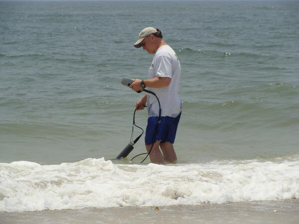
Water Sampling
On April 20, 2010, the Deepwater Horizon Drilling Platform exploded and sank, causing an enormous oil spill in the Gulf of Mexico. U.S. Geological Survey field offices responded immediately by organizing teams to take pre-spill sediment and water samples in order to establish a baseline survey.
On April 20, 2010, the Deepwater Horizon Drilling Platform exploded and sank, causing an enormous oil spill in the Gulf of Mexico. U.S. Geological Survey field offices responded immediately by organizing teams to take pre-spill sediment and water samples in order to establish a baseline survey.

Flows Moving Through Kilauea Viewing Area
A closer view of the recent flows working their way down the road and through the trees. The viewing area has been moved back once again due to its proximity to the lava flows and potential fire hazards.
A closer view of the recent flows working their way down the road and through the trees. The viewing area has been moved back once again due to its proximity to the lava flows and potential fire hazards.
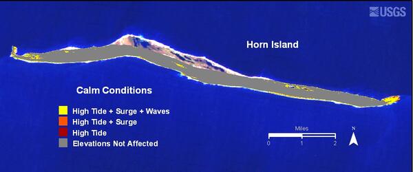
Modeled Scenarios--Calm Weather: Horn Island
Areas likely to be inundated or overwashed.
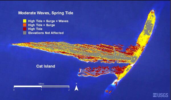
Modeled Scenarios--Moderate Weather: Cat Island
Areas likely to be inundated or overwashed.
Tracking Radio-Tagged Yellow-Rumped Warbler
Dave Slager (Ohio State Univ.) tracks a radio-tagged yellow-rumped warbler to determine habitat use and length of stay during migration stopover at Trempealeau National Wildlife Refuge. This was a collaborative project involving USGS, USFWS and Ohio State Univ.
Dave Slager (Ohio State Univ.) tracks a radio-tagged yellow-rumped warbler to determine habitat use and length of stay during migration stopover at Trempealeau National Wildlife Refuge. This was a collaborative project involving USGS, USFWS and Ohio State Univ.

Secretary Salazar Takes First Hand Look at Oil Spill Response
Secretary Salazar Takes First Hand Look at Oil Spill ResponseDuring his visit to Port Fourchon this morning, Secretary of the Interior Ken Salazar is briefed by Ron Ferguson, BP's Gulf of Mexico Shore Base coordinator, on the 40-foot metal containment structure that is being transported to the site of the leak and deployed to the seabed during the next 48 hours to cover the largest leak at the end of the broken riser pipe.
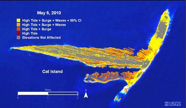
Cat Island Inundation Map
Areas likely to be inundated or overwashed during expected tide, surge, and wave conditions for May 5, 2010.
Areas likely to be inundated or overwashed during expected tide, surge, and wave conditions for May 5, 2010.

Pembina River
Pembina River in May at Neche, North Dakota.
Pembina River in May at Neche, North Dakota.

Petit Bois Island Inundation Map
Areas likely to be inundated or overwashed during expected tide, surge, and wave conditions for May 5, 2010.
Areas likely to be inundated or overwashed during expected tide, surge, and wave conditions for May 5, 2010.

Oil Spill in the Gulf of America- Landsat 7
On April 20, 2010, an explosion at an oil well in the Gulf of America resulted in a major oil spill. Since then, emergency response efforts have been underway to contain the growing oil slick before it reaches the southern coast of the United States. Landsat imagery, acquired by the U.S. Geological Survey on May 1 shows the extent of the oil slick.
On April 20, 2010, an explosion at an oil well in the Gulf of America resulted in a major oil spill. Since then, emergency response efforts have been underway to contain the growing oil slick before it reaches the southern coast of the United States. Landsat imagery, acquired by the U.S. Geological Survey on May 1 shows the extent of the oil slick.

Bumblebee Gecko from Papua New Guinea
The Bumblebee Gecko (Nactus kunan), from Papua New Guinea was discovered in 2010, and described as a new species in 2012. The yellow and black gecko is about 5 inches long.
The Bumblebee Gecko (Nactus kunan), from Papua New Guinea was discovered in 2010, and described as a new species in 2012. The yellow and black gecko is about 5 inches long.

Bumblebee Gecko from Papua New Guinea
The Bumblebee Gecko (Nactus kunan), from Papua New Guinea was discovered in 2010, and described as a new species in 2012.
The Bumblebee Gecko (Nactus kunan), from Papua New Guinea was discovered in 2010, and described as a new species in 2012.

Bumblebee Gecko from Papua New Guinea
The Bumblebee Gecko (Nactus kunan), from Papua New Guinea was discovered in 2010, and described as a new species in 2012. The yellow and black gecko is about 5 inches long.
The Bumblebee Gecko (Nactus kunan), from Papua New Guinea was discovered in 2010, and described as a new species in 2012. The yellow and black gecko is about 5 inches long.

Cannonball River
The Cannonball River in the spring at Breien, ND.
The Cannonball River in the spring at Breien, ND.

Northern Waterthrush
Captured and banded Northern Waterthrush that was radio-tagged as part of a radio telemetry project studying habitat use and length of stay during migration stopover. This was a collaborative project involving USGS, USFWS and Ohio State Univ.
Captured and banded Northern Waterthrush that was radio-tagged as part of a radio telemetry project studying habitat use and length of stay during migration stopover. This was a collaborative project involving USGS, USFWS and Ohio State Univ.

Cannonball River
Cannonball River at Breien, ND.
Cannonball River at Breien, ND.

Aerial Photo of Kilauea Lava Flow
Distant view looking north at the active flow as it crossing the coastal plain and approaches the ocean. Houses in the Kalapana Gardens subdivision are visible to the right. The lava tube feeding lava to the flow front is delineated by the points of fume at upper left.
Distant view looking north at the active flow as it crossing the coastal plain and approaches the ocean. Houses in the Kalapana Gardens subdivision are visible to the right. The lava tube feeding lava to the flow front is delineated by the points of fume at upper left.

Kilauea Lava Flow
View looking south at the currently active flow crossing the coastal plain west of Kalapana. The new flow is the silvery lava crossing the photo from lower right to top center where the flow front is burning vegetation. The end of Hwy 130 is visible at upper left.
View looking south at the currently active flow crossing the coastal plain west of Kalapana. The new flow is the silvery lava crossing the photo from lower right to top center where the flow front is burning vegetation. The end of Hwy 130 is visible at upper left.