
Bombay Beach Barnacle Bar Salton Sea, California.
Images
Images
Filter Total Items: 9448

Bombay Beach Barnacle Bar
Bombay Beach Barnacle Bar Salton Sea, California.

Receding Shoreline
Receding shoreline on the east side of the Salton Sea, California.
Receding shoreline on the east side of the Salton Sea, California.

Composite image of Kilauea viewing area
This composite image overlays a thermal image on a normal photograph, and shows the flow field in the vicinity of the County viewing area, at the end of the Kalapana access road. Recent flows, from the past few weeks, show up as light red, whereas the currently active breakouts are yellow and white.
This composite image overlays a thermal image on a normal photograph, and shows the flow field in the vicinity of the County viewing area, at the end of the Kalapana access road. Recent flows, from the past few weeks, show up as light red, whereas the currently active breakouts are yellow and white.

Ice Out on Yukon River, Pilot Station, Alaska
Panoramic image of ice break up on the Yukon River at Pilot Station, Alaska.
Panoramic image of ice break up on the Yukon River at Pilot Station, Alaska.

Red River of the North at Fargo ND
The Red River of the North at Fargo, North Dakota on May 21, 2010.
The Red River of the North at Fargo, North Dakota on May 21, 2010.

Thermal image of Kilauea viewing area
A closer view of the County viewing area, looking northeast. Again, the thermal image is shown together with a normal photograph. Recently emplaced flows, from the past several weeks, are light red (center of image). The currently active breakouts, just 250 yards northwest of the road, show up as white and yellow.
A closer view of the County viewing area, looking northeast. Again, the thermal image is shown together with a normal photograph. Recently emplaced flows, from the past several weeks, are light red (center of image). The currently active breakouts, just 250 yards northwest of the road, show up as white and yellow.

Aerial coastline of Kilauea
An aerial photograph looking west along the coastline of the current flow field. The Ki entry continues to produce a small plume, which is distributed along the newly formed delta. The color change in the ocean near the entry is due to the wave erosion of material from the delta and the lava itself.
An aerial photograph looking west along the coastline of the current flow field. The Ki entry continues to produce a small plume, which is distributed along the newly formed delta. The color change in the ocean near the entry is due to the wave erosion of material from the delta and the lava itself.

Ice Out on Yukon River, Pilot Station, Alaska
Spring breakup on May 21 on the Yukon River at Pilot Station, Alaska.
Spring breakup on May 21 on the Yukon River at Pilot Station, Alaska.
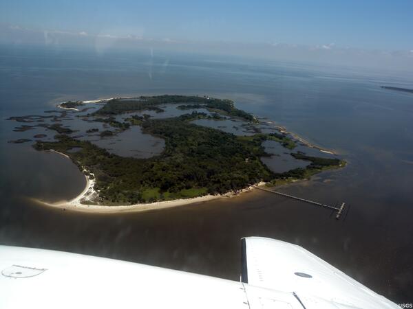
Atsena Otie Key Island
Atsena Otie Key is one of thirteen islands on Florida's Gulf Coast that make up Cedar Keys National Wildlife Refuge. Nearby waters support a multi-million dollar clam-farming industry. USGS documented pre-oil coastal conditions near the Refuge with baseline petrochemical measurements and aerial photography.
Atsena Otie Key is one of thirteen islands on Florida's Gulf Coast that make up Cedar Keys National Wildlife Refuge. Nearby waters support a multi-million dollar clam-farming industry. USGS documented pre-oil coastal conditions near the Refuge with baseline petrochemical measurements and aerial photography.
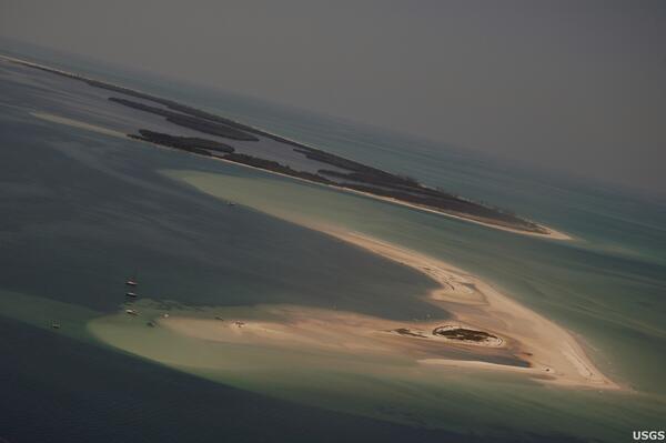
Anclote Key Sand Bar
This USGS aerial photograph shows the white sheen of a sand bar just north of Anclote Key, Florida. Accessible only by boat, Anclote Key is split between a State Park and National Wildlife Refuge.
This USGS aerial photograph shows the white sheen of a sand bar just north of Anclote Key, Florida. Accessible only by boat, Anclote Key is split between a State Park and National Wildlife Refuge.
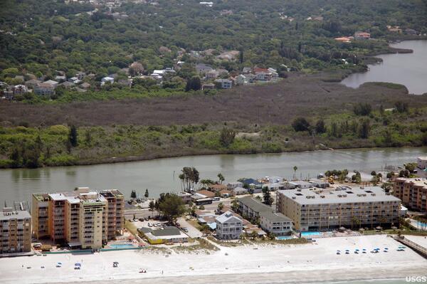
Assessing Potential Impacts on Vegetation
Florida's mangrove forests were hard hit by the uncommonly cold temperatures in January, 2010. Here, a dull brown swath of freeze-damaged mangroves cuts across the photograph, offering a stark contrast with green vegetation lining the nearby Intracoastal Waterway.
Florida's mangrove forests were hard hit by the uncommonly cold temperatures in January, 2010. Here, a dull brown swath of freeze-damaged mangroves cuts across the photograph, offering a stark contrast with green vegetation lining the nearby Intracoastal Waterway.

Mangroves Killed by Hurricane Wilma in Everglades National Park
Mangroves Killed by Hurricane Wilma in Everglades National ParkIn this picture of Shark Island, Everglades National Park, you can see numerous mangroves killed by high winds and storm surge from Hurricane Wilma (2005).
Mangroves Killed by Hurricane Wilma in Everglades National Park
Mangroves Killed by Hurricane Wilma in Everglades National ParkIn this picture of Shark Island, Everglades National Park, you can see numerous mangroves killed by high winds and storm surge from Hurricane Wilma (2005).
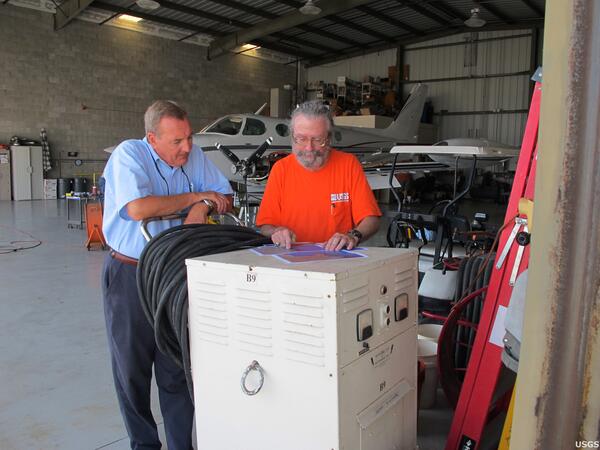
Pre-Oil Reconnaissance Flight
Altogether, flight paths on all of the USGS pre-oil reconnaissance flights covered parts of 11 National Wildlife Refuges, two units of the National Park Service, and numerous State of Florida Parks and Aquatic Preserves. Here, USGS ecologist Tom J. Smith III briefs the pilot on an intended flight path along Florida's west coast.
Altogether, flight paths on all of the USGS pre-oil reconnaissance flights covered parts of 11 National Wildlife Refuges, two units of the National Park Service, and numerous State of Florida Parks and Aquatic Preserves. Here, USGS ecologist Tom J. Smith III briefs the pilot on an intended flight path along Florida's west coast.
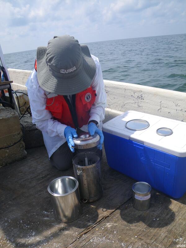
Assessing Pre-Oil Baseline Levels
To assess pre-oil baseline levels of petrochemicals in the waters off Florida's coastline, USGS scientists deployed semi-permeable membrane devices (SPMDs) at 18 locations around Florida in advance of oil landfall from the Deepwater Horizon incident.
To assess pre-oil baseline levels of petrochemicals in the waters off Florida's coastline, USGS scientists deployed semi-permeable membrane devices (SPMDs) at 18 locations around Florida in advance of oil landfall from the Deepwater Horizon incident.
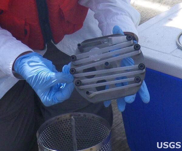
Fatbag Membrane
Although oil and water do not normally mix, oil contaminants in waterways can be measured using a special membrane nicknamed a "fatbag." The fatbags absorb many fat-soluble chemicals from the water at a known rate, so they can be used to estimate the concentration of such chemicals.
Although oil and water do not normally mix, oil contaminants in waterways can be measured using a special membrane nicknamed a "fatbag." The fatbags absorb many fat-soluble chemicals from the water at a known rate, so they can be used to estimate the concentration of such chemicals.
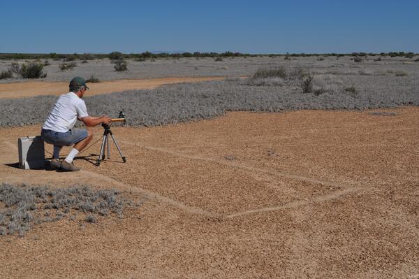
Arid Soils
Studying arid soils for remote sensing. Jim Crowley taking spectral measurements with a field spectrometer.
Studying arid soils for remote sensing. Jim Crowley taking spectral measurements with a field spectrometer.
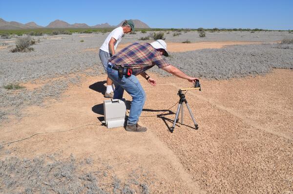
Arid Soils
Studying arid soils for remote sensing. Jim Crowley and John Mars taking spectral measurements of arid soil with a field spectrometer.
Studying arid soils for remote sensing. Jim Crowley and John Mars taking spectral measurements of arid soil with a field spectrometer.
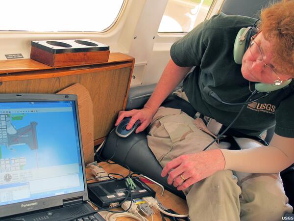
Gear Preparation
USGS geologist Karen Morgan prepares gear that records the flight path so that its GPS coordinates can be synchronized with the camera. The resulting images are tagged with GPS coordinates.
USGS geologist Karen Morgan prepares gear that records the flight path so that its GPS coordinates can be synchronized with the camera. The resulting images are tagged with GPS coordinates.

Fathead Minnow
Fathead minnow
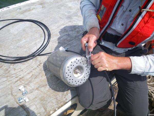
Assessing Pre-Oil Baseline Levels
A USGS researcher deploys an SPMD near Cedar Key, Florida in advance of oil landfall from the Deepwater Horizon Spill. After remaining at a sampling site for up to 28 days, the special membrane inside the SPMD is retrieved and sent to a laboratory for analysis.
A USGS researcher deploys an SPMD near Cedar Key, Florida in advance of oil landfall from the Deepwater Horizon Spill. After remaining at a sampling site for up to 28 days, the special membrane inside the SPMD is retrieved and sent to a laboratory for analysis.

Arid Soils
Taking measurements of arid soil with a field spectrometer.
Taking measurements of arid soil with a field spectrometer.