
Walruses in the Chukchi Sea during a tagging survey onboard the Norseman II in June 2010.
Images
Images
Filter Total Items: 9447

Single Walrus From The Side View
Walruses in the Chukchi Sea during a tagging survey onboard the Norseman II in June 2010.

Up Close: LA Barred Owl
This Barred Owl was fearless in Baton Rouge, LA
This Barred Owl was fearless in Baton Rouge, LA

Bridges on the Little Missouri River
Little Missouri River at Marmarth, North Dakota, flowing under the railroad and highway bridges, streamflow 260 cubic feet per second, gage height 2.38 feet.
Little Missouri River at Marmarth, North Dakota, flowing under the railroad and highway bridges, streamflow 260 cubic feet per second, gage height 2.38 feet.

Deepwater Horizon Controlled Oil Burn
OFF THE LOUISIANA COAST — A controlled burn of oil from the Deepwater Horizon/BP oil spill sends towers of fire hundreds of feet into the air over the Gulf of Mexico. U.S. Coast Guard Photo by Petty Officer First Class John Masson.
OFF THE LOUISIANA COAST — A controlled burn of oil from the Deepwater Horizon/BP oil spill sends towers of fire hundreds of feet into the air over the Gulf of Mexico. U.S. Coast Guard Photo by Petty Officer First Class John Masson.
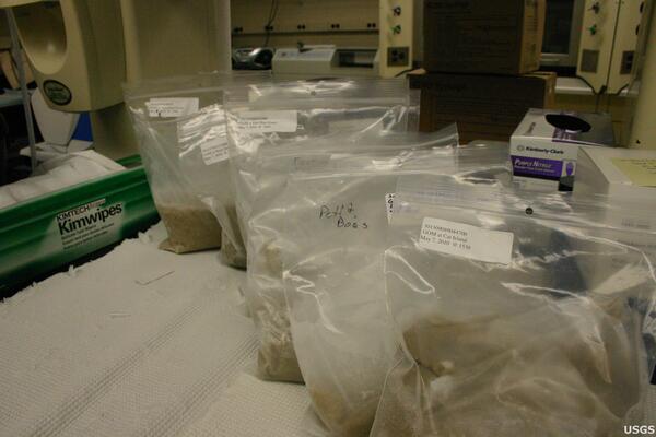
Samples for Analysis
Samples of benthic infauna taken from the beaches of Louisiana's barrier islands await analysis at the USGS Southeast Ecological Science Center in Gainesville, Florida.
Samples of benthic infauna taken from the beaches of Louisiana's barrier islands await analysis at the USGS Southeast Ecological Science Center in Gainesville, Florida.

Green River
Green River near New Hradec, North Dakota, streamflow 3.55 cubic feet per second.
Green River near New Hradec, North Dakota, streamflow 3.55 cubic feet per second.

Storm Approaching Green River
Sky is dark in the background because a storm moving in to Green River Basin. Taken at USGS streamgage near New Hradec, North Dakota, streamflow 3.55 cubic feet per second.
Sky is dark in the background because a storm moving in to Green River Basin. Taken at USGS streamgage near New Hradec, North Dakota, streamflow 3.55 cubic feet per second.

Maple River Dam
Control chute, Maple River at Maple River Dam, near Sheldon, ND, streamflow 641 cubic feet per second.
Control chute, Maple River at Maple River Dam, near Sheldon, ND, streamflow 641 cubic feet per second.

Hills along the Missouri River Valley
View near a groundwater well site, looking at Missouri River, near Huff, North Dakota.
View near a groundwater well site, looking at Missouri River, near Huff, North Dakota.

Hillside in the Missouri River Valley
View from a groundwater well site. Missouri River in the distance, near Huff, North Dakota.
View from a groundwater well site. Missouri River in the distance, near Huff, North Dakota.

Caspian Tern
Birds found in and around the Salton Sea, California.
Birds found in and around the Salton Sea, California.

Water Flowing over Weir
Water flowing over weir on Souris River near Foxholm, North Dakota, streamflow 8.45 cubic feet per second.
Water flowing over weir on Souris River near Foxholm, North Dakota, streamflow 8.45 cubic feet per second.

Thermal Image of Pu'u 'O'o Pond
"Rootless" lava shields are those built over a lava tube, as opposed to those which develop over the vent. This rootless shield was built over the past week, and hosted a lava pond at its summit. Overflows from the pond cascaded down the steep flanks.
"Rootless" lava shields are those built over a lava tube, as opposed to those which develop over the vent. This rootless shield was built over the past week, and hosted a lava pond at its summit. Overflows from the pond cascaded down the steep flanks.
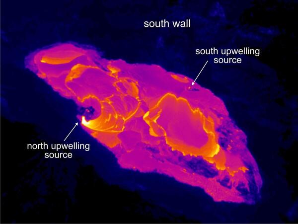
Thermal Image of Pu'u 'O'o Pond
This thermal image shows the lava pond within Pu`u `Ō `ō crater. The view is towards the southeast. The pond is fed from two upwelling sources, one on the south margin of the pond and one on the north margin.
This thermal image shows the lava pond within Pu`u `Ō `ō crater. The view is towards the southeast. The pond is fed from two upwelling sources, one on the south margin of the pond and one on the north margin.
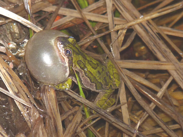
Boreal chorus frog calling on detritus
Source: USGS Northern Rocky Mountain Science Center. Photographer: P.S. Corn. Boreal Chorus Frog, Lily Pond, Larimer County, Colorado. June 2010
Pseudacris maculata - Boreal Chorus Frog
Source: USGS Northern Rocky Mountain Science Center. Photographer: P.S. Corn. Boreal Chorus Frog, Lily Pond, Larimer County, Colorado. June 2010
Pseudacris maculata - Boreal Chorus Frog

Our Great Falls
Great Falls Park in Mclean, VA.
Great Falls Park in Mclean, VA.

Pristine Pacific Sunset
Sunset along the Southern California coast with waves crashing along the rocks.
Sunset along the Southern California coast with waves crashing along the rocks.

Sandy Pacific Sunset
Sunset along a Southern California beach.
Sunset along a Southern California beach.

Caution - Rising Water
Chain of Lakes - Lake Laretta near Lakota, North Dakota, near a former groundwater well site and what used to be a road.
Chain of Lakes - Lake Laretta near Lakota, North Dakota, near a former groundwater well site and what used to be a road.

Water Flowing over Weir
Water flowing over weir on the Souris River near Westhope, North Dakota, streamflow 1,540 cubic feet per second.
Water flowing over weir on the Souris River near Westhope, North Dakota, streamflow 1,540 cubic feet per second.

Bombay Beach Barnacle Bar
Bombay Beach Barnacle Bar Salton Sea, California.
Bombay Beach Barnacle Bar Salton Sea, California.