
This is an aerial view looking south from above Pool 7 of the Upper Mississippi River near Trempealeau, WI. The navigation dam which creates the pool appears slightly below the horizon in the upper left quadrant. Wing dams are evidenced by the rippling water in the river channel as they direct the flow toward the main channel. The complex backwater
Images
Images
Filter Total Items: 9448

Upper Mississippi River, Pool 7
This is an aerial view looking south from above Pool 7 of the Upper Mississippi River near Trempealeau, WI. The navigation dam which creates the pool appears slightly below the horizon in the upper left quadrant. Wing dams are evidenced by the rippling water in the river channel as they direct the flow toward the main channel. The complex backwater

From Bluff to Backwater
This is an aerial view of Pool 7 of the Mississippi River south of Trempealeau, WI. This photo highlights the different habitats for plants and wildlife from the bluffs that parallel the river to its quiet backwaters. Balanced with that is the fact that the Mississippi River is a commercial highway as well as a haven for recreational uses.
This is an aerial view of Pool 7 of the Mississippi River south of Trempealeau, WI. This photo highlights the different habitats for plants and wildlife from the bluffs that parallel the river to its quiet backwaters. Balanced with that is the fact that the Mississippi River is a commercial highway as well as a haven for recreational uses.

North Dakota Sky, Water, and Prairie
View near a groundwater well in North Dakota.
View near a groundwater well in North Dakota.

Honolulu Geomagnetic Observatory
Pacific Tsunami Warning Center building.
Pacific Tsunami Warning Center building.

Instrumentation Array, Beaver Creek Near Michael Lake, Alaska
Instrumentation Array, Beaver Creek Near Michael Lake, AlaskaInstrumentation array with a YSI multiparameter sonde, a dissolved CO2 sensor, and a CDOM sensor.
Instrumentation Array, Beaver Creek Near Michael Lake, Alaska
Instrumentation Array, Beaver Creek Near Michael Lake, AlaskaInstrumentation array with a YSI multiparameter sonde, a dissolved CO2 sensor, and a CDOM sensor.

Instrumentation Array, Beaver Creek Above Victoria Creek, Alaska
Instrumentation Array, Beaver Creek Above Victoria Creek, AlaskaInstrumentation array with a YSI multiparameter sonde, a dissolved CO2 sensor, and a CDOM sensor.
Instrumentation Array, Beaver Creek Above Victoria Creek, Alaska
Instrumentation Array, Beaver Creek Above Victoria Creek, AlaskaInstrumentation array with a YSI multiparameter sonde, a dissolved CO2 sensor, and a CDOM sensor.

Key West National Wildlife Refuge
Mangrove islands in the Key West National Wildlife Refuge provide valuable habitat for nesting birds and sea turtles.
Mangrove islands in the Key West National Wildlife Refuge provide valuable habitat for nesting birds and sea turtles.

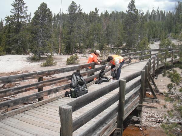
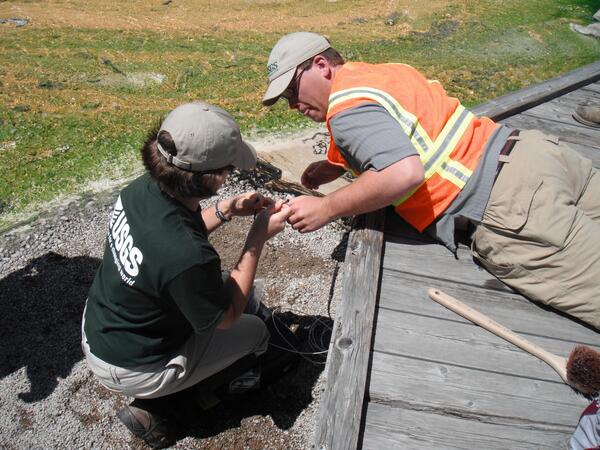
USGS Scientists Installing Temperature Sensor
USGS scientists Laura Clor and Tim Moloney installing a temperature sensor under a public boardwalk in Norris Geyser Basin, Yellowstone National Park.
USGS scientists Laura Clor and Tim Moloney installing a temperature sensor under a public boardwalk in Norris Geyser Basin, Yellowstone National Park.

Yellowstone Temperature Logger
Yellowstone Volcano Observatory temperature logger and radio transmitter installed in a weatherproof case under a public boardwalk in Yellowstone National Park. The white cable leads to a temperature sensor in the water under the rocks. The black cable leads to a radio antenna attached to the side of the boardwalk.
Yellowstone Volcano Observatory temperature logger and radio transmitter installed in a weatherproof case under a public boardwalk in Yellowstone National Park. The white cable leads to a temperature sensor in the water under the rocks. The black cable leads to a radio antenna attached to the side of the boardwalk.
USGS Scientists Installing Temperature Sensor
USGS scientists Laura Clor and Tim Moloney installing a temperature sensor under a public boardwalk in Norris Geyser Basin, Yellowstone National Park.
USGS scientists Laura Clor and Tim Moloney installing a temperature sensor under a public boardwalk in Norris Geyser Basin, Yellowstone National Park.

Smoke From Schultz Pass Forest Fire, Flagstaff, Arizona, June 20, 2010
Smoke From Schultz Pass Forest Fire, Flagstaff, Arizona, June 20, 2010Panorama (180 degree field of view) photograph of smoke rising from the Schultz Pass fire near Flagstaff, Arizona, at 1:34 p.m. on its day of ignition, June 20, 2010. Over the following 10 days, the fire burned an estimated 15,075 acres, or more than 23 square miles of northern Arizona forest, and cost more than \$8.6 million to fight.

Surface Fractures Along Fault
Photograph of surface fractures along fault south of Pinto Wash; view to the northeast.
Photograph of surface fractures along fault south of Pinto Wash; view to the northeast.

Aerial View of Auwahi Dryland Forest Restoration Project
Aerial View of Auwahi Dryland Forest Restoration ProjectThe dark-green, rectangular, reforested area of the Auwahi dryland forest as seen from above with surrounding grassland.
Aerial View of Auwahi Dryland Forest Restoration Project
Aerial View of Auwahi Dryland Forest Restoration ProjectThe dark-green, rectangular, reforested area of the Auwahi dryland forest as seen from above with surrounding grassland.

Fractures on Ocotillo Fault
Vertical surface fractures along Ocotillo Fault. Faulting here is associated with the nearby Mw5.7 aftershock of June 14, 2010. Tape measure for scale.
Vertical surface fractures along Ocotillo Fault. Faulting here is associated with the nearby Mw5.7 aftershock of June 14, 2010. Tape measure for scale.

Cannonball River
Looking west at the Cannonball River at Breien, North Dakota.
Looking west at the Cannonball River at Breien, North Dakota.

Drought Effect
The white colored rock (approximately 100ft high) shows the drop in the water level of Lake Mead as a result of the ongoing 10-year drought along the Colorado River.
The white colored rock (approximately 100ft high) shows the drop in the water level of Lake Mead as a result of the ongoing 10-year drought along the Colorado River.

Quillayute River Estuary in Bloom
Quillayute River near La Push, Washington. Looking downstream from Mora Road toward the river mouth and Pacific Ocean, with James Island in the distance.
Quillayute River near La Push, Washington. Looking downstream from Mora Road toward the river mouth and Pacific Ocean, with James Island in the distance.

Walrus In The Water Up Close
Walruses in the Chukchi Sea during a tagging survey onboard the Norseman II in June 2010.
Walruses in the Chukchi Sea during a tagging survey onboard the Norseman II in June 2010.

Walrus Female And Calf Up Close From The Side
Walruses in the Chukchi Sea during a tagging survey onboard the Norseman II in June 2010.
Walruses in the Chukchi Sea during a tagging survey onboard the Norseman II in June 2010.

Walrus Female And Calf On An Ice Floe
Walruses in the Chukchi Sea during a tagging survey onboard the Norseman II in June 2010.
Walruses in the Chukchi Sea during a tagging survey onboard the Norseman II in June 2010.