
Zebra Mussel, Lake Huron specimens.
Images
Images
Filter Total Items: 9452

Zebra Mussels
Zebra Mussel, Lake Huron specimens.

'Akiapōlā'au
Endangered Hawai'i forest bird, 'Akiapōlā‘au (Hemignathus munroi).
Endangered Hawai'i forest bird, 'Akiapōlā‘au (Hemignathus munroi).

Zebra Mussels
Zebra Mussel, Lake Huron specimens.
Zebra Mussel, Lake Huron specimens.

'Akepa
Endangered Hawaiʻi forest bird, 'Akepa (Loxops coccineus) (male).
Endangered Hawaiʻi forest bird, 'Akepa (Loxops coccineus) (male).

Hawai'i Creeper
Endangered forest bird, Hawai'i Creeper (Oreomystis mana).
Endangered forest bird, Hawai'i Creeper (Oreomystis mana).

Pu’u ‘Ō’ō Lava Lake
View of the lava lake found inside the crater in Pu’u ‘Ō’ō cinder cone.
View of the lava lake found inside the crater in Pu’u ‘Ō’ō cinder cone.

Valley of Ten Thousand Smokes, Alaska
View southeast from Overlook Cabin looking over the Valley of Ten Thousand Smokes. The pyroclastic and ash deposits that fill the valley remain nearly vegetation-free more than 100 years after the 1912 Novarupta-Katmai eruption.
View southeast from Overlook Cabin looking over the Valley of Ten Thousand Smokes. The pyroclastic and ash deposits that fill the valley remain nearly vegetation-free more than 100 years after the 1912 Novarupta-Katmai eruption.

Cinder Cones on Mauna Kea
Cinder cones at the summit of Mauna Kea. Mauna Kea is a dormant shield volcano on the north end of Hawaii Island. Astronomical observatories in the foreground.
Cinder cones at the summit of Mauna Kea. Mauna Kea is a dormant shield volcano on the north end of Hawaii Island. Astronomical observatories in the foreground.

Pu’u ‘Ō’ō Crater
View of the crater at the top of the Pu’u ‘Ō’ō cinder cone prior to the appearance of collapse pits in the flank of the cone.
View of the crater at the top of the Pu’u ‘Ō’ō cinder cone prior to the appearance of collapse pits in the flank of the cone.

Sampling a Fumarole
USGS geochemist Cathy Janik (left) and Iceland Geosurvey chemist Jón Örn Bjarnason (right) collect a gas sample from a fumarole in Lassen Volcanic National Park.
USGS geochemist Cathy Janik (left) and Iceland Geosurvey chemist Jón Örn Bjarnason (right) collect a gas sample from a fumarole in Lassen Volcanic National Park.
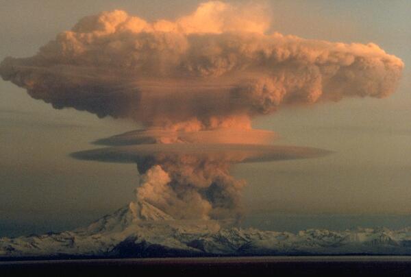
Redoubt Volcano
Ascending eruption cloud from Redoubt Volcano as viewed to the west from the Kenai Peninsula. The mushroom-shaped plume rose from avalanches of hot debris (pyroclastic flows) that cascaded down the north flank of the volcano. A smaller, white steam plume rises from the summit crater.
Ascending eruption cloud from Redoubt Volcano as viewed to the west from the Kenai Peninsula. The mushroom-shaped plume rose from avalanches of hot debris (pyroclastic flows) that cascaded down the north flank of the volcano. A smaller, white steam plume rises from the summit crater.

Stringing Nets to Catch Mongooses
For a behavioral study of Crossarchus obscurus, the long-nosed cusimanse, in Tiwai Island Wildlife Sanctuary, Sierra Leone, West Africa, fishing nets were the most successful method of capturing an entire group of these mongooses, compared to baited live-traps and thatch fences (which channeled animals into live traps, and which were moderately successful).
For a behavioral study of Crossarchus obscurus, the long-nosed cusimanse, in Tiwai Island Wildlife Sanctuary, Sierra Leone, West Africa, fishing nets were the most successful method of capturing an entire group of these mongooses, compared to baited live-traps and thatch fences (which channeled animals into live traps, and which were moderately successful).

Lava tube sea entry on Hawai'i Island
Lava flows from a lava tube into the sea near Kupapau Point on Hawai'i Island. From the Kilauea East Rift Zone (ERZ) eruption, November 27, 1989. Episode 48 of the Kupapau Lava Flow.
Lava flows from a lava tube into the sea near Kupapau Point on Hawai'i Island. From the Kilauea East Rift Zone (ERZ) eruption, November 27, 1989. Episode 48 of the Kupapau Lava Flow.

Kilauea lava flows from a tube into the sea, November 27, 1989
Kilauea lava flows from a tube into the sea, November 27, 1989Lava flows from a lava tube into the sea near Kupapau Point on 11/27/1989. From the Kilauea East Rift Zone (ERZ) eruption, eruption pisode 48, Kupapau lava flow. Hawai'i Island.

Damaged Building
A downtown building at the corner of Alice and 13th Streets lost part of its unreinforced facade and brick masonry.
A downtown building at the corner of Alice and 13th Streets lost part of its unreinforced facade and brick masonry.

Pahoehoe from Kilauea eruption, 1989
Pahoehoe ropes form in the Wahaula Lava Flow across from Wahaula Visitor Center on Hawai'i Island during the Kilauea East Rift Zone (ERZ) eruption on 6/15/89.
Pahoehoe ropes form in the Wahaula Lava Flow across from Wahaula Visitor Center on Hawai'i Island during the Kilauea East Rift Zone (ERZ) eruption on 6/15/89.

Mount Rainier seen from Puyallup, Washington

Cliff Palace, Mesa Verde National Park, Colorado - 1989
Cliff Palace, Mesa Verde National Park, Colorado - 1989The kivas, which were unexcavated by Nordenskiöld, are now exposed. Fewkes did considerable repair of the tower, kivas, and other structures when he excavated the ruin in 1909. Paths for visitors have been added to facilitate access. (Bill Howard).

China's Qaidam Basin Landscape Similar with Mars
Geologist, sedimentation expert and Mars Science Laboratory team member David Rubin of the USGS Pacific Coastal and Marine Science Center investigates longitudinal dunes in China's Qaidam Basin. He comments: "The landscape has some similarity with Mars: almost total lack of vegetation and wind-formed landscape."
Geologist, sedimentation expert and Mars Science Laboratory team member David Rubin of the USGS Pacific Coastal and Marine Science Center investigates longitudinal dunes in China's Qaidam Basin. He comments: "The landscape has some similarity with Mars: almost total lack of vegetation and wind-formed landscape."
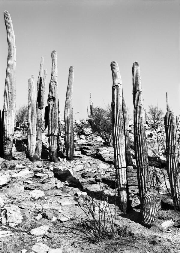
Santa Catalina Highway, near Tucson, Southern Arizona - 1987
Santa Catalina Highway, near Tucson, Southern Arizona - 1987This image was taken above the Santa Catalina Highway near mile 2.8 a few months after a fire burned across a south-facing slope. The saguaros are showing the effects of being scorched but are still standing. (Raymond M. Turner).

Lava flow enters Queens Bath, Kilauea Volcano, 1987
Lava flow enters Queens Bath, Kilauea Volcano, 1987Bystanders watch steam rising from Queens Bath as lava flow enters the water. Lava overran Highway 130 at 0748 Hawaii Standard Time on the same morning at the western margin of the Kapa'ahu flow. By the end of the day, Punalu'u heiau was overrun, and Queens Bath was filled with lava.