
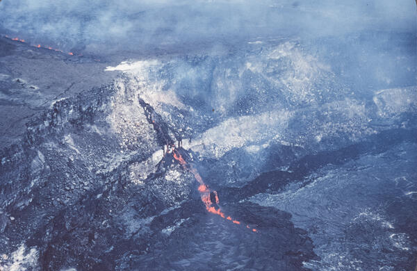
The April 30, 1982, Kaluapele eruption was a short-lived summit event that lasted about 19 hours. Lava erupted from a 3,200-foot-long fissure northeast of Halemaʻumaʻu crater, producing low fountains 15–30 feet high, with bursts up to 160 feet.
Images
Images
Filter Total Items: 9452
April 1982 Kaluapele Eruption
The April 30, 1982, Kaluapele eruption was a short-lived summit event that lasted about 19 hours. Lava erupted from a 3,200-foot-long fissure northeast of Halemaʻumaʻu crater, producing low fountains 15–30 feet high, with bursts up to 160 feet.

Gas Sampling around the Mount St. Helens Dome
USGS geologists gathered samples by hand from vents on the dome and crater floor. Additionally, sulfur dioxide gas was measured from a specially equipped airplane before, during, and after eruptions to determine "emission rates" for the volcano.
USGS geologists gathered samples by hand from vents on the dome and crater floor. Additionally, sulfur dioxide gas was measured from a specially equipped airplane before, during, and after eruptions to determine "emission rates" for the volcano.

Winter Park Florida Sinkhole of 1981
Photo 15 of 15: Water level in sinkhole chimney stabilized since the previous day. View to south across the sinhole.
Photo 15 of 15: Water level in sinkhole chimney stabilized since the previous day. View to south across the sinhole.

Winter Park Florida Sinkhole of 1981
Photo 13 of 15: Water level in sinkhole chimney continued to rise. View to east across the sinkhole. (6 p.m.)
Photo 13 of 15: Water level in sinkhole chimney continued to rise. View to east across the sinkhole. (6 p.m.)

Winter Park Florida Sinkhole of 1981
Photo 14 of 15: Remnants of community pool in sinkhole. View to east across the sinkhole.
Photo 14 of 15: Remnants of community pool in sinkhole. View to east across the sinkhole.

Winter Park Florida Sinkhole of 1981
Photo 7 of 15: Cars in a sinkhole. Auto mechanic’s garage starting to collapse into sinkhole. View to south across the sinkhole.
Photo 7 of 15: Cars in a sinkhole. Auto mechanic’s garage starting to collapse into sinkhole. View to south across the sinkhole.

Winter Park Florida Sinkhole of 1981
Photo 4 of 15: House within the sinkhole. View to north across the sinkhole.
Photo 4 of 15: House within the sinkhole. View to north across the sinkhole.

Winter Park Florida Sinkhole of 1981
Photo 9 of 15: Community pool collapsing into sinkhole at. Pool was roughly Olympic-sized and was about half full at the time of collapse. Impressive sounds of the rebar and concrete snapping, then the rush of water. View to north across the sinkhole. (1:30 p.m)
Photo 9 of 15: Community pool collapsing into sinkhole at. Pool was roughly Olympic-sized and was about half full at the time of collapse. Impressive sounds of the rebar and concrete snapping, then the rush of water. View to north across the sinkhole. (1:30 p.m)

Winter Park Florida Sinkhole of 1981
Photo 10 of 15: Sinkhole chimney after pool collapse. View to south across the sinkholne. For a time after the pool collapse and introduction of the pool water into the sinkhole, there was a noticeable increase in slope movement, especially deeper in the sinkhole. The house and building parts broke up further and disappeared.
Photo 10 of 15: Sinkhole chimney after pool collapse. View to south across the sinkholne. For a time after the pool collapse and introduction of the pool water into the sinkhole, there was a noticeable increase in slope movement, especially deeper in the sinkhole. The house and building parts broke up further and disappeared.

Winter Park Florida Sinkhole of 1981
Photo 11 of 15: Intersection of South Denning Drive and West Comstock Ave. Sinkhole is edging close to Denning Drive. One block of Comstock Ave was swallowed. View to south on Denning Drive adjacent to the sinkhole.
Photo 11 of 15: Intersection of South Denning Drive and West Comstock Ave. Sinkhole is edging close to Denning Drive. One block of Comstock Ave was swallowed. View to south on Denning Drive adjacent to the sinkhole.

Winter Park Florida Sinkhole of 1981
Photo 12 of 15: Water level has risen and is now apparent in sinkhole since pool collapse and house swallowed. View to south across the sinkhole. The rising water level is likely a result of the debris plugging the conduit into the Floridan aquifer. Water level is rising to assume a position more consistent with that of the surficial aquifer. (3 p.m.)
Photo 12 of 15: Water level has risen and is now apparent in sinkhole since pool collapse and house swallowed. View to south across the sinkhole. The rising water level is likely a result of the debris plugging the conduit into the Floridan aquifer. Water level is rising to assume a position more consistent with that of the surficial aquifer. (3 p.m.)

Winter Park Florida Sinkhole of 1981
Photo 6 of 15: Sinkhole chimney at approximately 12 noon. View to south across the sinkhole.
Photo 6 of 15: Sinkhole chimney at approximately 12 noon. View to south across the sinkhole.

Winter Park Florida Sinkhole of 1981
Photo 8 of 15: Community pool prior to collapse into the sinkhole. View to north across the sinkhole. (1:30 p.m)
Photo 8 of 15: Community pool prior to collapse into the sinkhole. View to north across the sinkhole. (1:30 p.m)

Winter Park Florida Sinkhole of 1981
This collection is a group of 15 images (digitized slides) showing the sinkhole that opened late in the evening of May 8, 1981 near the intersection of South Denning Drive and West Fairbanks Avenue, Winter Park, Florida, USA.
This collection is a group of 15 images (digitized slides) showing the sinkhole that opened late in the evening of May 8, 1981 near the intersection of South Denning Drive and West Fairbanks Avenue, Winter Park, Florida, USA.

Winter Park Florida Sinkhole of 1981
Photo 2 of 15: Cars and house in a sinkhole. Auto mechanic’s garage intact. View to south across the sinkhole.
Photo 2 of 15: Cars and house in a sinkhole. Auto mechanic’s garage intact. View to south across the sinkhole.

Winter Park Florida Sinkhole of 1981
Photo 3 of 15: Community pool being undercut by a sinkhole. View to west across the sinkhole.
Photo 3 of 15: Community pool being undercut by a sinkhole. View to west across the sinkhole.

Winter Park Florida Sinkhole of 1981
Photo 5 of 15: House in a sinkhole. View to east across the sinkhole.
Photo 5 of 15: House in a sinkhole. View to east across the sinkhole.

Death Valley Dunes
Mesquite Flat Sand Dunes, Death Valley National Park, May 1980.
Mesquite Flat Sand Dunes, Death Valley National Park, May 1980.

South Fork of the Ogden River stream gage shelter, fall 1980
South Fork of the Ogden River stream gage shelter, fall 1980South Fork of the Ogden River streamgage shelter in the fall of 1980. This streamgage has been monitoring water levels and flow since March 21, 1921, making it one of 25 centennial gauges in Utah.

Mount St. Helens soon after the May 18, 1980 eruption
Mount St. Helens soon after the May 18, 1980 eruptionMount St. Helens soon after the May 18, 1980 eruption, as viewed from Johnston's Ridge.
Mount St. Helens soon after the May 18, 1980 eruption
Mount St. Helens soon after the May 18, 1980 eruptionMount St. Helens soon after the May 18, 1980 eruption, as viewed from Johnston's Ridge.
Muir Inlet
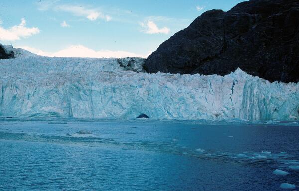
This ship-deck-based photograph of Muir Glacier and Muir Inlet, Glacier Bay National Park and Preserve, St. Elias Mountains, Alaska, is taken towards the north-northwest and shows the nearly 50-m-high retreating tidewater terminus of the glacier with part of its face capped by a few angular séracs.
This ship-deck-based photograph of Muir Glacier and Muir Inlet, Glacier Bay National Park and Preserve, St. Elias Mountains, Alaska, is taken towards the north-northwest and shows the nearly 50-m-high retreating tidewater terminus of the glacier with part of its face capped by a few angular séracs.