Repeat oblique photographs of Wolverine glacier in Alaska.
Repeat oblique photographs of Wolverine glacier in Alaska.Repeat oblique photographs of Wolverine glacier in Alaska. 1966 image by unknown USGS photographer; 2015 image by L. Sass, USGS.

Official websites use .gov
A .gov website belongs to an official government organization in the United States.
Secure .gov websites use HTTPS
A lock () or https:// means you’ve safely connected to the .gov website. Share sensitive information only on official, secure websites.
Images

Repeat oblique photographs of Wolverine glacier in Alaska. 1966 image by unknown USGS photographer; 2015 image by L. Sass, USGS.
Repeat oblique photographs of Wolverine glacier in Alaska. 1966 image by unknown USGS photographer; 2015 image by L. Sass, USGS.

Topographer Jim Tennant making measurements with a Wild T-2 theodolite on Mount Trumball in Arizona.
Topographer Jim Tennant making measurements with a Wild T-2 theodolite on Mount Trumball in Arizona.

Calvin Hazlewood works with a 48-inch Robertson copy camera.
Calvin Hazlewood works with a 48-inch Robertson copy camera.

Working with a small copy camera.
Working with a small copy camera.

Jay Prendergast adjusts the lens on a Robertson 48-inch, 4.5 ton camera. Installed in 1959, the camera was used for precise scale transformation of mapping separates and composites.
Jay Prendergast adjusts the lens on a Robertson 48-inch, 4.5 ton camera. Installed in 1959, the camera was used for precise scale transformation of mapping separates and composites.
Riparian vegetation has increased to the extent of blocking the downstream view. The channel appears to have shifted to the right, and the terrace is now occupied by cottonwood, black willow, and tamarisk. (Raymond M. Turner).
Riparian vegetation has increased to the extent of blocking the downstream view. The channel appears to have shifted to the right, and the terrace is now occupied by cottonwood, black willow, and tamarisk. (Raymond M. Turner).

U.S. Geological Survey streamflow-gaging station 08098290 Brazos River near Highbank, Texas, looking downstream from FM 413 bridge, March 31, 1964.
SIR 2009–5174
U.S. Geological Survey streamflow-gaging station 08098290 Brazos River near Highbank, Texas, looking downstream from FM 413 bridge, March 31, 1964.
SIR 2009–5174

U.S. Geological Survey streamflow-gaging station 08098290 Brazos River near Highbank, Texas, looking upstream from FM 413 bridge, March 31, 1964.
SIR 2009–5174
U.S. Geological Survey streamflow-gaging station 08098290 Brazos River near Highbank, Texas, looking upstream from FM 413 bridge, March 31, 1964.
SIR 2009–5174

Although large streamgage structures are no longer necessary, the USGS still uses some of them to contain modern streamgage equipment.
Although large streamgage structures are no longer necessary, the USGS still uses some of them to contain modern streamgage equipment.

USGS topographer Yukio Yamamoto in Littlefield, Texas with a theodolite and an Electrotape distance measuring unit.
USGS topographer Yukio Yamamoto in Littlefield, Texas with a theodolite and an Electrotape distance measuring unit.
The 1961 fissure eruption near Nāpau Crater was a short-lived but notable event on Kīlauea’s East Rift Zone, occurring in late September. Over two days, lava erupted from vents along a 13-mile stretch, producing 13 small flows and lava fountains that reached heights of up to 400 feet, with the largest flows occurring near Pāhoa.
The 1961 fissure eruption near Nāpau Crater was a short-lived but notable event on Kīlauea’s East Rift Zone, occurring in late September. Over two days, lava erupted from vents along a 13-mile stretch, producing 13 small flows and lava fountains that reached heights of up to 400 feet, with the largest flows occurring near Pāhoa.
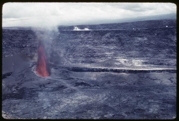
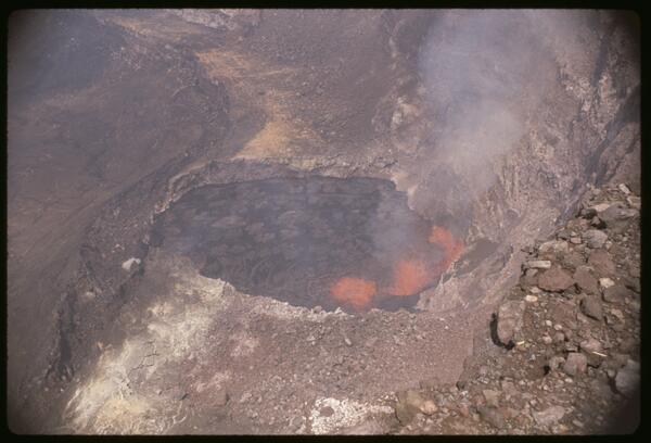
The July 1961 eruption at Halemaʻumaʻu was the third summit eruption of that year, continuing the pattern of vigorous volcanic activity at Kīlauea. This event featured sustained lava fountaining and further infilling of the crater, building upon the changes initiated by the February and March eruptions.
The July 1961 eruption at Halemaʻumaʻu was the third summit eruption of that year, continuing the pattern of vigorous volcanic activity at Kīlauea. This event featured sustained lava fountaining and further infilling of the crater, building upon the changes initiated by the February and March eruptions.
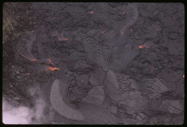
The March 1961 eruption at Halemaʻumaʻu was the second of three summit eruptions at Kīlauea that year, marked by renewed lava activity within the northeast collapse pit formed in February. This phase featured vigorous lava fountaining, crater floor uplift, and the gradual infilling of the pit, reflecting continued magma supply and dynamic summit processes.
The March 1961 eruption at Halemaʻumaʻu was the second of three summit eruptions at Kīlauea that year, marked by renewed lava activity within the northeast collapse pit formed in February. This phase featured vigorous lava fountaining, crater floor uplift, and the gradual infilling of the pit, reflecting continued magma supply and dynamic summit processes.
The February 1961 summit eruption of Kīlauea marked the beginning of a year of intense volcanic activity, characterized by three distinct summit eruptive phases.
The February 1961 summit eruption of Kīlauea marked the beginning of a year of intense volcanic activity, characterized by three distinct summit eruptive phases.

Sand erupted from a fissure overlies the original surface of gravel and cobbles. Looking west, Crillon Lake in middleground, September 1, 1958
Sand erupted from a fissure overlies the original surface of gravel and cobbles. Looking west, Crillon Lake in middleground, September 1, 1958

Low-level oblique aerial view of Fairweather fault. Photo taken east of North Dome, looking northwest, August 26, 1958.
Low-level oblique aerial view of Fairweather fault. Photo taken east of North Dome, looking northwest, August 26, 1958.

Artesian well investigations in South Dakota (circa-July 1957).
Artesian well investigations in South Dakota (circa-July 1957).

Stereoscopic control point check.
Stereoscopic control point check.

Bill Campbell operates an Electrical Survey Net Adjuster (ESNA). The ESNA was used for the adjustment of levels and traverse.
Bill Campbell operates an Electrical Survey Net Adjuster (ESNA). The ESNA was used for the adjustment of levels and traverse.

Map editor Webb Greenup reviews an overlay of the Atwater, CA 7.5-minute topographic quadrangle map.
Map editor Webb Greenup reviews an overlay of the Atwater, CA 7.5-minute topographic quadrangle map.

A USGS map editor plots General Land Office (GLO) data on a Shaw Mountain, Oregon manuscript.
A USGS map editor plots General Land Office (GLO) data on a Shaw Mountain, Oregon manuscript.