
A timelapse on the Great Salt Lake Hydro Mapper site shows changes in the surface area of the lake from 1985-2021. These stills show a comparison of the lake between 1986 and 2021.
Images
Images
Filter Total Items: 9452
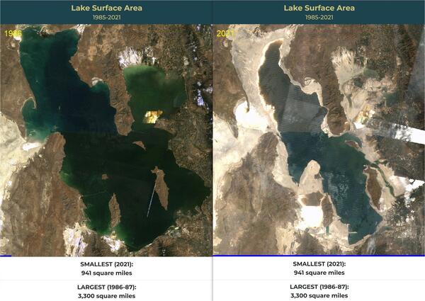
Great Salt Lake in 1986 and 2021
A timelapse on the Great Salt Lake Hydro Mapper site shows changes in the surface area of the lake from 1985-2021. These stills show a comparison of the lake between 1986 and 2021.

San Andreas Fault in SE Coachella Valley
Oblique aerial view of San Andreas Fault (between white arrows) in southeastern Coachella Valley, near Red Canyon; view to the west.
Oblique aerial view of San Andreas Fault (between white arrows) in southeastern Coachella Valley, near Red Canyon; view to the west.

USGS station 08110500 Navasota Riv. near Easterly, Tex.
USGS station 08110500 Navasota Riv. near Easterly, Tex.U.S. Geological Survey streamflow-gaging station 08110500 Navasota River near Easterly, Texas, looking upstream from left bank, July 22, 1985.
SIR 2009–5174
USGS station 08110500 Navasota Riv. near Easterly, Tex.
USGS station 08110500 Navasota Riv. near Easterly, Tex.U.S. Geological Survey streamflow-gaging station 08110500 Navasota River near Easterly, Texas, looking upstream from left bank, July 22, 1985.
SIR 2009–5174

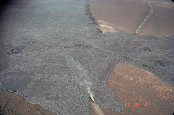
Aerial view of waning lava fountain, Kilauea Volcano, 1985
Aerial view of waning lava fountain, Kilauea Volcano, 1985Aerial view, from the east, of waning lava fountain from Pu'u 'O'o on Hawai'i Island's Kilauea Volcano. Taken at the end of eruption episode 32. Pu'u 'O'o rose 209 meters above the pre-1983 surface (928 meters above sea level).

Control Structure
The control structure between Lake Alice and Lake Irvine in 1985.
The control structure between Lake Alice and Lake Irvine in 1985.

Aerial View of Mauna Loa Volcano, Hawaii
USGS Hawaiian Volcano Observatory scientists monitor Mauna Loa, the largest active volcano on Earth. In this 1985 aerial photo, Mauna Loa looms above Kīlauea Volcano’s summit caldera (left center) and nearly obscures Hualālai in the far distance (upper right).
USGS Hawaiian Volcano Observatory scientists monitor Mauna Loa, the largest active volcano on Earth. In this 1985 aerial photo, Mauna Loa looms above Kīlauea Volcano’s summit caldera (left center) and nearly obscures Hualālai in the far distance (upper right).

Anammox Research Site on Cape Cod
An aerial view looking southeast of the treated-wastewater infiltration beds at Joint Base Cape Cod. The wastewater disposal beds (source of the nitrogen contamination) appear in the foreground. In the background is a freshwater pond that is receiving discharge of some of the groundwater contaminants. Toxic waste disposal at the site ended in 1995.
An aerial view looking southeast of the treated-wastewater infiltration beds at Joint Base Cape Cod. The wastewater disposal beds (source of the nitrogen contamination) appear in the foreground. In the background is a freshwater pond that is receiving discharge of some of the groundwater contaminants. Toxic waste disposal at the site ended in 1995.

Lava flows on Mauna Loa
Erupting vents on Mauna Loa’s northeast rift zone near Pu‘u‘ula‘ula (Red Hill) on Mar. 25, 1984, sent massive ‘a‘ā lava flows down the rift toward Kūlani.
Erupting vents on Mauna Loa’s northeast rift zone near Pu‘u‘ula‘ula (Red Hill) on Mar. 25, 1984, sent massive ‘a‘ā lava flows down the rift toward Kūlani.

USGS Topographers at Work
USGS topographers making an electronic distance measurement in a dry lake bed in Saline Valley in Death Valley, California.
USGS topographers making an electronic distance measurement in a dry lake bed in Saline Valley in Death Valley, California.

USGS Topographers at Work
USGS topographer running a traverse in the Alabama Hills near Mt. Whitney, California.
USGS topographer running a traverse in the Alabama Hills near Mt. Whitney, California.

USGS Topographers at Work
USGS topographer identifying a mine on a photograph in Death Valley.
USGS topographer identifying a mine on a photograph in Death Valley.

USGS Topographers at Work
USGS topographer with plane table and alidade in the Alabama Hills near Mt. Whitney, California.
USGS topographer with plane table and alidade in the Alabama Hills near Mt. Whitney, California.

USGS Topographers at Work
USGS topographer using a Topcon Guppy in the dunes of Saline Valley in Death Valley, California
USGS topographer using a Topcon Guppy in the dunes of Saline Valley in Death Valley, California

USGS Topographers at Work
USGS topographers doing a helicopter photo reconnaissance in Saline Valley in Death Valley, California.
USGS topographers doing a helicopter photo reconnaissance in Saline Valley in Death Valley, California.

Low fountain of lava from Pu'u 'O'o, Kilauea Volcano, 1983
Low fountain of lava from Pu'u 'O'o, Kilauea Volcano, 1983Low fountain, approximately 50 meters high, from Pu'u 'O'o on Hawai'i Island's Kilauea Volcano (viewed from the north). Lava issuing from the breach in the northeast rim of the crater produced an 'a'a flow that extended more than 4 kilometers. Eruption episode 8.

100-meter lava fountain, Kilauea Volcano, 1983
Pu'u 'O'o fountain approximately 100 meters high during eruption episode 8 on Hawai'i Island's Kilauea Volcano. Dark clots of spatter land near the base of the fountain, contributing to the growth of the cone. Less dense cinder, visible in the upper right, is carried downwind of the cone.
Pu'u 'O'o fountain approximately 100 meters high during eruption episode 8 on Hawai'i Island's Kilauea Volcano. Dark clots of spatter land near the base of the fountain, contributing to the growth of the cone. Less dense cinder, visible in the upper right, is carried downwind of the cone.

Lava ball, Kilauea Volcano, 1983
Accretionary lava ball comes to rest on the grass after rolling off the top of an 'a'a flow in Royal Gardens subdivision on Hawai'i Island's Kilauea Volcano. Accretionary lava balls form as viscous lava is molded around a core of already-soldified lava.
Accretionary lava ball comes to rest on the grass after rolling off the top of an 'a'a flow in Royal Gardens subdivision on Hawai'i Island's Kilauea Volcano. Accretionary lava balls form as viscous lava is molded around a core of already-soldified lava.

Pu'u 'O'o cinder-and-spatter cone, Kilauea Volcano, 1983
Pu'u 'O'o cinder-and-spatter cone, Kilauea Volcano, 1983View at dusk of the young Pu'u 'O'o cinder-and-spatter cone, with fountain 40 meters high, on Hawai'i Island's Kilauea Volcano (episode 5).
Pu'u 'O'o cinder-and-spatter cone, Kilauea Volcano, 1983
Pu'u 'O'o cinder-and-spatter cone, Kilauea Volcano, 1983View at dusk of the young Pu'u 'O'o cinder-and-spatter cone, with fountain 40 meters high, on Hawai'i Island's Kilauea Volcano (episode 5).

Arching fountain of lava, Kilauea Volcano, 1983
Arching fountain of lava approximately 10 meters high issuing from the western end of the 0740 vents, a series of spatter cones 170 meters long, south of Pu'u Kahaualea on Hawai'i Island's Kilauea Volcano (episode 2). Episodes 2 and 3 were characterized by spatter and cinder cones, such as Pu'u Halulu, which was 60 meters high by episode 3.
Arching fountain of lava approximately 10 meters high issuing from the western end of the 0740 vents, a series of spatter cones 170 meters long, south of Pu'u Kahaualea on Hawai'i Island's Kilauea Volcano (episode 2). Episodes 2 and 3 were characterized by spatter and cinder cones, such as Pu'u Halulu, which was 60 meters high by episode 3.

Forest of lava trees, Kilauea Volcano, 1983
Forest of lava trees resulting from eruption of a 1-km-line of vents east of Pu'u Kahaulea on Hawai'i Island's Kilauea Volcano. The bulbous top of each lava tree marks the high stand of the lava flow as it spread through the trees.
Forest of lava trees resulting from eruption of a 1-km-line of vents east of Pu'u Kahaulea on Hawai'i Island's Kilauea Volcano. The bulbous top of each lava tree marks the high stand of the lava flow as it spread through the trees.
September 1982 Kaluapele Eruption
The September 25, 1982, Kaluapele eruption was a brief but vigorous event that followed nearly two hours of seismic unrest and rapid summit inflation. Lava erupted from a 1,150-foot-long fissure near the southern end of the caldera, producing fountains up to 220 feet high.
The September 25, 1982, Kaluapele eruption was a brief but vigorous event that followed nearly two hours of seismic unrest and rapid summit inflation. Lava erupted from a 1,150-foot-long fissure near the southern end of the caldera, producing fountains up to 220 feet high.