
Following the devastating 2010 Haiti earthquake, the USGS has been helping with earthquake awareness and monitoring in the country, with continued support from the U.S. Agency for International Development (USAID).
Images
Images
Filter Total Items: 9454

Earthquake Education and Outreach in Haiti
Following the devastating 2010 Haiti earthquake, the USGS has been helping with earthquake awareness and monitoring in the country, with continued support from the U.S. Agency for International Development (USAID).

Loon Carcasses
NPS citizen scientist Eleanor Comings counts loon carcasses at Sleeping Bear Dunes National Lakeshore during a large botulism outbreak in October of 2012.
NPS citizen scientist Eleanor Comings counts loon carcasses at Sleeping Bear Dunes National Lakeshore during a large botulism outbreak in October of 2012.

USGS Ecologist Carlton Rochester Handling a Rattlesnake
USGS Ecologist Carlton Rochester Handling a RattlesnakeA screenshot from the USGS film "Living with Fire".
USGS Western Ecological Research Center ecologist Carlton Rochester handles a rattlesnake in San Diego County, Calif.
USGS Ecologist Carlton Rochester Handling a Rattlesnake
USGS Ecologist Carlton Rochester Handling a RattlesnakeA screenshot from the USGS film "Living with Fire".
USGS Western Ecological Research Center ecologist Carlton Rochester handles a rattlesnake in San Diego County, Calif.
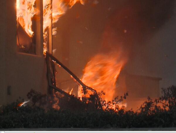
A Fire Tornado Swirls Near a Home in Southern California
A Fire Tornado Swirls Near a Home in Southern CaliforniaA screenshot from the USGS film "Living with Fire".
A fire tornado swirls near a home in southern California. USGS is investigating the factors that dictate home loss from wildfires as part of the USGS Southern California Wildfire Risk Scenario Project.
Image courtesy of Tim Walton, Photo One Productions, CALFIRE. Shared with permission.

Black-necked Stilt Chick
Birds found in and around the Salton Sea, California.
Birds found in and around the Salton Sea, California.

Middle Dam (Maine) Well Drilling
USGS hydrologist Martha Nielsen examines cuttings as a drill crew works to drill a new monitoring well at USGS station 443647070552303 (ME-OW400A) near Middle Dam on Lower Richardson Lake. The existing well heaved due to frost and had to be replaced.
USGS hydrologist Martha Nielsen examines cuttings as a drill crew works to drill a new monitoring well at USGS station 443647070552303 (ME-OW400A) near Middle Dam on Lower Richardson Lake. The existing well heaved due to frost and had to be replaced.

Family of Florida Panthers
A family of Florida panthers walking in the night.
A family of Florida panthers walking in the night.

Mw6.6 Lushan China Earthquake, April 20 2013
Damage to a village house. Longxingcun.

Miradiscops opal
Miradiscops opal shell viewed with a scanning electron microscope.
Miradiscops opal shell viewed with a scanning electron microscope.

Thysanophora caecoides
Thysanophora caecoides shell viewed with a scanning electron microscope.
Thysanophora caecoides shell viewed with a scanning electron microscope.

Spiraxis sp.
Spiraxis sp. shell viewed with a scanning electron microscope with aperture facing up.
Spiraxis sp. shell viewed with a scanning electron microscope with aperture facing up.

Geologic Studies on Sitkinak Island, Alaska
Geologists examine cores on Sitkinak Island, Alaska.
Geologists examine cores on Sitkinak Island, Alaska.

Geologic Studies on Sitkinak Island, Alaska
Base camp, Sitkinak Island.

Geologic Studies on Sitkinak Island, Alaska
Geologists examine an exposure of a tidal marsh bank on Sitkinak Island, Alaska. The bank exposes interbedded peat and silt that records sudden vertical land movements associated with megathrust fault slip during large earthquakes.
Geologists examine an exposure of a tidal marsh bank on Sitkinak Island, Alaska. The bank exposes interbedded peat and silt that records sudden vertical land movements associated with megathrust fault slip during large earthquakes.

Geologic Studies on Sitkinak Island, Alaska
A tidal marsh bank exposed during low tide on Sitkinak Island, Alaska. The bank reveals ledges of alternating peat and silt. Abrupt uplift and subsidence during large megathrust earthquakes is interpreted to be the cause of the alternating layers.
A tidal marsh bank exposed during low tide on Sitkinak Island, Alaska. The bank reveals ledges of alternating peat and silt. Abrupt uplift and subsidence during large megathrust earthquakes is interpreted to be the cause of the alternating layers.

Boxelder Bugs Gather on the Leaves of Hosta
Adult, immature, and nymph stage box elder bugs gather on the leaves of a hosta plant growing at the base of a silver maple tree. Adults have fully formed, mainly black wings.
Adult, immature, and nymph stage box elder bugs gather on the leaves of a hosta plant growing at the base of a silver maple tree. Adults have fully formed, mainly black wings.

Horseshoe Crab (Limulus polyphemus)
A complete shell of a horseshoe crab lies in the tidal line on a beach among dried seaweeds.
A complete shell of a horseshoe crab lies in the tidal line on a beach among dried seaweeds.

Studying Marsh Subsidence
National Wetlands Research Center workers set bench marks to study marsh subsidence.
National Wetlands Research Center workers set bench marks to study marsh subsidence.

Mexican Mojarra Fish (Cichlasoma urophthalmus)
Mexican mojarra fish swim around a submerged log in a freshwater upwelling or cenote that runs into a coastal estuary.
Mexican mojarra fish swim around a submerged log in a freshwater upwelling or cenote that runs into a coastal estuary.

Shortnose Sturgeon (Acipenser brevirostrum)
Scanning shortnose sturgeon for PIT (Passive Integrated Transponder) identification tag, used to permanently mark fish.
Scanning shortnose sturgeon for PIT (Passive Integrated Transponder) identification tag, used to permanently mark fish.