
USGS geophysicist Anjana Shah stands next to a Cessna Grand Caravan airplane that took measurements over Virginia's Louisa, Goochland and Fluvanna counties. The data collected will help USGS scientists locate buried geologic features associated with the August 23, 2011 earthquake and its aftershocks. Surveys were conducted from 7/15- 7/25.
Images
Images
Filter Total Items: 9454

USGS Maps Virginia's Underground Faults
USGS geophysicist Anjana Shah stands next to a Cessna Grand Caravan airplane that took measurements over Virginia's Louisa, Goochland and Fluvanna counties. The data collected will help USGS scientists locate buried geologic features associated with the August 23, 2011 earthquake and its aftershocks. Surveys were conducted from 7/15- 7/25.

Deforested Slope, Cayaguas Watershed
An example of a deforested slope in the Cayaguas watershed, eastern Puerto Rico. Such areas are more susceptible to landslides.
An example of a deforested slope in the Cayaguas watershed, eastern Puerto Rico. Such areas are more susceptible to landslides.

House Damage from 2011 Central Virginia Earthquake
House Damage from 2011 Central Virginia EarthquakeDamage to a house in Louisa County, Virginia, after a magnitude 5.8 earthquake on August 23, 2011.
House Damage from 2011 Central Virginia Earthquake
House Damage from 2011 Central Virginia EarthquakeDamage to a house in Louisa County, Virginia, after a magnitude 5.8 earthquake on August 23, 2011.

Aerial Oblique Photography Comparing Dauphin Island Before and After Hurricane Isaac
Aerial Oblique Photography Comparing Dauphin Island Before and After Hurricane IsaacPhotos from Dauphin Island indicate beach erosion and island overwash, furthering the erosion the island has seen during repeated storm events -- Ivan, Katrina, Gustav and Isaac -- that have led to the island's increased vulnerability to future storms.

USGS Researcher at Mesa Alta, New Mexico
USGS researcher Craig Allen stands on the edge of Mesa Alta, amid diverse forest and woodland in the uplands of northern New Mexico; note some recently dead ponderosa pine and Douglas-fir in the field of view. Forest drought stress is strongly correlated with tree mortality from poor growth, bark beetle outbreaks, and high-severity fire.
USGS researcher Craig Allen stands on the edge of Mesa Alta, amid diverse forest and woodland in the uplands of northern New Mexico; note some recently dead ponderosa pine and Douglas-fir in the field of view. Forest drought stress is strongly correlated with tree mortality from poor growth, bark beetle outbreaks, and high-severity fire.

Ice Core
Mikhail Kanevsiy (University of Alaska, Fairbanks) holding a core of ice-rich permafrost from about 2m depth.
Mikhail Kanevsiy (University of Alaska, Fairbanks) holding a core of ice-rich permafrost from about 2m depth.
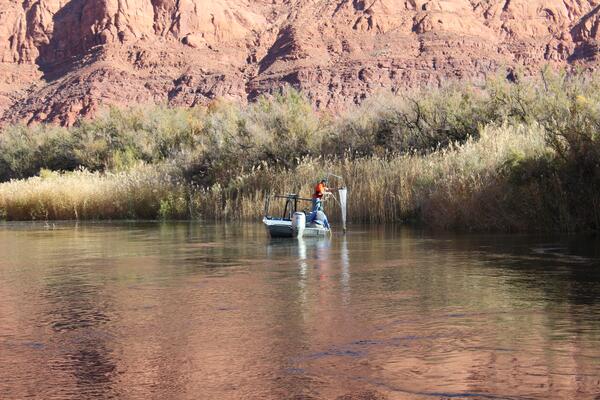
Sampling in the Grand Canyon High Flow Experiment
USGS Aquatic Ecologist Ted Kennedy sampling invertebrate and organic drift at Lees Ferry during the November 19, 2012 HFE.
USGS Aquatic Ecologist Ted Kennedy sampling invertebrate and organic drift at Lees Ferry during the November 19, 2012 HFE.
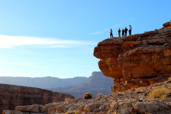
Beaver Creek Rapid
USGS staff Kyrie Fry and Scott Vanderkooi as well as BOR Employees Katrina Grantz, Mary Barger, and Glen Knowles look down at Beaver Creek Rapid.
USGS staff Kyrie Fry and Scott Vanderkooi as well as BOR Employees Katrina Grantz, Mary Barger, and Glen Knowles look down at Beaver Creek Rapid.
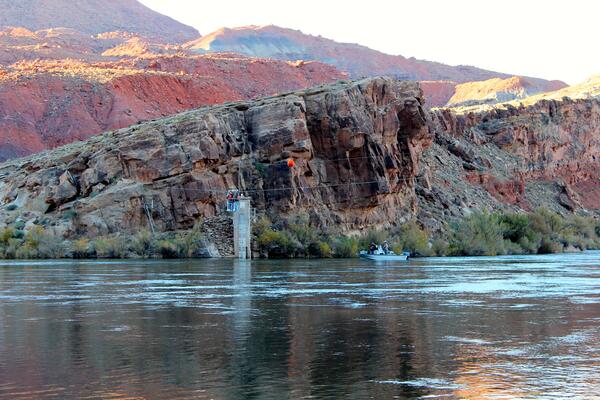
Suspended Scientists
USGS scientists up on the cable way at Lees Ferry measuring suspended-sediment transport.
USGS scientists up on the cable way at Lees Ferry measuring suspended-sediment transport.
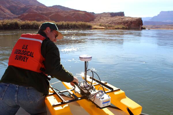
Measuring Suspended-Sediment Transport
USGS's Arizona Water Science Center's Dave Anning on cable way at Lees Ferry measuring suspended-sediment transport.
USGS's Arizona Water Science Center's Dave Anning on cable way at Lees Ferry measuring suspended-sediment transport.

Russian Crown Jewels from the USGS Library
Previously undiscovered photo of undocumented Russian Crown Jewels were recently discovered in the USGS library. The photo appear in a 1922 album called "Russian Diamond Fund," that was uncovered in the rare book room of the library. This necklace was one of the four undocumented jewels.
Previously undiscovered photo of undocumented Russian Crown Jewels were recently discovered in the USGS library. The photo appear in a 1922 album called "Russian Diamond Fund," that was uncovered in the rare book room of the library. This necklace was one of the four undocumented jewels.

Aquia Creek Sandstone
This Aquia Creek Sandstone originated from a quarry about 40 miles south of Washington, D.C., in Stafford County, Va. This type of stone was used in the construction of many of D.C.'s most famous landmarks, including the White House and the U.S. Capitol building.
This Aquia Creek Sandstone originated from a quarry about 40 miles south of Washington, D.C., in Stafford County, Va. This type of stone was used in the construction of many of D.C.'s most famous landmarks, including the White House and the U.S. Capitol building.

Gas Hydrates Research Project in Japan
Scientists from AIST, JOGMEC, Georgia Tech, and the USGS prepare to analyze pressure cores as part of a multi-year gas hydrates research project in Japan. The cores and pressure vessels are very heavy to move around, so they are using an overhead hoist system with chains to move the devices.
Scientists from AIST, JOGMEC, Georgia Tech, and the USGS prepare to analyze pressure cores as part of a multi-year gas hydrates research project in Japan. The cores and pressure vessels are very heavy to move around, so they are using an overhead hoist system with chains to move the devices.

Gas Hydrates Research Project in Japan
Scientists from AIST, JOGMEC, Georgia Tech, and the USGS prepare to analyze pressure cores as part of a multi-year gas hydrates research project in Japan. In this photo is Marco Terzariol (Georgia Tech) is preparing a Direct Shear Cell for testing a core section from the manipulator (background), storage chamber, and ball valve system (left).
Scientists from AIST, JOGMEC, Georgia Tech, and the USGS prepare to analyze pressure cores as part of a multi-year gas hydrates research project in Japan. In this photo is Marco Terzariol (Georgia Tech) is preparing a Direct Shear Cell for testing a core section from the manipulator (background), storage chamber, and ball valve system (left).

2013 Gas Hydrate Expedition in Gulf of Mexico
The USGS's Tom O'Brien, Patrick Hart (who is a co-chief scientist for the cruise) and Jenny White adjust seismic streamers and prepare to collect data on gas hydrates in the deepwater Gulf of Mexico aboard the research vessel Pelican in April to May, 2013.
The USGS's Tom O'Brien, Patrick Hart (who is a co-chief scientist for the cruise) and Jenny White adjust seismic streamers and prepare to collect data on gas hydrates in the deepwater Gulf of Mexico aboard the research vessel Pelican in April to May, 2013.

2013 Gas Hydrate Expedition in Gulf of Mexico
USGS technician Pete Dal Ferro prepares a generator-injector seismic source aboard the research ship Pelican during a cruise to study gas hydrates in the deepwater Gulf of Mexico in April and May 2013.
USGS technician Pete Dal Ferro prepares a generator-injector seismic source aboard the research ship Pelican during a cruise to study gas hydrates in the deepwater Gulf of Mexico in April and May 2013.

2013 Gas Hydrate Expedition in Gulf of Mexico
USGS technician Jenny White and Ray Sliter check instruments on the fantail of the research vessel Pelican during a cruise to explore gas hydrates in the deepwater Gulf of Mexico from April to May, 2013.
USGS technician Jenny White and Ray Sliter check instruments on the fantail of the research vessel Pelican during a cruise to explore gas hydrates in the deepwater Gulf of Mexico from April to May, 2013.

2013 Gas Hydrate Expedition in Gulf of Mexico
USGS technicians Tom O'Brien, Eric Moore, and Wayne Baldwin deploy the seismic streamer aboard the research vessel Pelican to collect data on gas hydrates in the deepwater Gulf of Mexico from April to May, 2013.
USGS technicians Tom O'Brien, Eric Moore, and Wayne Baldwin deploy the seismic streamer aboard the research vessel Pelican to collect data on gas hydrates in the deepwater Gulf of Mexico from April to May, 2013.

2013 Gas Hydrate Expedition in Gulf of Mexico
USGS technicians Eric Moore, Wayne Baldwin, and Tom O'Brien ready the 72-channel digital streamer for deployment on the research vessel Pelican during a cruise to explore gas hydrates in the deepwater Gulf of Mexico from April to May, 2013.
USGS technicians Eric Moore, Wayne Baldwin, and Tom O'Brien ready the 72-channel digital streamer for deployment on the research vessel Pelican during a cruise to explore gas hydrates in the deepwater Gulf of Mexico from April to May, 2013.

2013 Gas Hydrate Expedition in Gulf of Mexico
Seismic equipment is craned off the research vessel Pelican at the dock in Cocodrie, Louisiana after a 15-day expedition to explore gas hydrates in the deepwater Gulf of Mexico.
Seismic equipment is craned off the research vessel Pelican at the dock in Cocodrie, Louisiana after a 15-day expedition to explore gas hydrates in the deepwater Gulf of Mexico.

Great Lakes Beach Health
As schools close for the year and summer weather beckons, many recreationalists head to the Great Lakes' public beaches. However, these coastal areas can become contaminated with disease-causing bacteria that threaten public health, disrupt water recreation, and pay a toll on the Great Lakes economies that depend on summer tourism.
As schools close for the year and summer weather beckons, many recreationalists head to the Great Lakes' public beaches. However, these coastal areas can become contaminated with disease-causing bacteria that threaten public health, disrupt water recreation, and pay a toll on the Great Lakes economies that depend on summer tourism.