
USGS crews had two research vessels out measuring streamflow on the Mississippi River at St. Louis on New Years Eve, 2015. USGS scientists Eric Looper and Jason Carron are one of many USGS field crews out in the floodwaters over the holiday.
Images
Images
Filter Total Items: 9454

Flooding on Mississippi River in December 2015
USGS crews had two research vessels out measuring streamflow on the Mississippi River at St. Louis on New Years Eve, 2015. USGS scientists Eric Looper and Jason Carron are one of many USGS field crews out in the floodwaters over the holiday.

Flooding on Mississippi River in December 2015
USGS scientists Chris Rowden, Larry Buschmann and Bob Holmes were on the Mississippi River at St. Louis taking streamflow measurements on New Years Eve, 2015. This information is critical to the National Weather Service, the U.S. Army Corps of Engineers and emergency managers in making flood predictions and response.
USGS scientists Chris Rowden, Larry Buschmann and Bob Holmes were on the Mississippi River at St. Louis taking streamflow measurements on New Years Eve, 2015. This information is critical to the National Weather Service, the U.S. Army Corps of Engineers and emergency managers in making flood predictions and response.

Headscarp of Red Bluffs Landslide Overlooking Crescent Lake Landslide
Headscarp of Red Bluffs Landslide Overlooking Crescent Lake LandslideView out over the Crescent Lake landslide from the headscarp (left foreground) of the Red Bluffs landslide, looking toward Stevenson, Washington and the Columbia River.

SCUBA Diver Collects Corals for Paleoclimate
A USGS SCUBA Diver Collects a Core from a Coral Using a Hydraulic Drilling System in the U.S. Virgin Islands. USGS Image (I. Kuffner).
A USGS SCUBA Diver Collects a Core from a Coral Using a Hydraulic Drilling System in the U.S. Virgin Islands. USGS Image (I. Kuffner).

Collecting permafrost information on the Tahana River
Collecting permafrost information on the Tahana RiverDavid Pelunis-Messier and Milton Roberts navigating on the Tanana River, a main tributary of the Yukon River. The two are taking part in the Yukon River permafrost study.
Collecting permafrost information on the Tahana River
Collecting permafrost information on the Tahana RiverDavid Pelunis-Messier and Milton Roberts navigating on the Tanana River, a main tributary of the Yukon River. The two are taking part in the Yukon River permafrost study.

Elkhorn coral anchors a healthy reef
Healthy Elkhorn coral (Acropora palmata) near unpopulated Buck Island, U.S. Virgin Islands. Elkhorn coral is one of many important reef-building species that create 3D structure on the seafloor. Coral reef structure provides habitat for marine life and helps break up waves as they approach the coastline.
Healthy Elkhorn coral (Acropora palmata) near unpopulated Buck Island, U.S. Virgin Islands. Elkhorn coral is one of many important reef-building species that create 3D structure on the seafloor. Coral reef structure provides habitat for marine life and helps break up waves as they approach the coastline.

USGS streamgage on the Trask River
Trask River stage, discharge, and water-quality data are collected and used together to help monitor the current health of the river. Instream equipment is stored in protective housing to protect it from the elements. Data from the river are sent to equipment in the gage house, where it is stored then transmitted to USGS servers.
Trask River stage, discharge, and water-quality data are collected and used together to help monitor the current health of the river. Instream equipment is stored in protective housing to protect it from the elements. Data from the river are sent to equipment in the gage house, where it is stored then transmitted to USGS servers.

USGS Scientists Seeking Finchite by the Sulfur Springs Draw in Texas
USGS Scientists Seeking Finchite by the Sulfur Springs Draw in TexasBetween Lamesa and Big Spring, Texas, runs the Sulfur Spring Draw, a dry creek. It's the site of an economic calcrete-type uranium deposit, the Sulfur Springs Draw Deposit, where a new mineral was discovered in 2015.

Wading in the breach to precisely measure it
USGS employee Owen Brenner walks across the Fire Island wilderness breach carrying a GPS backpack that allows him to collect precise elevation data in the shallows.
USGS employee Owen Brenner walks across the Fire Island wilderness breach carrying a GPS backpack that allows him to collect precise elevation data in the shallows.

Scientist Gathering Data
Karen Nelson (USFWS) acquiring geophysical data amidst a naturally occurring plant (Salicornia rubra) in northeastern Montana.
Karen Nelson (USFWS) acquiring geophysical data amidst a naturally occurring plant (Salicornia rubra) in northeastern Montana.

Burmese python hatchling
Non-native Burmese pythons have established a breeding population in South Florida and are one of the most concerning invasive species in Everglades National Park. This photograph is of a Burmese python hatchling
Non-native Burmese pythons have established a breeding population in South Florida and are one of the most concerning invasive species in Everglades National Park. This photograph is of a Burmese python hatchling

Iiwi on Mamane
The Hawaiian ‘I‘iwi, a native forest bird species only found in the Hawaiian Islands.
The Hawaiian ‘I‘iwi, a native forest bird species only found in the Hawaiian Islands.
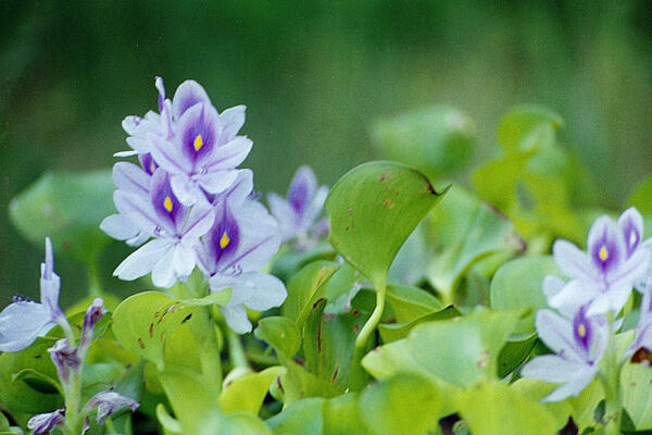
Common water-hyacinth
Water hyacinth is an invasive plant species that once introduced to a new region it quickly establishes and spreads, competing against native plants.
Water hyacinth is an invasive plant species that once introduced to a new region it quickly establishes and spreads, competing against native plants.

Laboratory set up with water sample
Experimental laboratory setup to study uranium in aquatic organisms. Bottles contain artificial freshwater amended with dissolved organic matter and a range of uranium concentrations.
Experimental laboratory setup to study uranium in aquatic organisms. Bottles contain artificial freshwater amended with dissolved organic matter and a range of uranium concentrations.

Flooding on Mississippi River in December 2015
USGS crews had two research vessels out measuring streamflow on the Mississippi River at St. Louis on New Years Eve, 2015.
USGS crews had two research vessels out measuring streamflow on the Mississippi River at St. Louis on New Years Eve, 2015.

Flooding on Mississippi River in December 2015
USGS scientist Chris Rowden drives a research vessel measuring streamflow alongside another field crew on the Mississippi River at St. Louis.
USGS scientist Chris Rowden drives a research vessel measuring streamflow alongside another field crew on the Mississippi River at St. Louis.

USGS Volunteer Student at the Smithsonian Natural History Museum
USGS Volunteer Student at the Smithsonian Natural History MuseumThe Smithsonian Natural History Museum offers hands-on learning experiences.
USGS Volunteer Student at the Smithsonian Natural History Museum
USGS Volunteer Student at the Smithsonian Natural History MuseumThe Smithsonian Natural History Museum offers hands-on learning experiences.

Researcher takes winter water chemistry samples on the Yukon River
Researcher takes winter water chemistry samples on the Yukon RiverResearcher Carol Hasburgh taking winter water chemistry samples on the Yukon River for a permafrost loss study.
Researcher takes winter water chemistry samples on the Yukon River
Researcher takes winter water chemistry samples on the Yukon RiverResearcher Carol Hasburgh taking winter water chemistry samples on the Yukon River for a permafrost loss study.

Monarchs
The Eastern, migratory population of monarch butterflies has declined by about 80 percent over the last decade.
The Eastern, migratory population of monarch butterflies has declined by about 80 percent over the last decade.

Corals die, turn to rubble
These Elkhorn corals (Acropora palmata) near Buck Island, U.S. Virgin Islands have died and collapsed into rubble. As coral reef structure degrades, valuable habitat for marine life is lost and nearby coastlines become more susceptible to storms, waves and erosion.
These Elkhorn corals (Acropora palmata) near Buck Island, U.S. Virgin Islands have died and collapsed into rubble. As coral reef structure degrades, valuable habitat for marine life is lost and nearby coastlines become more susceptible to storms, waves and erosion.

Scanning Electron Microscope Image of Finchite
A scanning electron microscope image of the newly discovered mineral finchite. The Denver Microbeam Lab provided this scan of finchite in order to help describe and identify the mineral as a new one. Finchite is a uranium mineral first observed in Martin County, Texas.
A scanning electron microscope image of the newly discovered mineral finchite. The Denver Microbeam Lab provided this scan of finchite in order to help describe and identify the mineral as a new one. Finchite is a uranium mineral first observed in Martin County, Texas.