
Tsunami evacuation route sign at an intersection in Nehalem, Oregon.
Images
Images
Filter Total Items: 9454

Tsunami Evacuation Sign
Tsunami evacuation route sign at an intersection in Nehalem, Oregon.
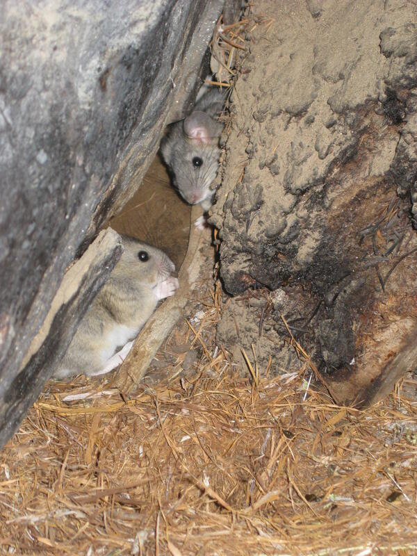
Packrats and Their Midden
Packrats near their midden in the City of Rocks National Reserve. USGS Image (J. Betancourt).
Packrats near their midden in the City of Rocks National Reserve. USGS Image (J. Betancourt).

Permafrost Loss Dramatically Changes Yukon River Chemistry and Hydrolo
Permafrost Loss Dramatically Changes Yukon River Chemistry and HydroloYukon River freezing up at Pilot Station, AK
Permafrost Loss Dramatically Changes Yukon River Chemistry and Hydrolo
Permafrost Loss Dramatically Changes Yukon River Chemistry and HydroloYukon River freezing up at Pilot Station, AK

Whitefish drying on a fish rack in Pilot Station, AK
Whitefish drying on a fish rack in Pilot Station, AKWhitefish drying on a fish rack in Pilot Station, AK, in the Yukon River Basin.
Whitefish drying on a fish rack in Pilot Station, AK
Whitefish drying on a fish rack in Pilot Station, AKWhitefish drying on a fish rack in Pilot Station, AK, in the Yukon River Basin.

USGS scientist collects samples in a New Jersey salt marsh
USGS scientist collects samples in a New Jersey salt marshCaption: USGS scientist Zafer Defne measures water and sediment movement at Forsythe National Wildlife Refuge, New Jersey. Defne is co-author with USGS' Neil Ganju of a 2017 study on how to estimate coastal salt marshes' potential longevity, based on their sediment budgets and the ratio of open water to vegetation. Photo: Sandra Brosnahan, USGS

Collecting a Gas Hydrate Research Core from the Indian Ocean
Collecting a Gas Hydrate Research Core from the Indian OceanScientists aboard the D/S Chikyu prepare to collect a research core drilled from marine sediments in the Indian Ocean. This research is part of the 2015 Indian National Gas Hydrate Program Expedition 02 (NGHP-02), which is a follow-up to the 2006 NGHP-01.

Finchite Mineral
A sample of finchite, a newly discovered uranium mineral. Finchite is the yellow material on the surface of the rock. Finchite is found in the late Pleistocene sediments deposited during the Illinoian glacial stage.
A sample of finchite, a newly discovered uranium mineral. Finchite is the yellow material on the surface of the rock. Finchite is found in the late Pleistocene sediments deposited during the Illinoian glacial stage.

USGS Scientist Examining Texas Rock Layers for Finchite Minerals
USGS Scientist Examining Texas Rock Layers for Finchite MineralsUSGS scientist Bradley Van Gosen examines rock layers for the newly discovered mineral finchite near Lamesa, Texas.
USGS Scientist Examining Texas Rock Layers for Finchite Minerals
USGS Scientist Examining Texas Rock Layers for Finchite MineralsUSGS scientist Bradley Van Gosen examines rock layers for the newly discovered mineral finchite near Lamesa, Texas.

Barred Owl
Barred owls like this one were most strongly associated with patches of large hardwood and conifer trees in relatively flat areas along streams.
Barred owls like this one were most strongly associated with patches of large hardwood and conifer trees in relatively flat areas along streams.

Flooded Road near USGS gaging station 01055500 in Turner, Maine
Flooded Road near USGS gaging station 01055500 in Turner, MaineStop sign at the end of School House Hill Rd in Turner, Maine near USGS gaging station 01055500 on the Nezinscot River.
Flooded Road near USGS gaging station 01055500 in Turner, Maine
Flooded Road near USGS gaging station 01055500 in Turner, MaineStop sign at the end of School House Hill Rd in Turner, Maine near USGS gaging station 01055500 on the Nezinscot River.

Pallid Sturgeon
An adult pallid sturgeon, an endangered species.
An adult pallid sturgeon, an endangered species.
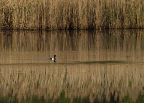
Lesser Scaup
A drake lesser scaup drops in at the Fort Smallwood Park in Maryland for a couple minutes before continuing north. This bird was not part of this new research. Photograph taken April 15, 2012. Credit: Bill Hubick.
A drake lesser scaup drops in at the Fort Smallwood Park in Maryland for a couple minutes before continuing north. This bird was not part of this new research. Photograph taken April 15, 2012. Credit: Bill Hubick.

Scientists Collect Arctic Sediments
Scientists aboard USCGC Healy prepare to collect sediments from the Chukchi that will be used to reconstruct sea-ice history in the Arctic. USGS Image (L. Gemery).
Scientists aboard USCGC Healy prepare to collect sediments from the Chukchi that will be used to reconstruct sea-ice history in the Arctic. USGS Image (L. Gemery).

Heading out to do field work for a permafrost study in the Yukon River
Heading out to do field work for a permafrost study in the Yukon RiverHeading out to do field work for a permafrost loss study in the Yukon River Basin.
Heading out to do field work for a permafrost study in the Yukon River
Heading out to do field work for a permafrost study in the Yukon RiverHeading out to do field work for a permafrost loss study in the Yukon River Basin.

Frac Sands in Hand
Frac sands used in unconventional oil and gas development.
Frac sands used in unconventional oil and gas development.

Setting up a science base in a barrier island wilderness
Setting up a science base in a barrier island wildernessUSGS scientist BJ Reynolds sets up a solar-powered, satellite-uplinked GPS base station in the Fire Island Wilderness Area to support detailed elevation surveys.
Setting up a science base in a barrier island wilderness
Setting up a science base in a barrier island wildernessUSGS scientist BJ Reynolds sets up a solar-powered, satellite-uplinked GPS base station in the Fire Island Wilderness Area to support detailed elevation surveys.

Calcrete near Sulfur Springs Draw
A calcrete outcropping near Sulfur Springs Draw in Texas. This deposit dates to the Pliocene and Pleistocene, and hosts uranium-vanadate minerals.
A calcrete outcropping near Sulfur Springs Draw in Texas. This deposit dates to the Pliocene and Pleistocene, and hosts uranium-vanadate minerals.

Uranium-Vanadate Mineral in Calcrete
A uranium-vanadate mineral in calcrete. This sample came from near the Sulfur Springs Draw in Texas. USGS conducted an assessment of uranium resources in this region in 2015.
A uranium-vanadate mineral in calcrete. This sample came from near the Sulfur Springs Draw in Texas. USGS conducted an assessment of uranium resources in this region in 2015.

Running stream
A picture of a flowing stream. Water is flowing over rocks creating a small waterfall. The vegetation along the stream bank is green and lush.
A picture of a flowing stream. Water is flowing over rocks creating a small waterfall. The vegetation along the stream bank is green and lush.

USGS Measures Historic Flooding Across the Nation
USGS scientists Paul Rydlund, Eric Looper and Jason Carron dock the boat and coordinate with emergency managers.
USGS scientists Paul Rydlund, Eric Looper and Jason Carron dock the boat and coordinate with emergency managers.

USGS Measures Historic Flooding Across the Nation
USGS scientists Chris Rowden, Larry Buschmann and Bob Holmes were on the Mississippi River at St. Louis taking streamflow measurements on New Years Eve. This information is critical to the National Weather Service, the U.S. Army Corps of Engineers and emergency managers in making flood predictions and response.
USGS scientists Chris Rowden, Larry Buschmann and Bob Holmes were on the Mississippi River at St. Louis taking streamflow measurements on New Years Eve. This information is critical to the National Weather Service, the U.S. Army Corps of Engineers and emergency managers in making flood predictions and response.