
Water
Where can I find flood maps?
What is the difference between a confined and unconfined aquifer?
Does the use of pesticides affect our Nation's water quality?
How much natural water is there?
The USGS monitors and studies a wide range of water resources and water conditions, including streamflow, groundwater, water quality, and water use and availability.
How do River DroughtCast models work, and how is uncertainty estimated? How do River DroughtCast models work, and how is uncertainty estimated?
We use machine learning models to forecast streamflow drought by training them on 20- and 40-year periods of past streamflow, weather, and watershed data. For a summary of our methods and how we evaluate the models, see: Publication summarizing modeling methods and performance. Interactive guide showing how drought models work. Model input data, including daily weather, snow, soil moisture, and...
How is streamflow drought identified, and how is it different from other drought types? How is streamflow drought identified, and how is it different from other drought types?
Hydrological drought happens when there is unusually low flow in rivers and streams, as well as low levels in lakes, reservoirs, and groundwater. It usually follows meteorological drought, which occurs first when a lack of rainfall over a long period leads to a water shortage. Meteorological drought can be tracked using the Standardized Precipitation Index (SPI) or the Standardized Precipitation...
How should River DroughtCast drought conditions and forecasts be interpreted at different locations? How should River DroughtCast drought conditions and forecasts be interpreted at different locations?
When watersheds have been modified due to human activities, it can be complex to characterize hydrological drought using streamflow percentiles. For example, in areas downstream of dams, streamflow that falls below normal percentiles may reflect drought in systems with irrigation and water supply reservoirs that store water from year to year. However, reservoirs are often managed together...
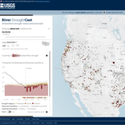
Where Can I Access or Download River DroughtCast Data? Where Can I Access or Download River DroughtCast Data?
To download data on past streamflow percentiles and droughts, please refer to this recent USGS article in Water Resource Research. Weekly streamflow drought observations, along with meteorological data and other factors used in forecasting models can be found at: https://doi.org/10.5066/P1X5VH96. In addition, the daily streamflow drought forecasts can be downloaded in parquet format from the River...

Can the USGS analyze my rock/water/soil sample? Can the USGS analyze my rock/water/soil sample?
The USGS has over 500 laboratories, but most of them only conduct research in support of the USGS mission. A small number offer laboratory services to other government agencies, partners, and collaborators. An even smaller number will process samples (for a fee) for the general public. Contact individual laboratories directly to ask what services they provide. Labs that accept samples from the...

Does the USGS have data on PFAS in drinking water? Does the USGS have data on PFAS in drinking water?
Use the USGS PFAS in US Tapwater interactive Dashboard to find PFAS data for drinking water. Instructions are on the website or watch a short video about the dashboard. The dashboard incorporates data from several USGS reports that cover PFAS in water sources, including community water supplies. Some notable studies and datasets that were used for the dashboard include: Per- and polyfluoroalkyl...

Why doesn’t USGS measure gage height from the bottom of the stream? Why doesn’t USGS measure gage height from the bottom of the stream?
Streams are like living things and are constantly changing. Sometimes streams erode, becoming deeper, while other times streams deposit sediment, becoming shallower. To understand how those changes can affect streamflow, we need to measure from a reference point that does not change over time, which is why gage datums are chosen to be below the base of a streambed. This means that the gage datum...

What are PFAS? What are PFAS?
Perfluoroalkyl and Polyfluoroalkyl Substances, or PFAS, are a group of synthetic chemicals used in a wide variety of common applications, from the linings of fast-food boxes and non-stick cookware to fire-fighting foams and other purposes. Their persistence in the environment and occurrence across the country make them a unique water quality concern. Drinking water quality and potential exposures...

How do I find the best place to drill for water on my property? How do I find the best place to drill for water on my property?
Many factors must be considered before deciding where to drill a water well. The most important is to decide how the well will be used. If the well is for drinking water, then local geology, hydrology, and state regulations are important to know. Contact the department in your state government that regulates and tracks water and natural resources. They should have information on licensed drillers...

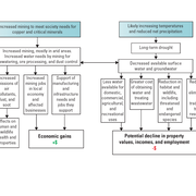
Can a drought be relieved by bringing in water from other regions of the country that have excess water? Can a drought be relieved by bringing in water from other regions of the country that have excess water?
Any large-scale projects for mitigating drought in the U.S. would fall under the direction of the Bureau of Reclamation, which is the federal agency tasked with water management. While technically feasible, transporting surface water from flood areas (or the ocean) to drought areas faces many challenges including water rights, property rights, environmental impacts, and more. Then there's the...

How can I find the HUC (Hydrologic Unit Code) for a stream? How can I find the name/location of a stream using the HUC? How can I find the HUC (Hydrologic Unit Code) for a stream? How can I find the name/location of a stream using the HUC?
Hydrologic Units (HUs) represent the area of the landscape that drains to a portion of the stream network. Each drainage has a unique Hydrologic Unit Code (HUC). The most current national HU dataset is the Watershed Boundary Dataset (WBD). HUCs from other sources might be out of date or differ from the WBD standards. The WBD includes six required levels of nested HU polygons (2- to 12-digit), two...

Can the USGS install a streamgage at my location? Can the USGS install a streamgage at my location?
The USGS can install a streamgage almost anywhere, but in most cases we do not choose when and where to do that. We typically install and operate streamgages where other entities ask and reimburse us to do so. We operate streamgages for entities such as cities, towns, counties, state agencies, and other federal agencies to assist with their missions and to provide data for general public use...