
This webinar was conducted as part of the Climate Change Science and Management Webinar Series, co-hosted by the USGS National Climate Change and Wildlife Science Center and the FWS National Conservation Training Center.
How many sinkholes open up in a year?
There is no database of sinkhole collapses for the United States, so these data are unavailable. Some individual state geologic surveys track reported collapses within their state. Many sinkhole collapses are not reported to authorities or news organizations, and many occur in rural areas where they are unobserved.
Learn more:
Related

Why are there no entries for caves in the Geographic Names Information System database? Why are there no entries for caves in the Geographic Names Information System database?
Geographic Names Information System (GNIS) does include caves but the entries are not publicly available. In response to the 1988 National Cave Management Resources Act, Department of the Interior Regulation 43 (CFR Subtitle A, Part 37) forbids the release of information regarding the location of all caves on Federal lands. Currently, GNIS does not distinguish between features on Federal versus...

How much does sinkhole damage cost each year in the United States? How much does sinkhole damage cost each year in the United States?
Sinkhole damages over the last 15 years cost on average at least \$300 million per year. Since there is no national tracking of sinkhole damage costs, this estimate is probably much lower than the actual cost. Learn more: USGS Water Science School - Sinkholes Karst Map of the Conterminous United States - 2020

What is a sinkhole? What is a sinkhole?
A sinkhole is a depression in the ground that has no natural external surface drainage. Basically, this means that when it rains, all of the water stays inside the sinkhole and typically drains into the subsurface. Sinkholes are most common in what geologists call, “ karst terrain.” These are regions where the types of rock below the land surface can naturally be dissolved by groundwater...

What is the difference between a sinkhole and a pothole? What is the difference between a sinkhole and a pothole?
A sinkhole is a closed natural depression in the ground surface caused by removal of material below the ground and either collapse or gradual subsidence of the surface into the resulting void. A pothole is usually a fairly small feature caused by failure of paving materials, usually associated with roads, parking lots, and airports. In the colder parts of the country, potholes become more abundant...

What is the difference between a sinkhole and land subsidence? What is the difference between a sinkhole and land subsidence?
Sinkholes are just one of many forms of ground collapse, or subsidence. Land subsidence is a gradual settling or sudden sinking of the Earth’s surface owing to subsurface movement of earth materials. The principal causes of land subsidence are aquifer-system compaction, drainage of organic soils, underground mining, hydrocompaction, natural compaction, sinkholes, and thawing permafrost. Land...

What is the largest sinkhole in the United States? What is the largest sinkhole in the United States?
There are some very large, ancient, ‘inactive’ sinkholes in some areas of the U.S. that are thousands of years old. Alabama claims to have the largest recent collapse sinkhole. It is called the “Golly Hole” and is located in Shelby County in the central part of the state. It collapsed suddenly in 1972. The sinkhole is about 325 feet long, 300 feet wide, and 120 feet deep. Learn more: USGS Water...

Karst, Critters, and Climate Change
This webinar was conducted as part of the Climate Change Science and Management Webinar Series, co-hosted by the USGS National Climate Change and Wildlife Science Center and the FWS National Conservation Training Center.

An Unseen World Beneath Our Feet - Caves, Sinkholes and Springs
An Unseen World Beneath Our Feet - Caves, Sinkholes and SpringsRandall Orndorff, Director of the Eastern Geology and Paleoclimate Science Center, discusses how Karst affects daily life. Beneath a quarter of the United States are rock types that can dissolve to form caves, sinkholes and other features. Nearly every state has rock layers of limestone, gypsum, and other soluble rocks we call ‘karst’.

Sinkholes in West-central Florida, Freeze Event of 2010
Sinkholes in West-central Florida, Freeze Event of 2010Cracks shown here in the exterior and supporting structures of this home are indicative of subsidence damage associated with sinkhole activity.
Sinkholes in West-central Florida, Freeze Event of 2010
Sinkholes in West-central Florida, Freeze Event of 2010Cracks shown here in the exterior and supporting structures of this home are indicative of subsidence damage associated with sinkhole activity.

Sinkholes in West-central Florida, Freeze Event of 2010
Sinkholes in West-central Florida, Freeze Event of 2010The entire root perimeter of this tree collapsed in response to subsidence activity. More than 110 sinkholes formed in the Dover area of Florida during a freeze event in January 2010. Ground water levels dropped to record-setting lows as farmers pumped water to irrigate their plants for protection from the cold temperatures.

Sinkholes in West-central Florida, Freeze Event of 2010
Sinkholes in West-central Florida, Freeze Event of 2010More than 110 sinkholes formed in the Dover area of Florida during a freeze event in January 2010. Ground water levels dropped to record-setting lows as farmers pumped water to irrigate their plants for protection from the cold temperatures. The sinkholes destroyed homes, roads and sections of cultivated areas.

Sinkhole Activity Damages Home.
Cracking along exterior walls is a sign of subsidence activity. Such severe structural damage from sinkholes can destroy homes and other structures.
Cracking along exterior walls is a sign of subsidence activity. Such severe structural damage from sinkholes can destroy homes and other structures.

Sinkholes in West-central Florida, Freeze Event of 2010
Sinkholes in West-central Florida, Freeze Event of 2010More than 110 sinkholes formed in the Dover area of Florida during a freeze event in January 2010. Ground water levels dropped to record-setting lows as farmers pumped water to irrigate their plants for protection from the cold temperatures. The sinkholes destroyed homes, roads and sections of cultivated areas.

Various Karst Features Along Peace River, Fl
Cypress Root Sink is also part of the Wabash Complex.
Cypress Root Sink is also part of the Wabash Complex.

What are sinkholes?
Listen to hear the answer.

What's Up With Sinkholes?
A huge sinkhole in Texas begs a few questions about this fascinating and sometimes hazardous phenomenon, so we sit down with USGS geologist Randy Orndorff to learn more.
A huge sinkhole in Texas begs a few questions about this fascinating and sometimes hazardous phenomenon, so we sit down with USGS geologist Randy Orndorff to learn more.

Various Karst Features Along Peace River, Fl
Inflow hole, left of staff gage, along the bottom wall of Dover Sink.
Inflow hole, left of staff gage, along the bottom wall of Dover Sink.

Various Karst Features Along Peace River, Fl
Monitoring levels at Gator Sink.

Various Karst Features Along Peace River, Fl
Root filled cavities near Catacombs No. 8 showing underground flow.
Root filled cavities near Catacombs No. 8 showing underground flow.

Winter Park Florida Sinkhole of 1981
Photo 2 of 15: Cars and house in a sinkhole. Auto mechanic’s garage intact. View to south across the sinkhole.
Photo 2 of 15: Cars and house in a sinkhole. Auto mechanic’s garage intact. View to south across the sinkhole.

Winter Park Florida Sinkhole of 1981
Photo 5 of 15: House in a sinkhole. View to east across the sinkhole.
Photo 5 of 15: House in a sinkhole. View to east across the sinkhole.

Winter Park Florida Sinkhole of 1981
Photo 7 of 15: Cars in a sinkhole. Auto mechanic’s garage starting to collapse into sinkhole. View to south across the sinkhole.
Photo 7 of 15: Cars in a sinkhole. Auto mechanic’s garage starting to collapse into sinkhole. View to south across the sinkhole.

Winter Park Florida Sinkhole of 1981
Photo 9 of 15: Community pool collapsing into sinkhole at. Pool was roughly Olympic-sized and was about half full at the time of collapse. Impressive sounds of the rebar and concrete snapping, then the rush of water. View to north across the sinkhole. (1:30 p.m)
Photo 9 of 15: Community pool collapsing into sinkhole at. Pool was roughly Olympic-sized and was about half full at the time of collapse. Impressive sounds of the rebar and concrete snapping, then the rush of water. View to north across the sinkhole. (1:30 p.m)
Sinkhole in Frederick, Maryland
Cover-collapse sinkhole in limestone near Frederick, Maryland (September 2003). Many sinkholes occur along highways where rainwater runoff is concentrated into storm drains and ditches increasing the rate of sinkhole development (note the sewer drain pipe beneath roadway).
Cover-collapse sinkhole in limestone near Frederick, Maryland (September 2003). Many sinkholes occur along highways where rainwater runoff is concentrated into storm drains and ditches increasing the rate of sinkhole development (note the sewer drain pipe beneath roadway).
Related
Why are there no entries for caves in the Geographic Names Information System database? Why are there no entries for caves in the Geographic Names Information System database?
Geographic Names Information System (GNIS) does include caves but the entries are not publicly available. In response to the 1988 National Cave Management Resources Act, Department of the Interior Regulation 43 (CFR Subtitle A, Part 37) forbids the release of information regarding the location of all caves on Federal lands. Currently, GNIS does not distinguish between features on Federal versus...
How much does sinkhole damage cost each year in the United States? How much does sinkhole damage cost each year in the United States?
Sinkhole damages over the last 15 years cost on average at least \$300 million per year. Since there is no national tracking of sinkhole damage costs, this estimate is probably much lower than the actual cost. Learn more: USGS Water Science School - Sinkholes Karst Map of the Conterminous United States - 2020
What is a sinkhole? What is a sinkhole?
A sinkhole is a depression in the ground that has no natural external surface drainage. Basically, this means that when it rains, all of the water stays inside the sinkhole and typically drains into the subsurface. Sinkholes are most common in what geologists call, “ karst terrain.” These are regions where the types of rock below the land surface can naturally be dissolved by groundwater...
What is the difference between a sinkhole and a pothole? What is the difference between a sinkhole and a pothole?
A sinkhole is a closed natural depression in the ground surface caused by removal of material below the ground and either collapse or gradual subsidence of the surface into the resulting void. A pothole is usually a fairly small feature caused by failure of paving materials, usually associated with roads, parking lots, and airports. In the colder parts of the country, potholes become more abundant...
What is the difference between a sinkhole and land subsidence? What is the difference between a sinkhole and land subsidence?
Sinkholes are just one of many forms of ground collapse, or subsidence. Land subsidence is a gradual settling or sudden sinking of the Earth’s surface owing to subsurface movement of earth materials. The principal causes of land subsidence are aquifer-system compaction, drainage of organic soils, underground mining, hydrocompaction, natural compaction, sinkholes, and thawing permafrost. Land...
What is the largest sinkhole in the United States? What is the largest sinkhole in the United States?
There are some very large, ancient, ‘inactive’ sinkholes in some areas of the U.S. that are thousands of years old. Alabama claims to have the largest recent collapse sinkhole. It is called the “Golly Hole” and is located in Shelby County in the central part of the state. It collapsed suddenly in 1972. The sinkhole is about 325 feet long, 300 feet wide, and 120 feet deep. Learn more: USGS Water...
Karst, Critters, and Climate Change
This webinar was conducted as part of the Climate Change Science and Management Webinar Series, co-hosted by the USGS National Climate Change and Wildlife Science Center and the FWS National Conservation Training Center.
This webinar was conducted as part of the Climate Change Science and Management Webinar Series, co-hosted by the USGS National Climate Change and Wildlife Science Center and the FWS National Conservation Training Center.
An Unseen World Beneath Our Feet - Caves, Sinkholes and Springs
An Unseen World Beneath Our Feet - Caves, Sinkholes and SpringsRandall Orndorff, Director of the Eastern Geology and Paleoclimate Science Center, discusses how Karst affects daily life. Beneath a quarter of the United States are rock types that can dissolve to form caves, sinkholes and other features. Nearly every state has rock layers of limestone, gypsum, and other soluble rocks we call ‘karst’.
Sinkholes in West-central Florida, Freeze Event of 2010
Sinkholes in West-central Florida, Freeze Event of 2010Cracks shown here in the exterior and supporting structures of this home are indicative of subsidence damage associated with sinkhole activity.
Sinkholes in West-central Florida, Freeze Event of 2010
Sinkholes in West-central Florida, Freeze Event of 2010Cracks shown here in the exterior and supporting structures of this home are indicative of subsidence damage associated with sinkhole activity.
Sinkholes in West-central Florida, Freeze Event of 2010
Sinkholes in West-central Florida, Freeze Event of 2010The entire root perimeter of this tree collapsed in response to subsidence activity. More than 110 sinkholes formed in the Dover area of Florida during a freeze event in January 2010. Ground water levels dropped to record-setting lows as farmers pumped water to irrigate their plants for protection from the cold temperatures.
Sinkholes in West-central Florida, Freeze Event of 2010
Sinkholes in West-central Florida, Freeze Event of 2010More than 110 sinkholes formed in the Dover area of Florida during a freeze event in January 2010. Ground water levels dropped to record-setting lows as farmers pumped water to irrigate their plants for protection from the cold temperatures. The sinkholes destroyed homes, roads and sections of cultivated areas.
Sinkhole Activity Damages Home.
Cracking along exterior walls is a sign of subsidence activity. Such severe structural damage from sinkholes can destroy homes and other structures.
Cracking along exterior walls is a sign of subsidence activity. Such severe structural damage from sinkholes can destroy homes and other structures.
Sinkholes in West-central Florida, Freeze Event of 2010
Sinkholes in West-central Florida, Freeze Event of 2010More than 110 sinkholes formed in the Dover area of Florida during a freeze event in January 2010. Ground water levels dropped to record-setting lows as farmers pumped water to irrigate their plants for protection from the cold temperatures. The sinkholes destroyed homes, roads and sections of cultivated areas.
Various Karst Features Along Peace River, Fl
Cypress Root Sink is also part of the Wabash Complex.
Cypress Root Sink is also part of the Wabash Complex.
What are sinkholes?
Listen to hear the answer.
What's Up With Sinkholes?
A huge sinkhole in Texas begs a few questions about this fascinating and sometimes hazardous phenomenon, so we sit down with USGS geologist Randy Orndorff to learn more.
A huge sinkhole in Texas begs a few questions about this fascinating and sometimes hazardous phenomenon, so we sit down with USGS geologist Randy Orndorff to learn more.
Various Karst Features Along Peace River, Fl
Inflow hole, left of staff gage, along the bottom wall of Dover Sink.
Inflow hole, left of staff gage, along the bottom wall of Dover Sink.
Various Karst Features Along Peace River, Fl
Monitoring levels at Gator Sink.
Various Karst Features Along Peace River, Fl
Root filled cavities near Catacombs No. 8 showing underground flow.
Root filled cavities near Catacombs No. 8 showing underground flow.
Winter Park Florida Sinkhole of 1981
Photo 2 of 15: Cars and house in a sinkhole. Auto mechanic’s garage intact. View to south across the sinkhole.
Photo 2 of 15: Cars and house in a sinkhole. Auto mechanic’s garage intact. View to south across the sinkhole.
Winter Park Florida Sinkhole of 1981
Photo 5 of 15: House in a sinkhole. View to east across the sinkhole.
Photo 5 of 15: House in a sinkhole. View to east across the sinkhole.
Winter Park Florida Sinkhole of 1981
Photo 7 of 15: Cars in a sinkhole. Auto mechanic’s garage starting to collapse into sinkhole. View to south across the sinkhole.
Photo 7 of 15: Cars in a sinkhole. Auto mechanic’s garage starting to collapse into sinkhole. View to south across the sinkhole.
Winter Park Florida Sinkhole of 1981
Photo 9 of 15: Community pool collapsing into sinkhole at. Pool was roughly Olympic-sized and was about half full at the time of collapse. Impressive sounds of the rebar and concrete snapping, then the rush of water. View to north across the sinkhole. (1:30 p.m)
Photo 9 of 15: Community pool collapsing into sinkhole at. Pool was roughly Olympic-sized and was about half full at the time of collapse. Impressive sounds of the rebar and concrete snapping, then the rush of water. View to north across the sinkhole. (1:30 p.m)
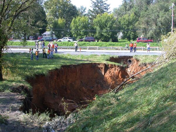
Sinkhole in Frederick, Maryland
Cover-collapse sinkhole in limestone near Frederick, Maryland (September 2003). Many sinkholes occur along highways where rainwater runoff is concentrated into storm drains and ditches increasing the rate of sinkhole development (note the sewer drain pipe beneath roadway).
Cover-collapse sinkhole in limestone near Frederick, Maryland (September 2003). Many sinkholes occur along highways where rainwater runoff is concentrated into storm drains and ditches increasing the rate of sinkhole development (note the sewer drain pipe beneath roadway).
Updated Date: February 4, 2025