
GOES-West image of the explosive eruption of the Hunga Tonga volcano in 2022. The explosion atmospheric pressure waves that traveled around the world. Read more here.
What is a supervolcano? What is a supereruption?
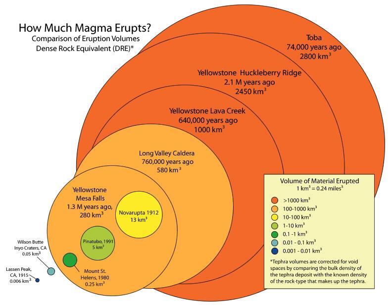
The term "supervolcano" implies a volcanic center that has had an eruption of magnitude 8 on the Volcano Explosivity Index (VEI), meaning that at one point in time it erupted more than 1,000 cubic kilometers (240 cubic miles) of material. In the early 2000s, the term “supereruption” began being used as a catchy way to describe VEI 8 eruptions. Explosive events of this size erupt so much magma that a circular-shaped collapse feature, called a caldera, forms above the evacuated magma storage region.
The largest eruption at Yellowstone was 2.1 million years ago and had a volume of 2,450 cubic kilometers. Like many other caldera-forming volcanoes, most of Yellowstone’s many eruptions have been smaller than VEI 8 supereruptions, so it is confusing to categorize Yellowstone as a “supervolcano.”
Other caldera-forming volcanoes that have produced exceedingly large pyroclastic eruptions in the past 2 million years include Long Valley in eastern California, Valles Caldera in New Mexico, Toba in Indonesia, and Taupo in New Zealand. Taupo erupted 22,600 years ago and is the most recent supereruption on Earth (with a volume of about 1,130 cubic kilometers).
Additional volcanoes capable of producing supereruptions include the large caldera volcanoes of Japan, Indonesia, and South America.
Learn more:
- Caldera systems--a worldwide family that is more than just Yellowstone!
- A personal commentary: Why I dislike the tern "supervolcano" (and what we should be saying instead)
Media
Sources/Usage: Public Domain. View Media Details
Related

How many active volcanoes are there on Earth? How many active volcanoes are there on Earth?
There are about 1,350 potentially active volcanoes worldwide, aside from the continuous belts of volcanoes on the ocean floor at spreading centers like the Mid-Atlantic Ridge. About 500 of those 1,350 volcanoes have erupted in historical time. Many of those are located along the Pacific Rim in what is known as the " Ring of Fire." In the United States, volcanoes in the Cascade Range and Alaska...

What are some examples of supervolcanoes? What are some examples of supervolcanoes?
Volcanoes that have produced exceedingly voluminous pyroclastic eruptions and formed large calderas in the past 2 million years include Yellowstone in northwest Wyoming, Long Valley in eastern California, Toba in Indonesia, and Taupo in New Zealand. Other 'supervolcanoes' would likely include the large caldera volcanoes of Japan, Indonesia, Alaska (e.g. Aniakchak, Emmons, Fisher), and other areas...

What was the most destructive volcanic eruption in the history of the United States? What was the most destructive volcanic eruption in the history of the United States?
The May 18, 1980 eruption of Mount St. Helens (Washington) was the most destructive in the history of the United States. Novarupta (Katmai) Volcano in Alaska erupted considerably more material in 1912, but owing to the isolation and sparse population of the region, there were no human deaths and little property damage. In contrast, the eruption of Mount St. Helens caused loss of lives and...

Where does the United States rank in the number of volcanoes? Where does the United States rank in the number of volcanoes?
The United States ranks third, behind Indonesia and Japan, in the number of historically active volcanoes (that is, those for which we have written accounts of eruptions). In addition, about 10 percent of the more than 1,500 volcanoes that have erupted in the past 10,000 years are located in the United States. Most of these volcanoes are found in the Aleutian Islands, the Alaska Peninsula, the...

Where is the largest active volcano in the world? Where is the largest active volcano in the world?
Rising gradually to more than 4 km (2.5 mi) above sea level, Hawaii’s Mauna Loa is the largest active volcano on our planet. Its submarine flanks descend to the sea floor an additional 5 km (3 mi), and the sea floor in turn is depressed by Mauna Loa's great mass another 8 km (5 mi). This makes the volcano's summit about 17 km (10.5 mi) above its base! Learn more: USGS Hawaiian Volcano Observatory

What was the largest volcanic eruption in the 20th century? What was the largest volcanic eruption in the 20th century?
The world's largest eruption of the 20th century occurred in 1912 at Novarupta on the Alaska Peninsula in what is now Katmai National Park and Preserve. An estimated 15 cubic kilometers of magma was explosively erupted during 60 hours beginning on June 6th. This volume is equivalent to 230 years of eruption at Kilauea (Hawaii) or about 30 times the volume erupted by Mount St. Helens (Washington)...

Is Yellowstone overdue for an eruption? When will Yellowstone erupt? Is Yellowstone overdue for an eruption? When will Yellowstone erupt?
Yellowstone is not overdue for an eruption. Volcanoes do not work in predictable ways and their eruptions do not follow predictable schedules. Even so, the math doesn’t work out for the volcano to be “overdue” for an eruption. In terms of large explosions, Yellowstone has experienced three at 2.08, 1.3, and 0.631 million years ago. This comes out to an average of about 725,000 years between...

What type of eruption will Yellowstone have if it erupts again? What type of eruption will Yellowstone have if it erupts again?
The most likely explosive event to occur at Yellowstone is actually a hydrothermal explosion (a rock hurling geyser eruption) or a lava flow. Hydrothermal explosions are very small; they occur in Yellowstone National Park every few years and form a crater a few meters across. Every few thousand years, a hydrothermal explosion will form a crater as much as a few hundred meters across. Though the...

Hunga Tonga Volcano Ash Plume
GOES-West image of the explosive eruption of the Hunga Tonga volcano in 2022. The explosion atmospheric pressure waves that traveled around the world. Read more here.

Schematic showing collapse processes of Yellowstone Caldera
Schematic showing collapse processes of Yellowstone CalderaSchematic displaying the general processes associated with collapse of Yellowstone Caldera. (A) Pre-caldera volcanism includes the eruption of dome complexes from the underlying magma chambers. (B) The caldera-forming eruption evacuates a significant amount of magma from the chamber, causing the overlying crustal block to subside into the void space.&nbs

Obsidian Cliff lava flow, Yellowstone
Photograph of Obsidian Cliff along Grand Loop Road between Norris and Mammoth Hot Springs. Photograph by John Good, U.S. National Park Service, 1965.
Photograph of Obsidian Cliff along Grand Loop Road between Norris and Mammoth Hot Springs. Photograph by John Good, U.S. National Park Service, 1965.

Inside USGS, No. 6, Ken Pierce, Heavy Breathing of Yellowstone Caldera
Inside USGS, No. 6, Ken Pierce, Heavy Breathing of Yellowstone CalderaDr. Kenneth Pierce studied the geology and geomorphology of the greater Yellowstone area for nearly his entire career with the U.S. Geological Survey. From 1965 to present, Dr.

Forecasting Ashfall Impacts from a Yellowstone Supereruption
Forecasting Ashfall Impacts from a Yellowstone Supereruption- Yellowstone is one of a few dozen volcanoes on earth capable of "supereruptions" that expel more than 1,000 cubic km of ash and debris.
- The plumes from such eruptions can rise 30 to 50 km into the atmosphere, three to five times as high as most jets fly.

Caldera Demonstration Model
A caldera is a large, usually circular volcanic depression formed when magma is withdrawn or erupted from a shallow underground magma reservoir. It is often difficult to visualize how calderas form. This simple experiment using flour, a balloon, tubing, and a bicycle pump, provides a helpful visualization for caldera formation.
A caldera is a large, usually circular volcanic depression formed when magma is withdrawn or erupted from a shallow underground magma reservoir. It is often difficult to visualize how calderas form. This simple experiment using flour, a balloon, tubing, and a bicycle pump, provides a helpful visualization for caldera formation.

Columnar-jointed lava flow in the wall of the Yellowstone River canyon
Columnar-jointed lava flow in the wall of the Yellowstone River canyonA 1.5-million-year-old basaltic lava flow in the canyon wall of the Yellowstone River as viewed from Calcite Springs Overlook near Tower Junction in Yellowstone National Park. Slow cooling of this lava flow resulted in the formation of vertical columns. Glacial gravels are present above and below the lava flow.

The June 12, 1991 eruption column from Mount Pinatubo taken from th...
The June 12, 1991 eruption column from Mount Pinatubo taken from th...The June 12, 1991 eruption column from Mount Pinatubo taken from the east side of Clark Air Base.
The June 12, 1991 eruption column from Mount Pinatubo taken from th...
The June 12, 1991 eruption column from Mount Pinatubo taken from th...The June 12, 1991 eruption column from Mount Pinatubo taken from the east side of Clark Air Base.
Related
How many active volcanoes are there on Earth? How many active volcanoes are there on Earth?
There are about 1,350 potentially active volcanoes worldwide, aside from the continuous belts of volcanoes on the ocean floor at spreading centers like the Mid-Atlantic Ridge. About 500 of those 1,350 volcanoes have erupted in historical time. Many of those are located along the Pacific Rim in what is known as the " Ring of Fire." In the United States, volcanoes in the Cascade Range and Alaska...
What are some examples of supervolcanoes? What are some examples of supervolcanoes?
Volcanoes that have produced exceedingly voluminous pyroclastic eruptions and formed large calderas in the past 2 million years include Yellowstone in northwest Wyoming, Long Valley in eastern California, Toba in Indonesia, and Taupo in New Zealand. Other 'supervolcanoes' would likely include the large caldera volcanoes of Japan, Indonesia, Alaska (e.g. Aniakchak, Emmons, Fisher), and other areas...
What was the most destructive volcanic eruption in the history of the United States? What was the most destructive volcanic eruption in the history of the United States?
The May 18, 1980 eruption of Mount St. Helens (Washington) was the most destructive in the history of the United States. Novarupta (Katmai) Volcano in Alaska erupted considerably more material in 1912, but owing to the isolation and sparse population of the region, there were no human deaths and little property damage. In contrast, the eruption of Mount St. Helens caused loss of lives and...
Where does the United States rank in the number of volcanoes? Where does the United States rank in the number of volcanoes?
The United States ranks third, behind Indonesia and Japan, in the number of historically active volcanoes (that is, those for which we have written accounts of eruptions). In addition, about 10 percent of the more than 1,500 volcanoes that have erupted in the past 10,000 years are located in the United States. Most of these volcanoes are found in the Aleutian Islands, the Alaska Peninsula, the...
Where is the largest active volcano in the world? Where is the largest active volcano in the world?
Rising gradually to more than 4 km (2.5 mi) above sea level, Hawaii’s Mauna Loa is the largest active volcano on our planet. Its submarine flanks descend to the sea floor an additional 5 km (3 mi), and the sea floor in turn is depressed by Mauna Loa's great mass another 8 km (5 mi). This makes the volcano's summit about 17 km (10.5 mi) above its base! Learn more: USGS Hawaiian Volcano Observatory
What was the largest volcanic eruption in the 20th century? What was the largest volcanic eruption in the 20th century?
The world's largest eruption of the 20th century occurred in 1912 at Novarupta on the Alaska Peninsula in what is now Katmai National Park and Preserve. An estimated 15 cubic kilometers of magma was explosively erupted during 60 hours beginning on June 6th. This volume is equivalent to 230 years of eruption at Kilauea (Hawaii) or about 30 times the volume erupted by Mount St. Helens (Washington)...
Is Yellowstone overdue for an eruption? When will Yellowstone erupt? Is Yellowstone overdue for an eruption? When will Yellowstone erupt?
Yellowstone is not overdue for an eruption. Volcanoes do not work in predictable ways and their eruptions do not follow predictable schedules. Even so, the math doesn’t work out for the volcano to be “overdue” for an eruption. In terms of large explosions, Yellowstone has experienced three at 2.08, 1.3, and 0.631 million years ago. This comes out to an average of about 725,000 years between...
What type of eruption will Yellowstone have if it erupts again? What type of eruption will Yellowstone have if it erupts again?
The most likely explosive event to occur at Yellowstone is actually a hydrothermal explosion (a rock hurling geyser eruption) or a lava flow. Hydrothermal explosions are very small; they occur in Yellowstone National Park every few years and form a crater a few meters across. Every few thousand years, a hydrothermal explosion will form a crater as much as a few hundred meters across. Though the...
Hunga Tonga Volcano Ash Plume
GOES-West image of the explosive eruption of the Hunga Tonga volcano in 2022. The explosion atmospheric pressure waves that traveled around the world. Read more here.
GOES-West image of the explosive eruption of the Hunga Tonga volcano in 2022. The explosion atmospheric pressure waves that traveled around the world. Read more here.
Schematic showing collapse processes of Yellowstone Caldera
Schematic showing collapse processes of Yellowstone CalderaSchematic displaying the general processes associated with collapse of Yellowstone Caldera. (A) Pre-caldera volcanism includes the eruption of dome complexes from the underlying magma chambers. (B) The caldera-forming eruption evacuates a significant amount of magma from the chamber, causing the overlying crustal block to subside into the void space.&nbs
Obsidian Cliff lava flow, Yellowstone
Photograph of Obsidian Cliff along Grand Loop Road between Norris and Mammoth Hot Springs. Photograph by John Good, U.S. National Park Service, 1965.
Photograph of Obsidian Cliff along Grand Loop Road between Norris and Mammoth Hot Springs. Photograph by John Good, U.S. National Park Service, 1965.
Inside USGS, No. 6, Ken Pierce, Heavy Breathing of Yellowstone Caldera
Inside USGS, No. 6, Ken Pierce, Heavy Breathing of Yellowstone CalderaDr. Kenneth Pierce studied the geology and geomorphology of the greater Yellowstone area for nearly his entire career with the U.S. Geological Survey. From 1965 to present, Dr.
Forecasting Ashfall Impacts from a Yellowstone Supereruption
Forecasting Ashfall Impacts from a Yellowstone Supereruption- Yellowstone is one of a few dozen volcanoes on earth capable of "supereruptions" that expel more than 1,000 cubic km of ash and debris.
- The plumes from such eruptions can rise 30 to 50 km into the atmosphere, three to five times as high as most jets fly.
Caldera Demonstration Model
A caldera is a large, usually circular volcanic depression formed when magma is withdrawn or erupted from a shallow underground magma reservoir. It is often difficult to visualize how calderas form. This simple experiment using flour, a balloon, tubing, and a bicycle pump, provides a helpful visualization for caldera formation.
A caldera is a large, usually circular volcanic depression formed when magma is withdrawn or erupted from a shallow underground magma reservoir. It is often difficult to visualize how calderas form. This simple experiment using flour, a balloon, tubing, and a bicycle pump, provides a helpful visualization for caldera formation.
Columnar-jointed lava flow in the wall of the Yellowstone River canyon
Columnar-jointed lava flow in the wall of the Yellowstone River canyonA 1.5-million-year-old basaltic lava flow in the canyon wall of the Yellowstone River as viewed from Calcite Springs Overlook near Tower Junction in Yellowstone National Park. Slow cooling of this lava flow resulted in the formation of vertical columns. Glacial gravels are present above and below the lava flow.
The June 12, 1991 eruption column from Mount Pinatubo taken from th...
The June 12, 1991 eruption column from Mount Pinatubo taken from th...The June 12, 1991 eruption column from Mount Pinatubo taken from the east side of Clark Air Base.
The June 12, 1991 eruption column from Mount Pinatubo taken from th...
The June 12, 1991 eruption column from Mount Pinatubo taken from th...The June 12, 1991 eruption column from Mount Pinatubo taken from the east side of Clark Air Base.
Updated Date: June 3, 2026