
In a September 21, 1966 press release, Secretary of the Interior Stewart Udall announced that the DOI was launching "Project EROS (Earth Resources Observation Satellites)." Udall's vision was to observe the Earth for the benefit of all.
What sensors does the Landsat 9 satellite carry?
Landsat 9 carries the same instruments that are on the Landsat 8 satellite but with some improvements:
-
Operational Land Imager (OLI) for reflective band data.
-
Thermal Infrared Sensor (TIRS) for the thermal infrared bands.
-
OLI has a slightly improved signal-to-noise ratio over Landsat 8's OLI.
-
Landsat 9’s TIRS is a Class-B instrument with a five-year design life and a key improvement of stray light correction, an issue that was discovered on Landsat 8’s TIRS (Landsat 8's TIRS is a Class-C instrument with a three-year design life).
-
As with Landsat 8, Landsat 9 has higher imaging capacity than previous Landsat missions, allowing for more valuable Earth observations to be added into the USGS Landsat archive.
Learn more: Landsat 9 Mission
Related

When was the Landsat 9 satellite launched? When was the Landsat 9 satellite launched?
Landsat 9—a partnership between the USGS and NASA—was launched from Space Launch Complex 3E at Vandenberg Air Force Base in California upon a United Launch Alliance Atlas V 401 launch vehicle on September 27, 2021. Learn more: Landsat 9 Mission

How do I search for and download Landsat data? How do I search for and download Landsat data?
Landsat data products held in the USGS archives can be searched and downloaded at no charge from a variety of sources. Visit Landsat Data Access for information about how Landsat data products can be downloaded individually or in bulk. Landsat imagery not found in the USGS archive might have been collected by one of the USGS International Cooperator ground stations, each of which are the primary...

How do I open Landsat satellite data files? How do I open Landsat satellite data files?
Many image processing programs can handle GeoTIFF and Cloud optimized GeoTIFF (COG) Landsat files, including free software like Multispec and QGIS. To view Landsat scenes without using specialized software, download Landsat Full Resolution browse images (.jpg) from EarthExplorer or GloVis. * The USGS does NOT endorse or support specific software packages. Any usability questions relating to...

What are the best Landsat spectral bands for use in my research? What are the best Landsat spectral bands for use in my research?
The Spectral Characteristics Viewer is an interactive tool that can be used to visualize how the bands, or channels, of different satellite sensors measure the intensity of the many wavelengths (colors) of light. This is also known as the relative spectral response (RSR). By overlaying the spectral curves from different features (spectra), one can determine which bands of the selected sensor will...

After a Landsat scene is collected, when will it become available for search and download? After a Landsat scene is collected, when will it become available for search and download?
Landsat scenes become available through EarthExplorer within 6 hours after acquisition and become visible in GloVis within 24 hours. See Landsat Acquisitions for acquisition calendars and information about daily schedules.

What is the Landsat satellite program and why is it important? What is the Landsat satellite program and why is it important?
The Landsat Program is a series of Earth-observing satellite missions jointly managed by NASA and the U.S. Geological Survey. On July 23, 1972, in cooperation with NASA, the Earth Resources Technology Satellite (ERTS-1) was launched. It was later renamed Landsat 1. Additional Landsat satellites have launched to bring the world an archive of remote sensing data. Currently orbiting and active...

What are Landsat Collections? What are Landsat Collections?
In 2016, the USGS reorganized the Landsat archive into a tiered collection. This structure ensures that Landsat Level-1 products provide a consistent archive of known data quality to support time-series analyses and data “stacking”, while controlling continuous improvement of the archive and access to all data as they are acquired. Learn more: Landsat Collections Landsat Data Access

What are U.S. Landsat Analysis Ready Data (ARD)? What are U.S. Landsat Analysis Ready Data (ARD)?
U.S. Landsat Analysis Ready Data (ARD) are pre-packaged and pre-processed bundles of Landsat data products that make the Landsat archive more accessible and easier to analyze, and reduce the amount of time users spend on data processing for time-series analysis. ARD contains Level-2 products derived from Landsat Collections Level-1 scenes. ARD are tiled, georegistered, top of atmosphere, and...
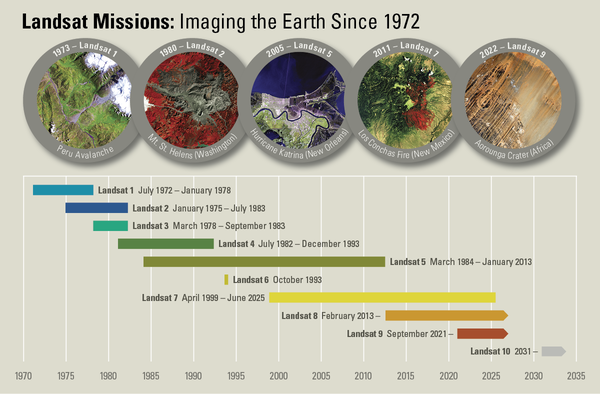
Landsat Missions Timeline
In a September 21, 1966 press release, Secretary of the Interior Stewart Udall announced that the DOI was launching "Project EROS (Earth Resources Observation Satellites)." Udall's vision was to observe the Earth for the benefit of all.
Related
When was the Landsat 9 satellite launched? When was the Landsat 9 satellite launched?
Landsat 9—a partnership between the USGS and NASA—was launched from Space Launch Complex 3E at Vandenberg Air Force Base in California upon a United Launch Alliance Atlas V 401 launch vehicle on September 27, 2021. Learn more: Landsat 9 Mission
How do I search for and download Landsat data? How do I search for and download Landsat data?
Landsat data products held in the USGS archives can be searched and downloaded at no charge from a variety of sources. Visit Landsat Data Access for information about how Landsat data products can be downloaded individually or in bulk. Landsat imagery not found in the USGS archive might have been collected by one of the USGS International Cooperator ground stations, each of which are the primary...
How do I open Landsat satellite data files? How do I open Landsat satellite data files?
Many image processing programs can handle GeoTIFF and Cloud optimized GeoTIFF (COG) Landsat files, including free software like Multispec and QGIS. To view Landsat scenes without using specialized software, download Landsat Full Resolution browse images (.jpg) from EarthExplorer or GloVis. * The USGS does NOT endorse or support specific software packages. Any usability questions relating to...
What are the best Landsat spectral bands for use in my research? What are the best Landsat spectral bands for use in my research?
The Spectral Characteristics Viewer is an interactive tool that can be used to visualize how the bands, or channels, of different satellite sensors measure the intensity of the many wavelengths (colors) of light. This is also known as the relative spectral response (RSR). By overlaying the spectral curves from different features (spectra), one can determine which bands of the selected sensor will...
After a Landsat scene is collected, when will it become available for search and download? After a Landsat scene is collected, when will it become available for search and download?
Landsat scenes become available through EarthExplorer within 6 hours after acquisition and become visible in GloVis within 24 hours. See Landsat Acquisitions for acquisition calendars and information about daily schedules.
What is the Landsat satellite program and why is it important? What is the Landsat satellite program and why is it important?
The Landsat Program is a series of Earth-observing satellite missions jointly managed by NASA and the U.S. Geological Survey. On July 23, 1972, in cooperation with NASA, the Earth Resources Technology Satellite (ERTS-1) was launched. It was later renamed Landsat 1. Additional Landsat satellites have launched to bring the world an archive of remote sensing data. Currently orbiting and active...
What are Landsat Collections? What are Landsat Collections?
In 2016, the USGS reorganized the Landsat archive into a tiered collection. This structure ensures that Landsat Level-1 products provide a consistent archive of known data quality to support time-series analyses and data “stacking”, while controlling continuous improvement of the archive and access to all data as they are acquired. Learn more: Landsat Collections Landsat Data Access
What are U.S. Landsat Analysis Ready Data (ARD)? What are U.S. Landsat Analysis Ready Data (ARD)?
U.S. Landsat Analysis Ready Data (ARD) are pre-packaged and pre-processed bundles of Landsat data products that make the Landsat archive more accessible and easier to analyze, and reduce the amount of time users spend on data processing for time-series analysis. ARD contains Level-2 products derived from Landsat Collections Level-1 scenes. ARD are tiled, georegistered, top of atmosphere, and...
Landsat Missions Timeline
In a September 21, 1966 press release, Secretary of the Interior Stewart Udall announced that the DOI was launching "Project EROS (Earth Resources Observation Satellites)." Udall's vision was to observe the Earth for the benefit of all.
In a September 21, 1966 press release, Secretary of the Interior Stewart Udall announced that the DOI was launching "Project EROS (Earth Resources Observation Satellites)." Udall's vision was to observe the Earth for the benefit of all.
Updated Date: April 6, 2026