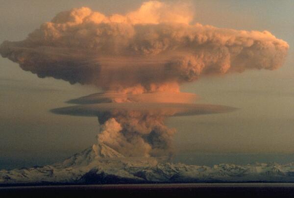
Steaming Pavlof volcano and Pavlof Sister as viewed from the west shore of Unga Island, Alaska. View is to the west.
Where can I find information about volcanoes in Alaska?
Alaska contains over 130 volcanoes and volcanic fields which have been active within the last two million years. Of these volcanoes more than 50 have been active within historical time (since about 1760, for Alaska).
Visit the Alaska Volcano Observatory (AVO) for information on Alaska Volcanoes. The Alaska Volcano Observatory (AVO) covers volcanoes in Alaska from offices in Anchorage and Fairbanks, Alaska, and is a cooperative program of the U.S. Geological Survey, the University of Alaska Fairbanks Geophysical Institute, and the Alaska Division of Geological and Geophysical Surveys.
Social media options include the USGS Volcanoes on Twitter
Related
How many volcanoes are in Alaska?
Alaska contains over 130 volcanoes and volcanic fields which have been active within the last two million years. Of these volcanoes, about 90 have been active within the last 10,000 years (and might be expected to erupt again), and more than 50 have been active within historical time (since about 1760, for Alaska). These volcanoes are catalogued on the Alaska Volcano Observatory Map & Alphabetical...
How often do Alaskan volcanoes erupt?
Alaskan volcanoes have produced one or two eruptions per year since 1900. At least 20 catastrophic caldera -forming eruptions have occurred in the past 10,000 years; the awesome eruption of 1912 at Novarupta in what is now Katmai National Park and Preserve is the most recent. Scientists are particularly concerned about the volcanoes whose eruptions can affect the Cook Inlet region, where 60...
What was the largest volcanic eruption in the 20th century?
The world's largest eruption of the 20th century occurred in 1912 at Novarupta on the Alaska Peninsula in what is now Katmai National Park and Preserve. An estimated 15 cubic kilometers of magma was explosively erupted during 60 hours beginning on June 6th. This volume is equivalent to 230 years of eruption at Kilauea (Hawaii) or about 30 times the volume erupted by Mount St. Helens (Washington)...
Steaming Pavlof volcano and Pavlof Sister as viewed from the west shore of Unga Island, Alaska. View is to the west.
-- a Centennial perspective of the Novarupta-Katmai eruption, the largest of the 20th century
By Judy Fierstein, USGS
-- a Centennial perspective of the Novarupta-Katmai eruption, the largest of the 20th century
By Judy Fierstein, USGS
Bill Burton discusses the June 6-8, 1912 eruption of Mount Katmai in Alaska which was 30 times larger than the eruption of Mt. St. Helens in 1980. This eruption caused widespread devastation, and inspired heroic efforts at survival by the local people.
USGS technologist Rick LaHusen describes how the development and deployment of instruments plays a crucial role in mitigating volcanic hazards.
-- the contrasting stories of two recent spectacular eruptions
by Stephanie Prejean, USGS Alaska Volcano Observatory
-- the contrasting stories of two recent spectacular eruptions
by Stephanie Prejean, USGS Alaska Volcano Observatory
Great Earthquakes, Great Waves, and Great Volcanic Explosions!
by Steve Kirby, Geophsicist, and Dave Scholl, Scientist Emeritus
Great Earthquakes, Great Waves, and Great Volcanic Explosions!
by Steve Kirby, Geophsicist, and Dave Scholl, Scientist Emeritus
Shishaldin Volcano at sunset. Shishaldin is on Unimak Island, part of Izembek National Wildlife Refuge, Alaska.
This photos was staged to simulate how scientists monitor data.
Redoubt volcano with minor ash eruption. Photograph taken during observation and gas data collection flight by AVO staff March 30, 2009.
A gas plume arising from Augustine Volcano during it's eruptive phase 2005-06. This photo was taken during a FLIR/maintenance flight on January 24, 2006.
Augustine volcano viewed from the west.
Roiling eruption column rising from Crater Peak vent of Mt. Spurr volcano. View from the south.
View southeast from Overlook Cabin looking over the Valley of Ten Thousand Smokes. The pyroclastic and ash deposits that fill the valley remain nearly vegetation-free more than 100 years after the 1912 Novarupta-Katmai eruption.
Ascending eruption cloud from Redoubt Volcano as viewed to the west from the Kenai Peninsula. The mushroom-shaped plume rose from avalanches of hot debris (pyroclastic flows) that cascaded down the north flank of the volcano. A smaller, white steam plume rises from the summit crater.
2018 Volcanic activity in Alaska—Summary of events and response of the Alaska Volcano Observatory
Alaska Volcano Observatory archive of seismic drum records of eruptions of Augustine Volcano (1986), Redoubt Volcano (1989–90), Mount Spurr (1992), and Pavlof Volcano (1996), and the 1996 earthquake swarm at Akutan Peak
2017 Volcanic activity in Alaska—Summary of events and response of the Alaska Volcano Observatory
2016 Volcanic activity in Alaska—Summary of events and response of the Alaska Volcano Observatory
A unified catalog of earthquake hypocenters and magnitudes at volcanoes in Alaska—1989 to 2018
Living with volcano hazards
2018 update to the U.S. Geological Survey national volcanic threat assessment
When erupting, all volcanoes pose a degree of risk to people and infrastructure, however, the risks are not equivalent from one volcano to another because of differences in eruptive style and geographic location. Assessing the relative threats posed by U.S. volcanoes identifies which volcanoes warrant the greatest risk-mitigation efforts by the U.S. Geological Survey and its partners. This update
U.S. Geological Survey Volcano Hazards Program—Assess, forecast, prepare, engage
The Novarupta-Katmai eruption of 1912 - largest eruption of the twentieth century; centennial perspectives
Alaska volcanoes guidebook for teachers
Airborne volcanic ash; a global threat to aviation
Volcanoes of the Wrangell Mountains and Cook Inlet region, Alaska: selected photographs
Related
How many volcanoes are in Alaska?
Alaska contains over 130 volcanoes and volcanic fields which have been active within the last two million years. Of these volcanoes, about 90 have been active within the last 10,000 years (and might be expected to erupt again), and more than 50 have been active within historical time (since about 1760, for Alaska). These volcanoes are catalogued on the Alaska Volcano Observatory Map & Alphabetical...
How often do Alaskan volcanoes erupt?
Alaskan volcanoes have produced one or two eruptions per year since 1900. At least 20 catastrophic caldera -forming eruptions have occurred in the past 10,000 years; the awesome eruption of 1912 at Novarupta in what is now Katmai National Park and Preserve is the most recent. Scientists are particularly concerned about the volcanoes whose eruptions can affect the Cook Inlet region, where 60...
What was the largest volcanic eruption in the 20th century?
The world's largest eruption of the 20th century occurred in 1912 at Novarupta on the Alaska Peninsula in what is now Katmai National Park and Preserve. An estimated 15 cubic kilometers of magma was explosively erupted during 60 hours beginning on June 6th. This volume is equivalent to 230 years of eruption at Kilauea (Hawaii) or about 30 times the volume erupted by Mount St. Helens (Washington)...
Steaming Pavlof volcano and Pavlof Sister as viewed from the west shore of Unga Island, Alaska. View is to the west.
-- a Centennial perspective of the Novarupta-Katmai eruption, the largest of the 20th century
By Judy Fierstein, USGS
-- a Centennial perspective of the Novarupta-Katmai eruption, the largest of the 20th century
By Judy Fierstein, USGS
Bill Burton discusses the June 6-8, 1912 eruption of Mount Katmai in Alaska which was 30 times larger than the eruption of Mt. St. Helens in 1980. This eruption caused widespread devastation, and inspired heroic efforts at survival by the local people.
USGS technologist Rick LaHusen describes how the development and deployment of instruments plays a crucial role in mitigating volcanic hazards.
-- the contrasting stories of two recent spectacular eruptions
by Stephanie Prejean, USGS Alaska Volcano Observatory
-- the contrasting stories of two recent spectacular eruptions
by Stephanie Prejean, USGS Alaska Volcano Observatory
Great Earthquakes, Great Waves, and Great Volcanic Explosions!
by Steve Kirby, Geophsicist, and Dave Scholl, Scientist Emeritus
Great Earthquakes, Great Waves, and Great Volcanic Explosions!
by Steve Kirby, Geophsicist, and Dave Scholl, Scientist Emeritus
Shishaldin Volcano at sunset. Shishaldin is on Unimak Island, part of Izembek National Wildlife Refuge, Alaska.
This photos was staged to simulate how scientists monitor data.
Redoubt volcano with minor ash eruption. Photograph taken during observation and gas data collection flight by AVO staff March 30, 2009.
A gas plume arising from Augustine Volcano during it's eruptive phase 2005-06. This photo was taken during a FLIR/maintenance flight on January 24, 2006.
Augustine volcano viewed from the west.
Roiling eruption column rising from Crater Peak vent of Mt. Spurr volcano. View from the south.
View southeast from Overlook Cabin looking over the Valley of Ten Thousand Smokes. The pyroclastic and ash deposits that fill the valley remain nearly vegetation-free more than 100 years after the 1912 Novarupta-Katmai eruption.
Ascending eruption cloud from Redoubt Volcano as viewed to the west from the Kenai Peninsula. The mushroom-shaped plume rose from avalanches of hot debris (pyroclastic flows) that cascaded down the north flank of the volcano. A smaller, white steam plume rises from the summit crater.
2018 Volcanic activity in Alaska—Summary of events and response of the Alaska Volcano Observatory
Alaska Volcano Observatory archive of seismic drum records of eruptions of Augustine Volcano (1986), Redoubt Volcano (1989–90), Mount Spurr (1992), and Pavlof Volcano (1996), and the 1996 earthquake swarm at Akutan Peak
2017 Volcanic activity in Alaska—Summary of events and response of the Alaska Volcano Observatory
2016 Volcanic activity in Alaska—Summary of events and response of the Alaska Volcano Observatory
A unified catalog of earthquake hypocenters and magnitudes at volcanoes in Alaska—1989 to 2018
Living with volcano hazards
2018 update to the U.S. Geological Survey national volcanic threat assessment
When erupting, all volcanoes pose a degree of risk to people and infrastructure, however, the risks are not equivalent from one volcano to another because of differences in eruptive style and geographic location. Assessing the relative threats posed by U.S. volcanoes identifies which volcanoes warrant the greatest risk-mitigation efforts by the U.S. Geological Survey and its partners. This update