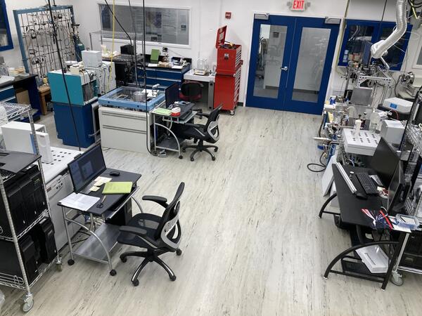
Geology, Geophysics, and Geochemistry Stable Isotope Laboratory
Geology, Geophysics, and Geochemistry Stable Isotope LaboratoryGeology, Geophysics, and Geochemistry Stable Isotope Laboratory. Photo by Craig Stricker (USGS).

Official websites use .gov
A .gov website belongs to an official government organization in the United States.
Secure .gov websites use HTTPS
A lock () or https:// means you’ve safely connected to the .gov website. Share sensitive information only on official, secure websites.
Here, you'll find images related to research going on at the Fort Collins Science Center. Our team of scientists are working on multiple areas of environmental interest, ranging from land conservation effectiveness to invasive reptiles.
Geology, Geophysics, and Geochemistry Stable Isotope Laboratory. Photo by Craig Stricker (USGS).
Geology, Geophysics, and Geochemistry Stable Isotope Laboratory. Photo by Craig Stricker (USGS).

Wild horses stand in sagebrush landscape in the Frisco Herd Management Area, Utah. Photo by E. Long.
Wild horses stand in sagebrush landscape in the Frisco Herd Management Area, Utah. Photo by E. Long.

Working with the National Park Service Northern Colorado Plateau Network we are analyzing data from over 20 sites along the Green and Yampa rivers in Utah and Colorado, integrating annual data from thousands of 1-m2 plots, including plant species occurrence, surface elevation and percentage of time under water.
Working with the National Park Service Northern Colorado Plateau Network we are analyzing data from over 20 sites along the Green and Yampa rivers in Utah and Colorado, integrating annual data from thousands of 1-m2 plots, including plant species occurrence, surface elevation and percentage of time under water.
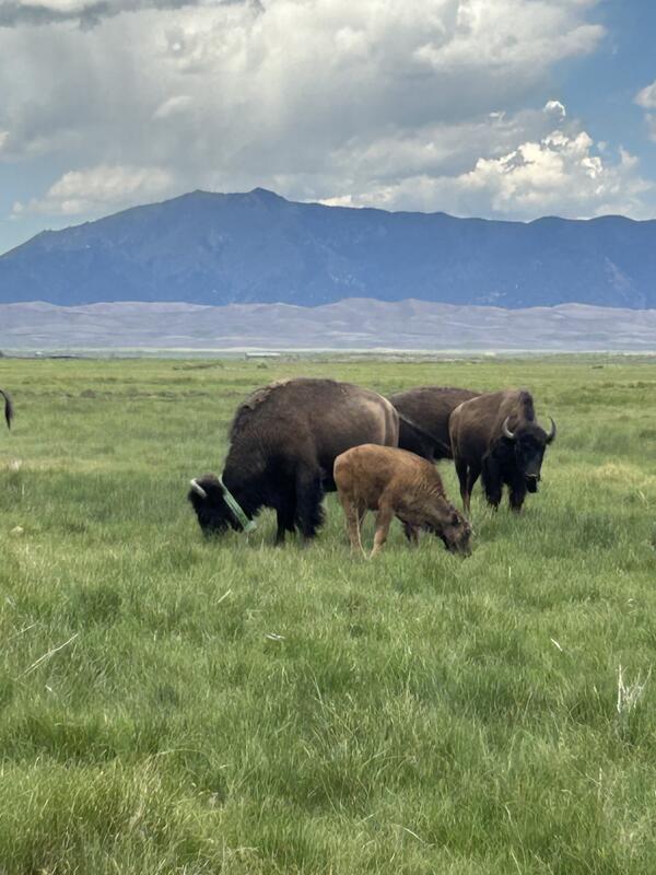
GPS-collared bison grazing in a field within Great Sand Dunes National Park.
GPS-collared bison grazing in a field within Great Sand Dunes National Park.
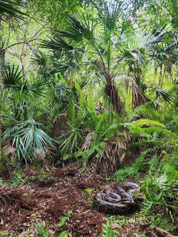
A large Burmese python in the Florida Everglades. Photo by Matthew Metcalf (USGS).
A large Burmese python in the Florida Everglades. Photo by Matthew Metcalf (USGS).

Wild horses of the Conger Herd Management Area, Utah. Photo by Sarah King (Colorado State University).
Wild horses of the Conger Herd Management Area, Utah. Photo by Sarah King (Colorado State University).
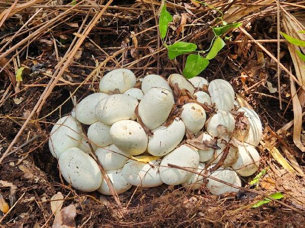
A nest of Burmese python eggs in the Florida Everglades. Photo by Matthew Metcalf (USGS).
A nest of Burmese python eggs in the Florida Everglades. Photo by Matthew Metcalf (USGS).

Wild horses in a sagebrush landscape in the Frisco Herd Management Area, Utah. Photo by L. Prevot.
Wild horses in a sagebrush landscape in the Frisco Herd Management Area, Utah. Photo by L. Prevot.

Cinnamon teal with a GPS tracking backpack that weighs 10 grams, making it much more successful in staying on longer than heavier tracking devices.
Cinnamon teal with a GPS tracking backpack that weighs 10 grams, making it much more successful in staying on longer than heavier tracking devices.
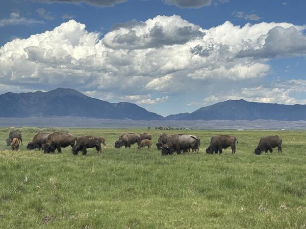
Bison graze in a field within the Great Sand Dunes National Park, Colorado.
Bison graze in a field within the Great Sand Dunes National Park, Colorado.
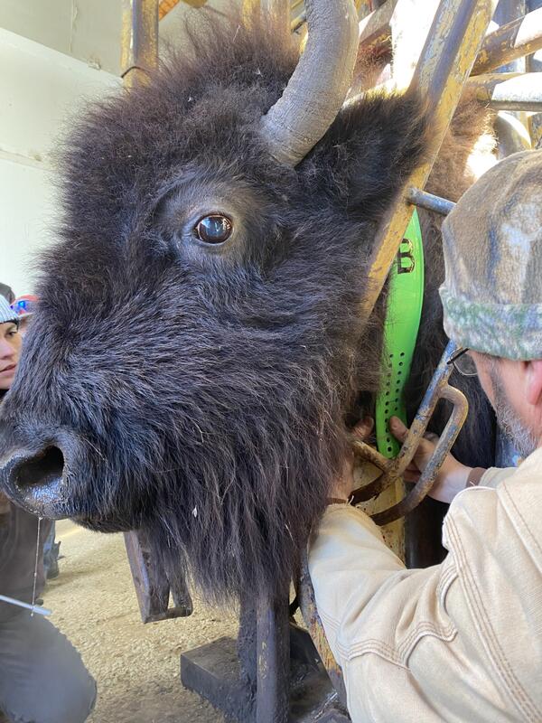
Researchers add a GPS-tracking collar to a bison, to aid in bison population monitoring and research on the foraging ecology of bison.
Researchers add a GPS-tracking collar to a bison, to aid in bison population monitoring and research on the foraging ecology of bison.
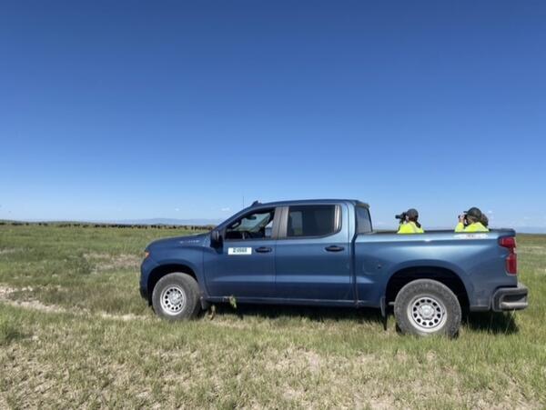
USGS wildlife biologists studying the grazing behavior of bison in Great Sand Dunes National Park.
USGS wildlife biologists studying the grazing behavior of bison in Great Sand Dunes National Park.
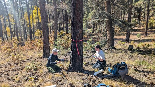
Andreas Wion and Melanie Wright core opposite sides of a ponderosa pine tree in a forest near Santa Fe, NM. This forest was thinned and treated with prescribed fire to reduce forest density and fuels, thereby reducing the risk of severe wildfire. Photo by Carolina May (USGS).
Andreas Wion and Melanie Wright core opposite sides of a ponderosa pine tree in a forest near Santa Fe, NM. This forest was thinned and treated with prescribed fire to reduce forest density and fuels, thereby reducing the risk of severe wildfire. Photo by Carolina May (USGS).

A field notebook entry from 3/2/10 from data collection and equipment maintenance for long term monitoring in the Loch Vale Watershed, Rocky Mountain National Park. Screenshot taken from FieldBook20100112_20100413 from https://doi.org/10.5066/P1CXWAVP.
Entry Text:
A field notebook entry from 3/2/10 from data collection and equipment maintenance for long term monitoring in the Loch Vale Watershed, Rocky Mountain National Park. Screenshot taken from FieldBook20100112_20100413 from https://doi.org/10.5066/P1CXWAVP.
Entry Text:

A field notebook entry from 3/25/97 from data collection and equipment maintenance for long term monitoring in the Loch Vale Watershed, Rocky Mountain National Park. Screenshot taken from FieldBook19960507_20060627_p2 from https://doi.org/10.5066/P1CXWAVP.
Entry text: 1st day of 1997 sampling
A field notebook entry from 3/25/97 from data collection and equipment maintenance for long term monitoring in the Loch Vale Watershed, Rocky Mountain National Park. Screenshot taken from FieldBook19960507_20060627_p2 from https://doi.org/10.5066/P1CXWAVP.
Entry text: 1st day of 1997 sampling

A map of the locations of all sample sites within Loch Vale and additional long-term sites in Rocky Mountain National Park is included with the field notebook files. From:
A map of the locations of all sample sites within Loch Vale and additional long-term sites in Rocky Mountain National Park is included with the field notebook files. From:

A field notebook entry from 8/29/19 from data collection and equipment maintenance for long term monitoring in the Loch Vale Watershed, Rocky Mountain National Park. Screenshot taken from FieldBook20190819_20201208_p1 from https://doi.org/10.5066/P1CXWAVP.
A field notebook entry from 8/29/19 from data collection and equipment maintenance for long term monitoring in the Loch Vale Watershed, Rocky Mountain National Park. Screenshot taken from FieldBook20190819_20201208_p1 from https://doi.org/10.5066/P1CXWAVP.

A field notebook entry from 12/14/87 from data collection and equipment maintenance for long term monitoring in the Loch Vale Watershed, Rocky Mountain National Park. Screenshot taken from FieldBook19871006_19891031_p1 from https://doi.org/10.5066/P1CXWAVP.
A field notebook entry from 12/14/87 from data collection and equipment maintenance for long term monitoring in the Loch Vale Watershed, Rocky Mountain National Park. Screenshot taken from FieldBook19871006_19891031_p1 from https://doi.org/10.5066/P1CXWAVP.

A sea of sagebrush in Seedskadee National Wildlife Refuge. Photo by Emma Dietrich (USGS).
A sea of sagebrush in Seedskadee National Wildlife Refuge. Photo by Emma Dietrich (USGS).

The spectacular Mojave Desert landscapes within Red Rock Canyon National Conservation area draw millions of visitors each year.
The spectacular Mojave Desert landscapes within Red Rock Canyon National Conservation area draw millions of visitors each year.

For most of the 1900s, sections of the Cotoni-Coast Dairies unit of the California Coast National Monument were mined for limestone and shale. Minerals were transported to the cement plant from the top of quarries through conveyer belts like this one.
For most of the 1900s, sections of the Cotoni-Coast Dairies unit of the California Coast National Monument were mined for limestone and shale. Minerals were transported to the cement plant from the top of quarries through conveyer belts like this one.