
The exterior of FIDO, a new instrument developed by the Monterey Bay Aquarium Research Institute (MBARI) and the USGS Rapid eDNA Assessment and Deployment Initiative and Network (READI-Net) project.
Multimedia
Search here for some of our available field imagery and videos. Can't find what you are looking for? Contact twojtowicz@usgs.gov to see what we have available.
Images
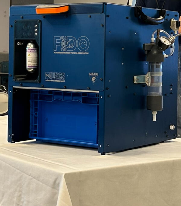
Exterior of FIDO: A new eDNA sampler
The exterior of FIDO, a new instrument developed by the Monterey Bay Aquarium Research Institute (MBARI) and the USGS Rapid eDNA Assessment and Deployment Initiative and Network (READI-Net) project.

Two anglers in western Montana
Two anglers enjoying the World class fishing that western Montana rivers has to offer.
Two anglers enjoying the World class fishing that western Montana rivers has to offer.

Angler in western Montana holding brown trout
Angler who was fishing in a western Montana river holding a brown trout they caught
Angler who was fishing in a western Montana river holding a brown trout they caught

Bison and elk feeding at the National Elk Refuge with map inset showing land holdings of core elk range around refuge
Bison and elk feeding at the National Elk Refuge with map inset showing land holdings of core elk range around refugeElk and bison being fed on the National Elk Refuge, Wyoming. Grand Teton and Grand Teton National Park are in the background. A map inset shows federal, state, and private land holdings of core winter elk range around the National Elk Refuge (labeled as the FWS unit). Map was generated by the USGS.

Winter elk range land holdings around National Elk Refuge
Winter elk range land holdings around National Elk RefugeMap showing federal, state, and private land holdings of core winter elk range around the National Elk Refuge (labeled as the FWS unit). Map was generated by the USGS.
Winter elk range land holdings around National Elk Refuge
Winter elk range land holdings around National Elk RefugeMap showing federal, state, and private land holdings of core winter elk range around the National Elk Refuge (labeled as the FWS unit). Map was generated by the USGS.

Winter elk range land holdings around National Elk Refuge-Cropped
Winter elk range land holdings around National Elk Refuge-CroppedMap showing federal, state, and private land holdings of core winter elk range around the National Elk Refuge (labeled as the FWS unit). Map was generated by the USGS.
Winter elk range land holdings around National Elk Refuge-Cropped
Winter elk range land holdings around National Elk Refuge-CroppedMap showing federal, state, and private land holdings of core winter elk range around the National Elk Refuge (labeled as the FWS unit). Map was generated by the USGS.
Videos

Going-to-the-Sun Road Avalanche Forecasting Program
Going-to-the-Sun Road Avalanche Forecasting ProgramGoing to the Sun Road: one of the most scenic drives in the United States. It winds through the high peaks of northern Montana, past glaciers and mountains, waterfalls and grizzly bears.
Going-to-the-Sun Road Avalanche Forecasting Program
Going-to-the-Sun Road Avalanche Forecasting ProgramGoing to the Sun Road: one of the most scenic drives in the United States. It winds through the high peaks of northern Montana, past glaciers and mountains, waterfalls and grizzly bears.
Going-to-the-Sun Road Avalanche Forecasting Program (AD)
Going-to-the-Sun Road Avalanche Forecasting Program (AD)Going to the Sun Road: one of the most scenic drives in the United States. It winds through the high peaks of northern Montana, past glaciers and mountains, waterfalls and grizzly bears.
Going-to-the-Sun Road Avalanche Forecasting Program (AD)
Going-to-the-Sun Road Avalanche Forecasting Program (AD)Going to the Sun Road: one of the most scenic drives in the United States. It winds through the high peaks of northern Montana, past glaciers and mountains, waterfalls and grizzly bears.

Uploading Stationary/Mobile Acoustic Surveys to the NABat Partner Portal
Uploading Stationary/Mobile Acoustic Surveys to the NABat Partner PortalNABat Training Webinar on how to upload acoustic survey data to the NABat Partner Portal. Hosted by Dane Smith (USGS).
Uploading Stationary/Mobile Acoustic Surveys to the NABat Partner Portal
Uploading Stationary/Mobile Acoustic Surveys to the NABat Partner PortalNABat Training Webinar on how to upload acoustic survey data to the NABat Partner Portal. Hosted by Dane Smith (USGS).
")
Managing Large Datasets Workshop (Day 1)
NABat Virtual Workshop: Managing Large Datasets
Day 1 covered data storage and management, quality assurance/control of incoming data, batch attribution and data curation, and batch processing of auto-classifiers.
Hosted by the NABat Stationary Acoustic Working Group.
NABat Virtual Workshop: Managing Large Datasets
Day 1 covered data storage and management, quality assurance/control of incoming data, batch attribution and data curation, and batch processing of auto-classifiers.
Hosted by the NABat Stationary Acoustic Working Group.
")
Florida Bonneted Bat Data Submission Workshop (Part 2 - Creating an NABat Project and Species List)
Florida Bonneted Bat Data Submission Workshop (Part 2 - Creating an NABat Project and Species List)Recording of the Florida Bonneted Bat Data Submission Workshop: Part 2 - Creating an NABat Project and Species List
Spreaker: Roxanne Pourshoushtari (USGS)
Presentation contributors and moderators: Laura D’Acunto (USGS) and Sandra Sneckenberger (FWS)

Planning, Partner Portal Prep, & Protocols for Mobile Acoustic Surveys
Planning, Partner Portal Prep, & Protocols for Mobile Acoustic SurveysTraining webinar for Mobile Acoustic Surveying hosted by Sarah Gaulke (USGS). The webinar details preparing for and implementing Mobile Acoustic Surveys for bat monitoring, including how to use the NABat Partner Portal to plan a survey route