Bebbia juncea, a native plant growing in western Grand Canyon
Bebbia juncea, a native plant growing in western Grand CanyonBebbia juncea, a native plant growing in western Grand Canyon. Photo by Emily Palmquist, USGS.

Official websites use .gov
A .gov website belongs to an official government organization in the United States.
Secure .gov websites use HTTPS
A lock () or https:// means you’ve safely connected to the .gov website. Share sensitive information only on official, secure websites.
Below are images associated with SBSC's science and staff. Images appear according to the year they were taken. To search, type a keyword or select a year from the dropdown menu. Or, click through the pages using the arrows at the bottom of the page.
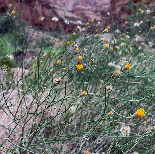
Bebbia juncea, a native plant growing in western Grand Canyon. Photo by Emily Palmquist, USGS.
Bebbia juncea, a native plant growing in western Grand Canyon. Photo by Emily Palmquist, USGS.

USGS Southwest Biological Science Center (SBSC) ecologist and botanist Laura Shriver (center) and colleagues at the Society for Range Management Conference. Laura gave a talk titled, "RestoreNet: a field trial network to improve restoration outcomes across environmental gradients".
USGS Southwest Biological Science Center (SBSC) ecologist and botanist Laura Shriver (center) and colleagues at the Society for Range Management Conference. Laura gave a talk titled, "RestoreNet: a field trial network to improve restoration outcomes across environmental gradients".

RestoreNet is a networked ecological restoration experiment spanning drylands of the American Southwest. It is engaging diverse partners to develop methods for successful revegetation projects that mitigate the effects of drought, invasion by non-native species, and land use practices.
RestoreNet is a networked ecological restoration experiment spanning drylands of the American Southwest. It is engaging diverse partners to develop methods for successful revegetation projects that mitigate the effects of drought, invasion by non-native species, and land use practices.

Illustration of 3 native fish in the Colorado River, Grand Canyon: humpback chub (Gila cypha, upper left), flannelmouth sucker (Catostomus latipinnis, middle), and bluehead sucker (Catostomus discobolus, lower right). Illustration by Lindsay Hansen, USGS.
Illustration of 3 native fish in the Colorado River, Grand Canyon: humpback chub (Gila cypha, upper left), flannelmouth sucker (Catostomus latipinnis, middle), and bluehead sucker (Catostomus discobolus, lower right). Illustration by Lindsay Hansen, USGS.
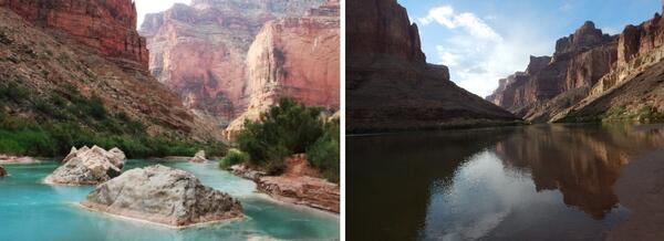
The Little Colorado River (on left) and Colorado River (on right), near the Little Colorado River confluence, looking upstream.
The Little Colorado River (on left) and Colorado River (on right), near the Little Colorado River confluence, looking upstream.

Scenic view of the red rock mesas surrounding Canyonlands Research Center (The Nature Conservancy) in southern Utah.
Scenic view of the red rock mesas surrounding Canyonlands Research Center (The Nature Conservancy) in southern Utah.

Cattle inside a grazing enclosure at Canyonlands Research Center (The Nature Conservancy) in southern Utah.
Cattle inside a grazing enclosure at Canyonlands Research Center (The Nature Conservancy) in southern Utah.
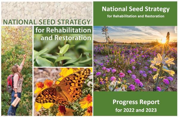
Covers of the Plant Conservation Alliance National Seed Strategy Progress Report for 2022 and 2023 (left) and the National Seed Strategy for Rehabilitation and Restoration (right).
Covers of the Plant Conservation Alliance National Seed Strategy Progress Report for 2022 and 2023 (left) and the National Seed Strategy for Rehabilitation and Restoration (right).
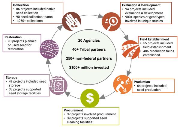
Accomplishments in Native Seed Development.
Accomplishments in Native Seed Development.

A RestoreNet Field Trial Network restoration experiment site in the Sonoran Desert, Arizona, in spring 2024. Photo by Laura Shriver (USGS).
A RestoreNet Field Trial Network restoration experiment site in the Sonoran Desert, Arizona, in spring 2024. Photo by Laura Shriver (USGS).

Southwest Biological Science Center (SBSC) research garden hoop houses at the USGS Flagstaff campus. The hoop houses block natural precipitation, so the only water received is from treatments.
Southwest Biological Science Center (SBSC) research garden hoop houses at the USGS Flagstaff campus. The hoop houses block natural precipitation, so the only water received is from treatments.

Native Phragmites (Phragmites australis spp. americanus), or common reed, along the Colorado River near Tanner Rapids (part of the Tanner Trail), in Grand Canyon. Photo by Emily Palmquist, USGS Southwest Biological Science Center.
Native Phragmites (Phragmites australis spp. americanus), or common reed, along the Colorado River near Tanner Rapids (part of the Tanner Trail), in Grand Canyon. Photo by Emily Palmquist, USGS Southwest Biological Science Center.

Desert marigold (Baileya multiradiata) blooming in a monitoring quadrat at a RestoreNet site in Northern Arizona. Photo by Laura Shriver (USGS).
Desert marigold (Baileya multiradiata) blooming in a monitoring quadrat at a RestoreNet site in Northern Arizona. Photo by Laura Shriver (USGS).
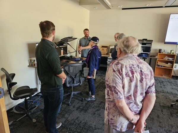
USGS cartographer Ben Wheeler engages with the public in the Photogrammetry Lab in the Astrogeology building at the 2024 USGS Flagstaff Open House. Photo by Lori Pigue, USGS.
USGS cartographer Ben Wheeler engages with the public in the Photogrammetry Lab in the Astrogeology building at the 2024 USGS Flagstaff Open House. Photo by Lori Pigue, USGS.
USGS cartographer Ben Wheeler engages with the public in the Photogrammetry Lab in the Astrogeology building at the 2024 USGS Flagstaff Open House. Photo by Lori Pigue, USGS.
USGS cartographer Ben Wheeler engages with the public in the Photogrammetry Lab in the Astrogeology building at the 2024 USGS Flagstaff Open House. Photo by Lori Pigue, USGS.
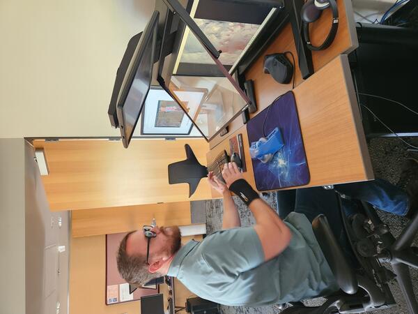
USGS cartographer Ben Wheeler works in the Astrogeology Photogrammetry Lab at the USGS Flagstaff science campus.
USGS cartographer Ben Wheeler works in the Astrogeology Photogrammetry Lab at the USGS Flagstaff science campus.
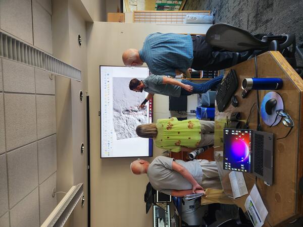
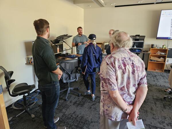
USGS cartographer Ben Wheeler discusses planetary geology with the public in the Photogrammetry Lab at the Astrogeology building on the Flagstaff USGS science campus, during an Open House.
USGS cartographer Ben Wheeler discusses planetary geology with the public in the Photogrammetry Lab at the Astrogeology building on the Flagstaff USGS science campus, during an Open House.

Illustration of Colorado River Basin, showing upper and lower basins with a red text box around the Colorado River in Grand Canyon. Reduced-size map of the Colorado River Basin from the USGS ASIST Initiative, Sept. 3, 2024.
Illustration of Colorado River Basin, showing upper and lower basins with a red text box around the Colorado River in Grand Canyon. Reduced-size map of the Colorado River Basin from the USGS ASIST Initiative, Sept. 3, 2024.

Zach Harrison collects a water quality sample at Willow Spring, AZ. Photo courtesy of Kat Cooney, AZ Water Science Center.
Zach Harrison collects a water quality sample at Willow Spring, AZ. Photo courtesy of Kat Cooney, AZ Water Science Center.
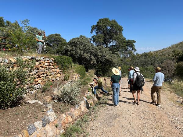
Albert Klein (University of Arizona) shows the pollinator garden designed and installed by University of Arizona students at the Santa Rita Experimental Range. Photo by Laura Shriver (USGS).
Albert Klein (University of Arizona) shows the pollinator garden designed and installed by University of Arizona students at the Santa Rita Experimental Range. Photo by Laura Shriver (USGS).

Kat Cooney of the Arizona Water Science Center (AZWSC) runs an alkalinity titration in a mobile lab. Photo courtesy of Kat Cooney, USGS.
Kat Cooney of the Arizona Water Science Center (AZWSC) runs an alkalinity titration in a mobile lab. Photo courtesy of Kat Cooney, USGS.