
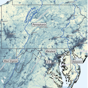
Groundwater and Streamflow Information
Surface-water Monitoring, Groundwater monitoring, and Flood Hazards
Surface-water Monitoring, Groundwater monitoring, and Flood Hazards
Water Use and Availability
Surface-water Modeling, Groundwater-flow Modeling, Hydrogeologic Characterization, Water Use, Flood Science, Climate Change
Surface-water Modeling, Groundwater-flow Modeling, Hydrogeologic Characterization, Water Use, Flood Science, Climate Change
Water Quality
Surface-water-quality Monitoring, Groundwater-quality Monitoring, Water-quality Modeling, Wetlands, Ecosystem Health
Surface-water-quality Monitoring, Groundwater-quality Monitoring, Water-quality Modeling, Wetlands, Ecosystem Health
Coastal Science
Beach and Barrier Dynamics, Flood Hazards, Nearshore Environmental Health, Tide and Wave Hydrodynamics, Wetlands, Climate and Land-Use Change
Beach and Barrier Dynamics, Flood Hazards, Nearshore Environmental Health, Tide and Wave Hydrodynamics, Wetlands, Climate and Land-Use Change
Ecosystem Health
Aquatic Community Health, Biogeochemical and Hydrologic Assessment, Climate Change, Ecological Assessment of Human and Natural Impacts
Aquatic Community Health, Biogeochemical and Hydrologic Assessment, Climate Change, Ecological Assessment of Human and Natural Impacts
New York Water Science Center
The New York Water Science Center will provide the hydrologic observations, research, and modeling needed for full integration of hydrogeologic, physiochemical, biological, and landscape processes across the freshwater to marine continuum.


NY WSC Quick Links
NY WSC Quick Links
Explore some of our most popular science topics, data, and tools
News
USGS Satellites and Test Tubes Meet to Ensure Safe Drinking Water
USGS Satellites and Test Tubes Meet to Ensure Safe Drinking Water
Advanced Quantitative Precipitation Information System Enhances Flood Prediction in San Francisco Bay Area
Advanced Quantitative Precipitation Information System Enhances Flood Prediction in San Francisco Bay Area
Native American Research Assistantship Student Learns USGS Water Science
Native American Research Assistantship Student Learns USGS Water Science
Publications
Investigation of fish communities in natural channel sections of the Mohawk River, New York Investigation of fish communities in natural channel sections of the Mohawk River, New York
Little is known about the natural resources in the natural channel sections of the Mohawk River between Rome and Frankfort, New York, where the river channel runs separately from and parallel to the Erie Canal. This river section runs through multiple locations that are listed as active remediation sites under New York’s Inactive Hazardous Waste Disposal Site Program and has negligible...
Evaluating drivers of environmental change in a lake sediment core: Insights from spectroscopic metrics of water-extractable organic matter and stable carbon isotopes Evaluating drivers of environmental change in a lake sediment core: Insights from spectroscopic metrics of water-extractable organic matter and stable carbon isotopes
Freshwater lakes play a critical role in the global carbon cycle by storing and transforming organic matter (OM) from both terrestrial and aquatic sources. Small lakes in northern temperate regions, despite their limited surface area, disproportionately influence regional carbon budgets. Buried sediments integrate OM inputs over time and archive ecosystem responses to natural and...
A targeted approach for mapping groundwater discharge to surface water and fish thermal refuge in four Lake Ontario tributaries A targeted approach for mapping groundwater discharge to surface water and fish thermal refuge in four Lake Ontario tributaries
The duration, magnitude, and frequency of heatwaves are predicted to increase in the coming decades, a combination that can reduce the survival of many fish species. Across the world, there is broad interest in identifying thermal refuge for heat-intolerant fish species and exploring opportunities to enhance or protect these areas. Because deeper groundwater maintains a relatively...
Science
Evaluating the Risks of Tire-Derived Compounds to Fish in the Chesapeake Bay Watershed
Tires contain a chemical known as 6PPD which prevents them from quickly breaking down. Microscopic tire particles, generated mainly from the friction of tires on roads, release 6PPD-quinone (6PPDQ) when they come into contact with oxygen. During precipitation events, 6PPDQ can be washed off roads, harming fish in nearby waterways. In response to requests from fishery managers, the USGS is studying...
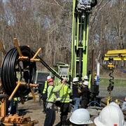
Interactive Products to Assist with Geothermal Drilling
Geothermal energy is a clean and renewable source of heat derived from the Earth's natural thermal resources. Geothermal borefields are utilized to extract this thermal energy, providing heating for buildings in the winter and cooling in the summer. In New York, the adoption of geothermal energy at both residential and community scales is on the rise and is expected to see significant growth in...
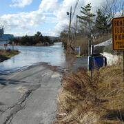
Regional Assessment of Compound Flood Hazard from the Combined Effects of Coastal, Stormwater and Groundwater Emergence Flooding
Compound flooding is flooding that results from a co-occurrence of multiple flood drivers. In this project we consider precipitation (pluvial flooding, overland flow of stormwater), coastal storm surge and tidal flooding (coastal flooding), and flooding that occurs as a shallow water table intersects the land surface or critical infrastructure (groundwater emergence flooding). These flooding...