
A lahar is a volcanic mudflow. Learn if you are if you are in a lahar hazard zone and how to evacuate to high ground. If you are in a lahar hazard zone and get a lahar alert - go now! Every second matters.
Images
Volcano Hazard Program images.
Filter Total Items: 6274
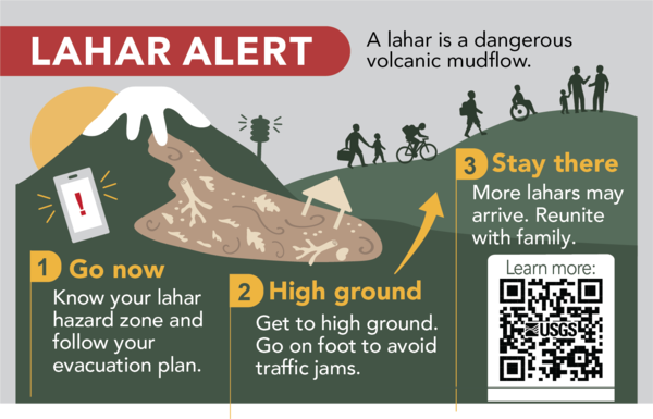
Lahar Safety Infographic
A lahar is a volcanic mudflow. Learn if you are if you are in a lahar hazard zone and how to evacuate to high ground. If you are in a lahar hazard zone and get a lahar alert - go now! Every second matters.

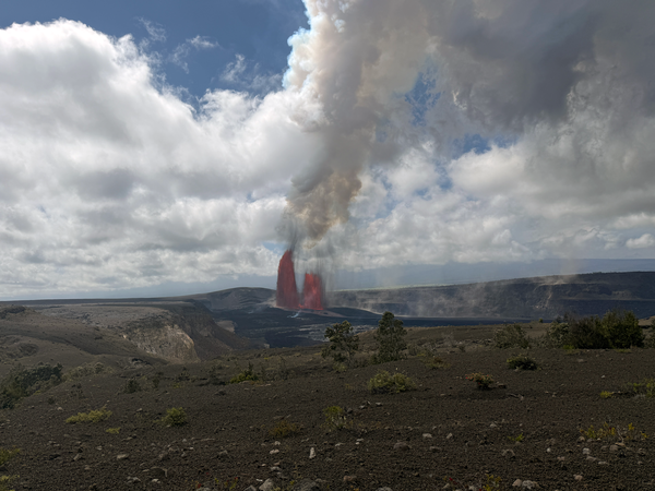
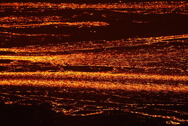
Episode 43 of the ongoing Halema‘uma‘u eruption at Kīlauea summit
Episode 43 of the ongoing Halema‘uma‘u eruption at Kīlauea summitEpisode 43 of the ongoing Halema‘uma‘u eruption at Kīlauea summit ended at 6:21 p.m. HST on March 10. About 15 minutes after the end of the episode, USGS scientists serviced a webcam near Keanakāko‘i on the southeast caldera rim. Active lava flows continued to slowly advance along the crater floor, and stand out here in the low lighting.
Episode 43 of the ongoing Kīlauea summit eruption
On March 10, 2026, lava fountains erupted from two main vents within Halema‘uma‘u crater. During the ongoing episodic Kīlauea summit eruption, which began on December 23, 2024. There have been 43 episodes so far. USGS photo taken by L. DeSmither from Keanakāko‘i.
On March 10, 2026, lava fountains erupted from two main vents within Halema‘uma‘u crater. During the ongoing episodic Kīlauea summit eruption, which began on December 23, 2024. There have been 43 episodes so far. USGS photo taken by L. DeSmither from Keanakāko‘i.
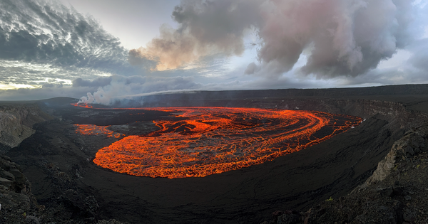
Episode 43 of the Kīlauea summit eruption
Episode 43, which began at 9:17 a.m. HST on March 10, erupted for just over 9 hours before pausing again at 6:21 p.m. This panoramic view of episode 43 lava flows on Halema‘uma‘u crater floor was taken a few minutes after the fountaining stopped. USGS photo taken by L. DeSmither near Keanakāko‘i on the southeast rim of the caldera.
Episode 43, which began at 9:17 a.m. HST on March 10, erupted for just over 9 hours before pausing again at 6:21 p.m. This panoramic view of episode 43 lava flows on Halema‘uma‘u crater floor was taken a few minutes after the fountaining stopped. USGS photo taken by L. DeSmither near Keanakāko‘i on the southeast rim of the caldera.

Episode 43 of the Kīlauea summit eruption
A USGS scientist performs maintenance on an eruption monitoring camera during episode 43 of the ongoing Kīlauea summit eruption. Work within this area, which is closed to the public, is done with permission from Hawai‘i Volcanoes National Park. USGS photo taken by L. DeSmither on March 10, 2026.
A USGS scientist performs maintenance on an eruption monitoring camera during episode 43 of the ongoing Kīlauea summit eruption. Work within this area, which is closed to the public, is done with permission from Hawai‘i Volcanoes National Park. USGS photo taken by L. DeSmither on March 10, 2026.

Episode 43 of the Kīlauea summit eruption
Episode 43 of the ongoing Kīlauea summit eruption occurred on March 10. Lava fountains from the north and south vents on the western side of Halema‘uma‘u crater floor produced a large eruption plume of volcanic gases and rock fragments (tephra).
Episode 43 of the ongoing Kīlauea summit eruption occurred on March 10. Lava fountains from the north and south vents on the western side of Halema‘uma‘u crater floor produced a large eruption plume of volcanic gases and rock fragments (tephra).
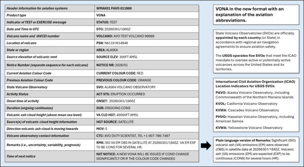
Example Volcano Observatory Notice for Aviation (VONA) in the 2026 ICAO‑aligned format.
Example Volcano Observatory Notice for Aviation (VONA) in the 2026 ICAO‑aligned format.Released in March 2026, the updated Volcano Observatory Notice for Aviation (VONA) format uses standardized aviation terminology to describe volcanic activity and potential ash hazards for pilots and aviation authorities. The updated VONA follows recommended practices from the International Civil Aviation Organization.
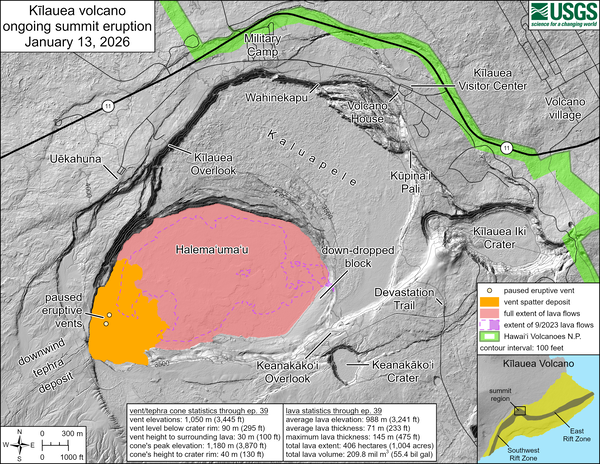
January 13, 2026—Kīlauea summit eruption reference map
January 13, 2026—Kīlauea summit eruption reference mapThis reference map depicts the Kīlauea summit eruption within Halema‘uma‘u crater that began on December 23, 2024. The data for this map were collected during a Hawaiian Volcano Observatory helicopter overflight on January 2, 2026; as such, the provided statistics are reflective of the first thirty-nine episodes of the eruption through December 24, 2025.
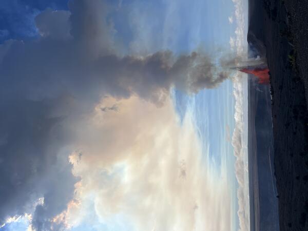
January 12, 2026 — Kīlauea episode 40 from Uēkahuna
January 12, 2026 — Kīlauea episode 40 from UēkahunaOn January 12, 2026, Kīlauea had its 40th fountaining episode of the ongoing eruption within Halema‘uma‘u. This view was taken at 10:50 a.m. H.S.T. from the publicly accessible viewing area at Uēkahuna within Hawaiʻi Volcanoes National Park, showing north vent fountaining. USGS photo by N. Deligne.
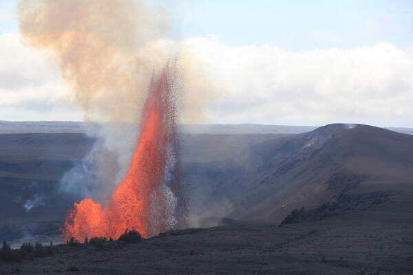
January 12, 2026 — Kīlauea episode 40 fountains from Uēkahuna overlook
January 12, 2026 — Kīlauea episode 40 fountains from Uēkahuna overlookUSGS Hawaiian Volcano Observatory geologists observe episode 40 fountains from the Uēkahuna overlook within Hawai‘i Volcanoes National Park. This episode had multiple days of precursory overflows from both the north and south vents, leading to fountains primarily from the north vent starting on January 12 and reaching up to 800 feet (250 meters).
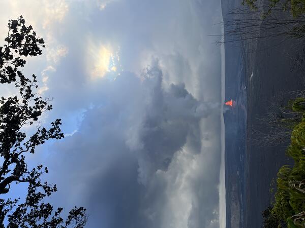
January 12, 2026 — Kīlauea episode 40 from Kūpinaʻi Pali
January 12, 2026 — Kīlauea episode 40 from Kūpinaʻi PaliOn January 12, 2026, Kīlauea had its 40th fountaining episode of the ongoing eruption within Halema‘uma‘u. This photo was taken at 4:37 p.m. HST from the publicly accessible viewing area at Kūpinaʻi Pali (Waldron's Ledge) within Hawaiʻi Volcanoes National Park, showing north vent fountaining. The episode ended about an hour and a half after this photo was taken.
November 25, 2025—Kīlauea summit eruption episode 37 lava flow
November 25, 2025—Kīlauea summit eruption episode 37 lava flowThe telephoto shows lava flowing east across the floor of Halemaʻumaʻu crater, fed by the lava fountains in the west part of the crater. Preliminary estimates suggest that approximately 6 million cubic meters (7.8 million cubic yards) of lava were erupted during episode 37, based on ground deformation data. USGS photo by M. Patrick.
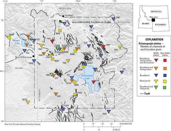
Yellowstone seismic network
Map of seismic stations in the Yellowstone region, with numbers of channels indicated by number and sensor type by color. Inverted triangles indicate stations operated by University of Utah Seismograph Stations (UUSS), and squares indicate stations operated by other agencies.
Map of seismic stations in the Yellowstone region, with numbers of channels indicated by number and sensor type by color. Inverted triangles indicate stations operated by University of Utah Seismograph Stations (UUSS), and squares indicate stations operated by other agencies.
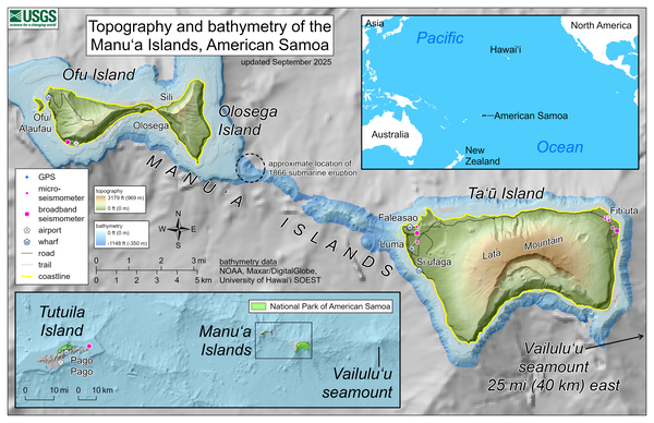
September 2025—Topography and bathymetry of the Manuʻa Islands, American Samoa
September 2025—Topography and bathymetry of the Manuʻa Islands, American SamoaThis reference map depicts the volcanoes of the Manuʻa Islands, American Samoa, which are monitored by the USGS Hawaiian Volcano Observatory.
September 2025—Topography and bathymetry of the Manuʻa Islands, American Samoa
September 2025—Topography and bathymetry of the Manuʻa Islands, American SamoaThis reference map depicts the volcanoes of the Manuʻa Islands, American Samoa, which are monitored by the USGS Hawaiian Volcano Observatory.
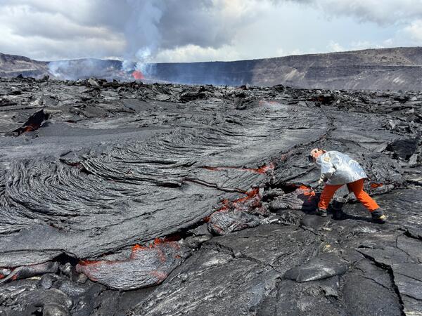
Episode 30 lava fountaining at Kīlauea summit
A USGS geologist collects a molten sample of the episode 30 lava flows, quenching the sample in a bucket of water. The chemistry of these lava samples is analyzed to better understand the source and storage of magma driving Hawaiian eruptions. USGS photo by M. Patrick taken on August 6, 2025.
A USGS geologist collects a molten sample of the episode 30 lava flows, quenching the sample in a bucket of water. The chemistry of these lava samples is analyzed to better understand the source and storage of magma driving Hawaiian eruptions. USGS photo by M. Patrick taken on August 6, 2025.
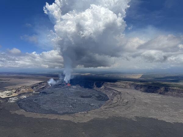
Episode 30 lava fountaining at Kīlauea summit
A helicopter overflight on the morning of August 6, during episode 30 of the ongoing Halema‘uma‘u eruption, provided aerial views of the lava fountaining and numerous channelized lava flows covering the crater floor. USGS photo by M. Patrick.
A helicopter overflight on the morning of August 6, during episode 30 of the ongoing Halema‘uma‘u eruption, provided aerial views of the lava fountaining and numerous channelized lava flows covering the crater floor. USGS photo by M. Patrick.
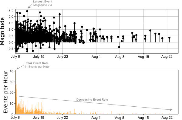
Earthquake magnitudes and numbers over time during July 8 - August 25, 2025, Mount Rainier earthquake swarm
Earthquake magnitudes and numbers over time during July 8 - August 25, 2025, Mount Rainier earthquake swarmPlots of earthquake magnitudes (top) and numbers (bottom) over the course of the July 8 - August 25, 2025 seismic swarm at Mount Rainier, Washington. The swarm was greatest in terms of numbers of events on the morning of July 8. After that time, earthquake rates slowly decreased over the course of the following days.

Aerial overview of Kīlauea summit tephra deposit
On Friday, March 14, Hawaiian Volcano Observatory geologists on a morning helicopter overflight captured aerial photography to map tephra deposits downwind (southwest) of vents from the Kīlauea summit eruption that began December 23, 2024.
On Friday, March 14, Hawaiian Volcano Observatory geologists on a morning helicopter overflight captured aerial photography to map tephra deposits downwind (southwest) of vents from the Kīlauea summit eruption that began December 23, 2024.

March 14, 2025 —Aerial view of Halema‘uma‘u crater
March 14, 2025 —Aerial view of Halema‘uma‘u craterA closer view of Halema‘uma‘u and the downdropped block, within the deepest portion of Kīlauea's summit caldera. Lava flows have crept eastward (towards bottom left in photo) as the crater floor rises with recent infilling. USGS photo taken on March 14, 2025, by M. Patrick.

March 14, 2025 — Kīlauea summit eruption overflight with Mauna Loa in the background
March 14, 2025 — Kīlauea summit eruption overflight with Mauna Loa in the backgroundA low-angle aerial view of the vents where episodic fountaining has been occurring since the start of the ongoing Kīlauea summit eruption on December 23, 2024. A white plume of volcanic gas rises from the north vent (center right) and south vent (center left) cones in the southwest corner of Halema‘uma‘u crater, as viewed during a monitoring overflight.

Low-level aerial view of Kīlauea summit tephra deposit
Low-level aerial view of Kīlauea summit tephra depositThis low-level aerial view of the tephra deposit from Kīlauea's ongoing summit eruption was captured during a Hawaiian Volcano Observatory helicopter overflight on Friday, March 14.
Low-level aerial view of Kīlauea summit tephra deposit
Low-level aerial view of Kīlauea summit tephra depositThis low-level aerial view of the tephra deposit from Kīlauea's ongoing summit eruption was captured during a Hawaiian Volcano Observatory helicopter overflight on Friday, March 14.