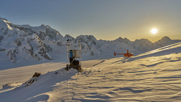
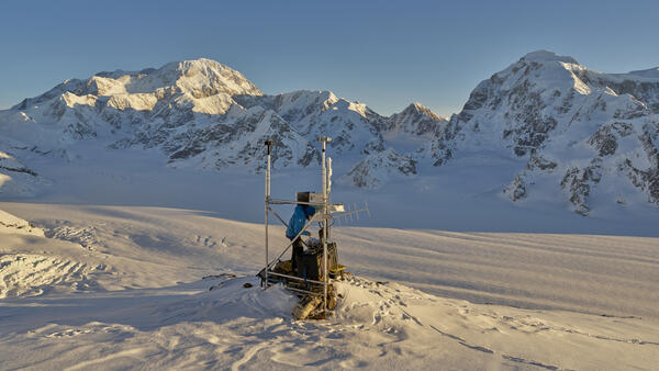
Remote weather stations, like this one at Wolverine Glacier, collect data near each glacier so scientists can understand regional climate influence on the glaciers.
Louis Sass, III
Glacier mass balance; physical processes of glacier mass balance; feedback mechanisms on glacier mass balance; glacier influences on streamflow
I came to Alaska in 1999 to climb in the Alaska Range, and returned to work as an outdoor educator and mountain guide. At the time that was not part of a grand plan to intimately familiarize myself with glacier behavior, but I found myself increasingly interested in the physical processes of glacier change. Now I am the project lead for the Alaska portion of the Benchmark Glacier Project, a long-term project that quantifies seasonal mass changes on five glaciers in the US, three of which are in Alaska. My research focuses on accurately quantifying glacier change, understanding the physical processes that contribute to that change, and identifying feedback mechanisms that influence future changes. I work to understand how glaciers (and glacier change) influence surrounding ecosystems, both directly in terms of downstream runoff to rivers and oceans, and indirectly in terms of the overall ecosystem and landscape evolution. I am also interested in trying to make glacier science and glacier data more digestible and more approachable for land managers, decision makers, and the public.
Professional Experience
2012 - Present Physical Scientist, USGS Alaska Science Center
2009 - 2011 Instructor, Alaska Pacific University, Glaciology and Glacier Travel field course
2009 - 2012 Student Trainee, USGS Alaska Science Center
Education and Certifications
M.S. 2011 Alaska Pacific University, Anchorage, AK Environmental Science
B.A. 2000 The Colorado College, Colorado Springs, CO Geology
Affiliations and Memberships*
International Glaciological Society
American Geophysical Union
Honors and Awards
NASA Earth and space science fellowship, 2009-2011
Science and Products
Glaciers and Climate Project
Gulkana Glacier
Lemon Creek Glacier
Wolverine Glacier
Assessing the Vulnerability of Alaska’s Glaciers in a Changing Climate
USGS Benchmark Glacier Project
Wolverine Glacier Ecosystem Studies
Annual End-of-Summer Snow Cover on Glaciers in Alaska and Northwest Canada
Firn Density and Stratigraphy Observations from USGS Benchmark Glaciers
USGS Benchmark Glacier Mass Balance and Project Data
Point Raw Glaciological Data: Ablation Stake, Snow Pit, and Probed Snow Depth Data on USGS Benchmark Glaciers
Geodetic Data for USGS Benchmark Glaciers: Orthophotos, Digital Elevation Models, Glacier Boundaries and Surveyed Positions
Glacier-Wide Mass Balance and Compiled Data Inputs
Raw Ground Penetrating Radar Data on North American Glaciers
High Altitude Weather Station Data at USGS Benchmark Glaciers
Point Measurements of Surface Mass Balance, Eklutna Glacier, Alaska, 2008-2015
Raw Ground Penetrating Radar Data, Valdez Glacier, Alaska; 2013
Raw Ground Penetrating Radar Data,Taku Glacier, Alaska; 2013
Raw Ground Penetrating Radar Data, Scott Glacier, Alaska; 2013
Remote weather stations, like this one at Wolverine Glacier, collect data near each glacier so scientists can understand regional climate influence on the glaciers.
Scientist uses radio-echo-sounding to study firn compaction on Wolverine Glacier, Alaska. Radio-echo sounding (RES) is a technique used by glaciologists to measure the internal structure, ice thickness and sub-ice morphology of glaciers. This tool is equivalent to X-rays for the medical profession and the physicists.
The Wolverine Glacier weather station was installed in 1968, and at 3250 ft is the highest elevation long-term weather record on the Kenai Peninsula. On October 19, 2020, USGS scientists upgraded the power system to a Lithium battery bank and installed a radar-based precipitation sensor (Lufft WS-100) to compare with the weighing based precipitation gage.
The Wolverine Glacier weather station was installed in 1968, and at 3250 ft is the highest elevation long-term weather record on the Kenai Peninsula. In Ocotober 2020, USGS scientists upgraded the power system to a Lithium battery bank and installed a radar-based precipitation sensor (Lufft WS-100) to compare with the weighing based precipitation gage. The
The Wolverine Glacier weather station was installed in 1968, and at 3250 ft is the highest elevation long-term weather record on the Kenai Peninsula. Close up of the new radar precipitation sensor on the top of the pole. The crazy looking thing in the middle of the picture is an aspirated temperature sensor.
The Wolverine Glacier weather station was installed in 1968, and at 3250 ft is the highest elevation long-term weather record on the Kenai Peninsula.
Ablation stakes on Gulkana Glacier, Alaska. Late summer fieldwork on Gulkana Glacier reveals ablation stakes emerging from the ice. Measurements of the change in the height of the snow and ice at these stakes is one aspect of determining glacier mass balance.
A scientist checks data collection on multiple sensors at the Gulkana Glacier weather station where snow blankets the glacier surface.
USGS scientist, Chris McNeil, measures and weighs an ice core extracted from Wolverine Glacier to determine the density of the firn layer.
A scientist prepares to extract a snow core from one of the Benchmark Glaciers. Cores are used to determine the density of the snow and ice on the surface of the glacier in order to determine the mass balance.
Researchers use ground penetrating radar to determine the depth of the snow on Wolverine Glacier. Wolverine Glacier is in the Kenai Mountains on the coast of south-central Alaska. In 1966 scientists with the USGS began making direct measurements of surface mass balance at Wolverine Glacier, one of the "benchmark glaciers" in Alaska.
A researcher locates an ablation stake near a crevasse on Wolverine Glacier. These collapsible poles are used to measure snow and ice melt on the glacier surface.
USGS scientist Louis Sass examines a full firn core taken on Wolverine Glacier, making observations of any notable dust or dirt layers in the snow and firn stratigraphy.
USGS scientist, Chris McNeil, collects data at an ablation stake on Wolverine Glacier near the end of the glacial melt season.
Heavily crevassed glacial ice flows across scoured rock in late summer at Gulkana Glacier, AK.
Gulkana Glacier is located along the south flank of the eastern Alaska Range.
Heavily crevassed terminus of Gulkana Glacier, AK, near the end of the 2016 ablation (melt) season.
A scientist dumps DNA tracer into a moulin on Wolverine Glacier to assess water flow through the glacier as part of research aimed at understanding glacier processes.
Scientist with ablation stake on Wolverine Glacier in Alaska. Scientist probes to determine snow depth near another ablation stake.
Measuring a snow core. The layers that make up snow cores are measured to determine the density of the snow and ice.
South Cascade Glacier, northwestern Washington State. South Cascade Glacier located in a north-northwest facing valley near the crest of the Cascade Range in northwest Washington state. In 1959 scientists with the USGS began collecting mass balance data on South Cascade Glacier, now one of five "benchmark glaciers" in the US.
Observing glacier elevation changes from spaceborne optical and radar sensors – an inter-comparison experiment using ASTER and TanDEM-X data
How to handle glacier area change in geodetic mass balance
Uncertainty of ICESat-2 ATL06- and ATL08-derived snow depths for glacierized and vegetated mountain regions
Beyond glacier-wide mass balances: Parsing seasonal elevation change into spatially resolved patterns of accumulation and ablation at Wolverine Glacier, Alaska
The imminent calving retreat of Taku Glacier
Explaining mass balance and retreat dichotomies at Taku and Lemon Creek Glaciers, Alaska
Reanalysis of the U.S. Geological Survey Benchmark Glaciers: Long-term insight into climate forcing of glacier mass balance
Snow and ice
Geometry, mass balance and thinning at Eklutna Glacier, Alaska: an altitude-mass-balance feedback with implications for water resources
Hypsometric control on glacier mass balance sensitivity in Alaska and northwest Canada
End-of-winter snow depth variability on glaciers in Alaska
Assessing streamflow sensitivity to variations in glacier mass balance
Non-USGS Publications**
**Disclaimer: The views expressed in Non-USGS publications are those of the author and do not represent the views of the USGS, Department of the Interior, or the U.S. Government.
*Disclaimer: Listing outside positions with professional scientific organizations on this Staff Profile are for informational purposes only and do not constitute an endorsement of those professional scientific organizations or their activities by the USGS, Department of the Interior, or U.S. Government