
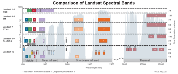
This image shows the spectral bandpasses for the sensors on all Landsat satellites.
Landsat 2
Landsat 2 continued with its sibling satellite, Landsat 1, to observe the Earth together from a unique vantage point.
Media

Sources/Usage: Public Domain. View Media Details
When the Earth-observing satellite program began, the plan was to build a series of remote-sensing spacecrafts. Without continuous observation via satellite, there would be a lapse in data which would interrupt science. Earth Resource Technology Satellite B (ERTS-B) was launched onboard a Delta 2910 rocket from Vandenberg Air Force Base, California on January 22, 1975.
Upon beginning orbit, it was renamed Landsat 2. Landsat 2 outlived the one-year design, lasting seven years. After February 28, 1982, Landsat 2 was removed from operations due to yaw control problems. It was officially decommissioned on July 27, 1983.
Instead of only principal investigators using the data that happened during Landsat 1 and the LPIP, a cooperative agriculture inventory experiment began monitoring crops around the world. Congress directed the U.S. Department of Agriculture (USDA) and NASA to begin monitoring crop health after the Soviet Union was forced to purchase wheat from the U.S. due to a major crop failure in 1972. The Large Area Crop Inventory Experiment (LACIE) was born, run by an interagency team of federal partners comprised of USDA, NASA, and National Oceanic and Atmospheric Administration (NOAA). LACIE’s primary objective was global crop monitoring, in particular wheat production. Using Landsat data, scientists could predict crop yields within a year and year-to-year variability.
The LACIE program ended just as another agricultural endeavor began in 1979. Project Agriculture and Resources Inventory Surveys Through Aerospace Remote Sensing (AgRISTARS) was a natural successor. Federal participants in the program included USDA, NASA, U.S. Department of Commerce, U.S. Department of the Interior, and the U.S. Agency for International Development. AgRISTARS focus was beyond wheat, incorporating other crops like corn and soybeans. Within the USDA, the Foreign Agricultural Service used the data to improve global crop commodity forecasts. Both LACIE and AgRISTARS paved the way for modern digital image processing of satellite imagery.
Landsat 2 Satellite Orbit Facts
- Orbited the Earth at 917 km (570 mi) in a sun-synchronous, near-polar orbit (99.2 degrees inclination)
- Circled the Earth every 103 minutes, or about fourteen orbits a day
- Had an 18-day repeat cycle with an equatorial crossing time of 9:45 a.m. +/- 15 minutes.
- Acquired data on the Worldwide Reference System-1 (WRS-1) path/row system, with swath overlap (or sidelap) varying from 14 percent at the Equator to a maximum of approximately 85 percent at 81 degrees north or south latitude.
Landsat 2 Instruments
Landsat 2 carried the same sensors as Landsat 1: the Return Beam Vidicon (RBV) and the Multispectral Scanner System (MSS).
Media

Sources/Usage: Public Domain. View Media Details
Return Beam Vidicon (RBV)
The RBV sensor utilized vidicon tube instruments containing an electron gun that read images from a photoconductive faceplate similar to television cameras. The data stream received from the satellite was analog-to-digital preprocessed to correct for radiometric and geometric errors.
- 80 meter-ground resolution
- Three cameras operating in the following spectral bands:
- Band 1 Visible blue-green (475-575 nm)
- Band 2 Visible orange-red (580-680 nm)
- Band 3 Visible red to Near-Infrared (690-830 nm)
- Data recorded to 70 millimeter (mm) black and white film rolls
- Data: 3.5 MHz FM video
RBV data was rarely used and considered useful for engineering evaluation purposes rather than science analysis. Visit RBV Film Only for more information.
Multispectral Scanner (MSS)
The MSS sensors were line-scanning devices observing the Earth perpendicular to the orbital track. The cross-track scanning was accomplished by an oscillating mirror; six lines were scanned simultaneously in each of the four spectral bands for each mirror sweep. The forward motion of the satellite provided the along-track scan line progression.
- 80-meter ground resolution in four spectral bands:
- Band 4 Visible green (0.5 to 0.6 µm)
- Band 5 Visible red (0.6 to 0.7 µm)
- Band 6 Near-Infrared (0.7 to 0.8 µm)
- Band 7 Near-Infrared (0.8 to 1.1 µm)
- Six detectors for each spectral band provided six scan lines on each active scan
- Ground Sampling Interval (pixel size): 57 x 79 m
- Scene size: 170 km x 185 km (106 mi x 115 mi)
Visit Landsat 1-5 MSS for more information.
*In 2011, the Memory of the World Programme, administered through the United Nations Educational, Scientific and Cultural Organization (UNESCO), selected the Landsat Multispectral Scanner (MSS) datasets to be included because they are unique, irreplaceable record of the Earth’s land surfaces, shallow coastal regions, and reefs.
Landsat 2 Spacecraft Facts
Landsats 1, 2, and 3 were modified Nimbus meteorological satellites.
- Weight: approximately 953 kg (2,100 lbs)
- Overall height: 3 m (10 ft)
- Diameter: 1.5 m (5 ft)
- Solar array paddles extend out to a total of 4 m (13 ft)
- 3-axis stabilized using 4 wheels to +/-0.7° attitude control
- Twin solar array paddles (single-axis articulation)
- S-Band and Very High Frequency (VHF) communications
- Hydrazine propulsion system with 3 thrusters
Additional Resources
Landsat 2 History (NASA Landsat Science)
The Multispectral Scanner (NASA Landsat Science)
Landsat Adds to World Memory - October 2011 (USGS)
Related
Spectral Bandpasses for all Landsat Sensors
This image shows the spectral bandpasses for the sensors on all Landsat satellites.

Landsat 2 First Light Image of Drayton Valley
Landsat 2’s first light image captured Drayton Valley in Alberta, Canada on January 24, 1975. Located along Canadian Highway 22, also known as Cowboy Trail, the town’s original economy thrived on faming and logging. The discovery of the Pembina oil field in 1953 contributed to explosive growth in the sparsely populated area, w
Landsat 2’s first light image captured Drayton Valley in Alberta, Canada on January 24, 1975. Located along Canadian Highway 22, also known as Cowboy Trail, the town’s original economy thrived on faming and logging. The discovery of the Pembina oil field in 1953 contributed to explosive growth in the sparsely populated area, w

Landsat 2 First Light Image of Alberta Canada
Landsat 2’s first light image features a slice of Alberta, Canada, captured on January 24, 1975 on Path 047 Row 023. This false color images uses two near infrared bands and the red band (Bands 7,6,5).
Learn more about Landsat 2 by visiting the Landsat 2 Mission Web Page
Landsat 2’s first light image features a slice of Alberta, Canada, captured on January 24, 1975 on Path 047 Row 023. This false color images uses two near infrared bands and the red band (Bands 7,6,5).
Learn more about Landsat 2 by visiting the Landsat 2 Mission Web Page
Related
Spectral Bandpasses for all Landsat Sensors
This image shows the spectral bandpasses for the sensors on all Landsat satellites.
This image shows the spectral bandpasses for the sensors on all Landsat satellites.
Landsat 2 First Light Image of Drayton Valley
Landsat 2’s first light image captured Drayton Valley in Alberta, Canada on January 24, 1975. Located along Canadian Highway 22, also known as Cowboy Trail, the town’s original economy thrived on faming and logging. The discovery of the Pembina oil field in 1953 contributed to explosive growth in the sparsely populated area, w
Landsat 2’s first light image captured Drayton Valley in Alberta, Canada on January 24, 1975. Located along Canadian Highway 22, also known as Cowboy Trail, the town’s original economy thrived on faming and logging. The discovery of the Pembina oil field in 1953 contributed to explosive growth in the sparsely populated area, w
Landsat 2 First Light Image of Alberta Canada
Landsat 2’s first light image features a slice of Alberta, Canada, captured on January 24, 1975 on Path 047 Row 023. This false color images uses two near infrared bands and the red band (Bands 7,6,5).
Learn more about Landsat 2 by visiting the Landsat 2 Mission Web Page
Landsat 2’s first light image features a slice of Alberta, Canada, captured on January 24, 1975 on Path 047 Row 023. This false color images uses two near infrared bands and the red band (Bands 7,6,5).
Learn more about Landsat 2 by visiting the Landsat 2 Mission Web Page