An official website of the United States government
Here's how you know
Official websites use .gov
A .gov website belongs to an official government organization in the United States.
Secure .gov websites use HTTPS
A lock () or https:// means you’ve safely connected to the .gov website. Share sensitive information only on official, secure websites.
Five U.S. and international stations form the core Landsat Ground Network, transmitting commands to Landsat 8 and 9 and receiving spacecraft telemetry and science data. The Landsat Ground Network ensures reliable global acquisitions and delivery of Landsat data.
The Landsat Ground Network (LGN) consists of five satellite ground stations strategically located around the world. Some are operated by United States government agencies; others are run by international space and science partners under agreements with the USGS.
Using a critical software component known as the Landsat Data Collection and Routing System (DCRS), LGN stations transmit commands to the spacecraft, receive telemetry and science data, and route these data through the Landsat Ground System for processing, archiving, and distribution.
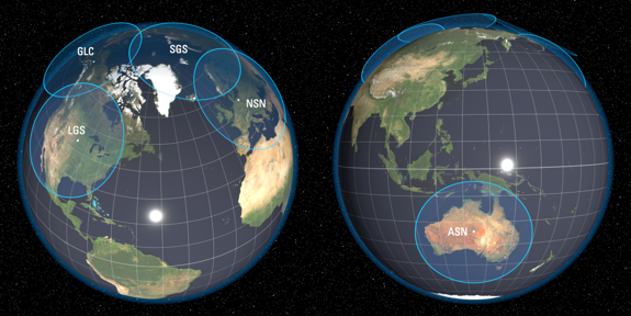
The Landsat Ground Network stations. The blue circles show the approximate satellite contact areas for the five Landsat ground stations. When Landsat passes through one of these areas, the corresponding station can communicate with the satellite and receive science and telemetry data.
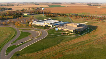
Sioux Falls, South Dakota, USA — USGS Earth Resources Observation and Science (EROS) Center
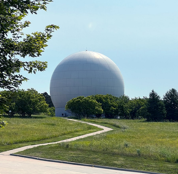
The USGS Earth Resources Observation and Science (EROS) Center.
The Landsat Ground Station (LGS) located at the USGS EROS Center is the primary Landsat ground receiving station. The Ground Network Operations Team manages coordination of all LGN stations, ensuring data are routed correctly through the ground system and coordinate all station contact scheduling.
The first antenna was installed at EROS January 1979 - a domestic satellite antenna to receive Landsat data relayed from NASA's Goddard Space Flight Center. In 1997, a dedicated 10-meter direct-downlink antenna was installed to allow EROS to function as a primary Landsat ground station. After hail destroyed the first antenna, a replacement was installed in time to receive Landsat 7 data in 1999 - covered with a golf-ball-looking radome to protect the antenna from the South Dakota weather.
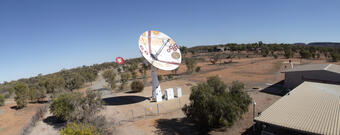
Geoscience Australia operates a centrally located ground station in Alice Springs, Australia (ASN), and supports Landsat 8 and Landsat 9 data reception.
Geoscience Australia has partnered the Landsat program since 1979.
Fairbanks, Alaska, USA — National Oceanic and Atmospheric Administration
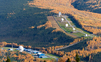
The Gilmore Creek ground station near Fairbanks, Alaska.
The National Oceanic and Atmospheric Administration (NOAA) Fairbanks Command and Data Acquisition Station at the Gilmore Creek facility (GLC) near Fairbanks, Alaska supports Landsat 8 and Landsat 9 data reception. The facility also commands and collects data from polar-orbiting and geostationary weather satellites.
GLC has partnered with the Landsat program since 1982.
The German Aerospace Center (DLR) operates the Landsat ground station in Neustrelitz, Germany (NSN), and supports Landsat 8 and Landsat 9 data reception.
DLR has partnered with the Landsat program since 1999.
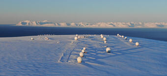
The Kongsberg Satellite Services AS (KSAT) high-latitude ground station at Svalbard (SGS) provides a vital service to many polar-orbiting satellites, including Landsat 8 and Landsat 9.
KSAT has partnered with the Landsat program since 1999.
Landsat Ground Network Station Responsibilities
As each Landsat satellite orbits the Earth in a near-polar, sun-synchronous orbit, it regularly passes within view of an LGN station. During these passes, each station establishes contact with the spacecraft to upload commands and downlink onboard data.
Because Landsat satellites orbit Earth every 99 minutes, LGN stations typically have multiple opportunities each day to contact the spacecraft. High-latitude stations such as Svalbard can see the satellite every orbit thanks to their polar vantage point, while mid-latitude stations like the USGS EROS Center in South Dakota can see the spacecraft several times each day.
LGN stations routinely uplink commands generated by the Landsat Missions Operations Center (LMOC) via an S-band radio frequency link. These commands provide a set of instructions to the spacecraft and the sensors on board, such as activating data collection by the Operational Land Imager (OLI) and Thermal Infrared Sensor (TIRS) instruments.
LGN stations use different radio frequency links to communicate with the spacecraft::
Telemetry data: Spacecraft and instrument health information is received through an S-band radio frequency link and routed to the LMOC for review.
Science data: Raw image data are received through an X-band radio frequency link and transferred to the USGS EROS Center for processing and archiving.
The Landsat International Cooperator (IC) Network includes international space and science agencies that directly receive Landsat data during satellite overpasses for regional acquisition, processing, and distribution. Some stations may also provide contingency data collection capacity to the LGN in the event of a spacecraft anomaly or malfunction.
International Cooperator stations currently receiving Landsat 8 and Landsat 9 data are located in Canada, China, Germany, India, Indonesia, and South Africa.
Map of Landsat International Ground Stations in 2026. The purple circles indicate the coverage area for stations that downlink both Landsat 8 and Landsat 9 data.
Visit the Landsat Ground Station Network webpage to view the active and historical stations that make up the Landsat Ground Network and International Cooperator Network.
Eyes on Earth Episode 129 – What Happens During a Landsat Pass?
In this episode of Eyes on Earth, we talk to ground station technicians to find out how Landsat satellite data gets from the spacecraft to EROS and then to the archive. We see what it’s like in EROS’s Landsat operations room and what the technicians do before, during, and after a Landsat pass.
In this episode of Eyes on Earth, we talk to ground station technicians to find out how Landsat satellite data gets from the spacecraft to EROS and then to the archive. We see what it’s like in EROS’s Landsat operations room and what the technicians do before, during, and after a Landsat pass.
Landsat satellites move in a polar orbit from north to south at over 27,000 kilometers per hour. For the ten meter antenna at EROS, a typical flyover, also known as a pass, lasts 14 minutes from horizon to horizon.
Landsat satellites move in a polar orbit from north to south at over 27,000 kilometers per hour. For the ten meter antenna at EROS, a typical flyover, also known as a pass, lasts 14 minutes from horizon to horizon.
Eyes on Earth Episode 81 - Tour of the EROS Radome
The Landsat satellites have been collecting Earth imagery for more than 50 years. A key piece of equipment that moves the data from the spacecraft to the archive so researchers can use it is the antenna at the EROS Center. The antenna and its radome have a fascinating history of their own that adds to the overall Landsat story.
The Landsat satellites have been collecting Earth imagery for more than 50 years. A key piece of equipment that moves the data from the spacecraft to the archive so researchers can use it is the antenna at the EROS Center. The antenna and its radome have a fascinating history of their own that adds to the overall Landsat story.
Eyes on Earth Episode 129 – What Happens During a Landsat Pass?
In this episode of Eyes on Earth, we talk to ground station technicians to find out how Landsat satellite data gets from the spacecraft to EROS and then to the archive. We see what it’s like in EROS’s Landsat operations room and what the technicians do before, during, and after a Landsat pass.
In this episode of Eyes on Earth, we talk to ground station technicians to find out how Landsat satellite data gets from the spacecraft to EROS and then to the archive. We see what it’s like in EROS’s Landsat operations room and what the technicians do before, during, and after a Landsat pass.
Landsat satellites move in a polar orbit from north to south at over 27,000 kilometers per hour. For the ten meter antenna at EROS, a typical flyover, also known as a pass, lasts 14 minutes from horizon to horizon.
Landsat satellites move in a polar orbit from north to south at over 27,000 kilometers per hour. For the ten meter antenna at EROS, a typical flyover, also known as a pass, lasts 14 minutes from horizon to horizon.
Eyes on Earth Episode 81 - Tour of the EROS Radome
The Landsat satellites have been collecting Earth imagery for more than 50 years. A key piece of equipment that moves the data from the spacecraft to the archive so researchers can use it is the antenna at the EROS Center. The antenna and its radome have a fascinating history of their own that adds to the overall Landsat story.
The Landsat satellites have been collecting Earth imagery for more than 50 years. A key piece of equipment that moves the data from the spacecraft to the archive so researchers can use it is the antenna at the EROS Center. The antenna and its radome have a fascinating history of their own that adds to the overall Landsat story.