An official website of the United States government
Here's how you know
Official websites use .gov
A .gov website belongs to an official government organization in the United States.
Secure .gov websites use HTTPS
A lock () or https:// means you’ve safely connected to the .gov website. Share sensitive information only on official, secure websites.
Located at the USGS Earth Resources Observation and Science (EROS) Center in South Dakota, the Data Processing and Archive System receives Landsat data collected through the Landsat Ground Network. The data are validated, cataloged, processed into standard Landsat science products and preserved in the USGS Landsat archive for worldwide distribution.
The USGS EROS Data Processing and Archive System (DPAS) is responsible for generating, storing and distributing all Landsat products. DPAS archives Landsat mission data according to the Information Management Services (IMS) Archive Policy.This policy ensures all data are permanently preserved by keeping a copy at the National Archive and Records Administration (NARA) facility, in an offline archive and a near-line archive.
DPAS relies on the systems and processes below to ensure consistent high-quality Landsat Level-1 products are typically generated and made available 4 to 6 hours after data acquisition.
Timeline of generating Landsat Collection 2 Level-1 and Level-2 scene-based products.
Landsat Image Assessment
The Landsat Image Assessment System (IAS) is a specialized software and engineering system that checks product quality and monitors Landsat sensor performance throughout the life of each mission. As a part of the Landsat Calibration and Validation activities, the IAS monitors and characterizes Landsat instrument performance and supports the radiometric and geometric calibration of Landsat data. The IAS also assesses the quality of the generated products by testing and updating calibration parameters used to create radiometrically and geometrically corrected products.
The IAS characterizes radiometric and geometric artifacts and captures characterization statistics in a relational database for trending, analysis, modeling, and calibration. The IAS processes up to 75 scenes per day. The IAS generates and maintains calibration information and makes several auxiliary datasets available to support product generation:
The Landsat Product Generation System (LPGS) processes raw data from Landsat satellites and generates standardized, high-quality standard operational products:
Level-1 products
Each day, the LPGS identifies new data in the Landsat inventory and verifies all necessary auxiliary data are available, applies the needed calibration parameters, and creates a final Level-1 product. Each Level-1 product includes image data stored in a 16-bit unsigned integer format, and includes quality assessment, sun angle and view angle files, browse images, and metadata files. Visit the Landsat Level-1 Processing Details webpage to view the parameters of Level-1 processing.
The LPGS provides metadata to the USGS inventory for product tracking and to support search and order capabilities through the USGS EROS data access webpages.
Level-2 Science Products
Landsat Level-2 science products are generated from Level-1 data using additional auxiliary information and advanced scientific processing algorithms. These products include Surface Reflectance, which reduces the influence of atmospheric scattering and absorption, providing an estimate of surface reflectance, and Surface Temperature, which estimates the temperature of Earth's surface.
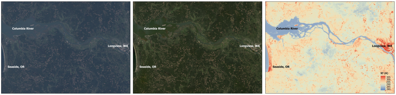
These Landsat 9 Level-1, Level-2 Surface Reflectance, and Level-2 Surface Temperature images show the Columbia River in the northwestern United States. In the natural color Level-1 image, it is easy to see aerosol scattering and haze. The natural color Landsat Surface Reflectance displays improved data quality by reducing the atmospheric effects. The Landsat Surface Temperature image displays the temperature of the Earth’s surface in Kelvin. Visit the Landsat Product Information webpage to learn more about the available Landsat products. Landsat 9 Path 47 Row 28Acquired April 14, 2025.
Level-3 Science Products
Landsat Level-3 science products, such as Burned Area, Dynamic Surface Water Extent, and Fractional Snow Covered Area, are analysis-ready products derived from Landsat U.S. Analysis Ready Data. They make it easier to evaluate landscape conditions and changes over time.
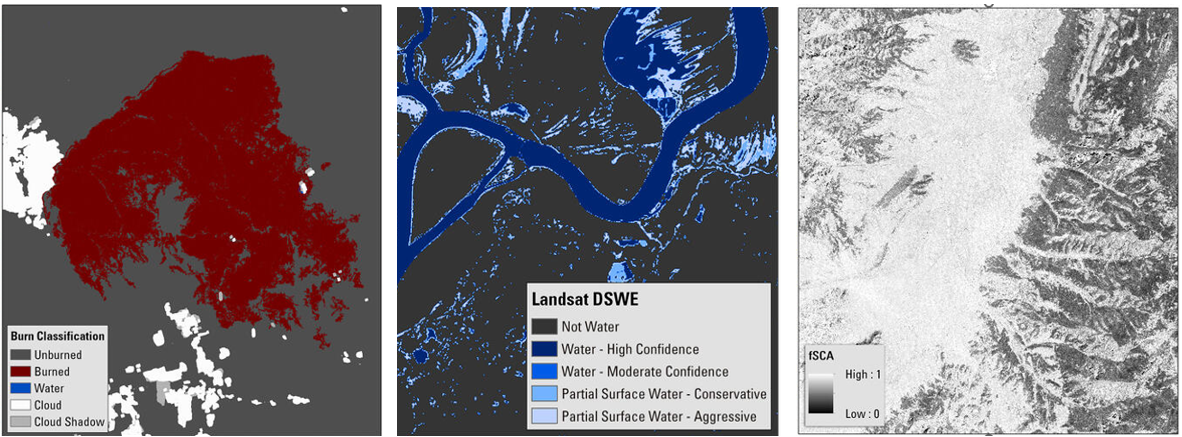
These images represent the Landsat Collection 2 Level-3 Burned Area, Dynamic Surface Water Extent, and the Fractional Snow Covered Area science products. Left: The burn classification image from the Burned Area product showing the Bootleg Fire in Oregon on July 11, 2021. Middle: The interpreted layer image from the Dynamic Surface Water product showing the confluence of the Wabash and Ohio Rivers on April 12, 2021. Right: The fractional snow covered area (fSCA) image from the fSCA product showing an area in the Dixie National Forest in Utah on February 28, 2021.
Visit the Landsat Science Products webpage to access the technical details about how all Landsat products are generated.
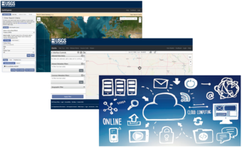
Screenshots of the USGS EROS data access portals EarthExplorer, GloVis, and an image representing the commercial cloud data access.
Landsat Archive and Data Access
Landsat Archive and Access (A&A) stores all generated products with accurate metadata and makes them available to the public through the USGS EROS data access portals and the Amazon Web Services (AWS) cloud platform. The Landsat archive contains nearly 16 petabytes (PB) of data and requires daily management. Any delay in data reception or processing affects product availability.
Landsat Level-1 products are typically available within 4 to 6 hours of acquisition. Level-2 products are generated after scenes enter Tier 1 or Tier 2 and the required auxiliary data become available. Level-3 production schedules vary by product and input-data availability.
Visit the Landsat Data Access webpage to learn more about accessing Landsat products.
This video covers EarthExplorer, or EE, which allows users to search for satellite and aerial imagery, preview browse images, export metadata, and download earth science data from the archives of the U.S. Geological Survey (USGS) Earth Resources Observation and Science (EROS) center. In this tutorial users will learn how to define an area of interest (AOI), refine your search using additional...
Landsat: Products & Services from the USGS - Webinar, September 2023
The USGS Earth Resources Observation and Science (EROS) Center maintains the largest civilian collection of images of the Earth’s land surface. At EROS we study land change and produce land change data products used by researchers, resource managers, and policymakers across the nation and around the world.
The USGS Earth Resources Observation and Science (EROS) Center maintains the largest civilian collection of images of the Earth’s land surface. At EROS we study land change and produce land change data products used by researchers, resource managers, and policymakers across the nation and around the world.
The EarthExplorer (EE) user interface is an online search, discovery, and ordering tool developed by the United States Geological Survey (USGS). EE supports the searching of satellite, aircraft, and other remote sensing inventories through interactive and textual-based query capabilities.
Landsat Collection 2 Level-2 Surface Reflectance and Surface Temperature products require Landsat Level-1 data that have been processed to Tier 1 or Tier 2 products, as well as additional auxiliary data. The Landsat Collection 2 Product Generation Timeline below gives a graphical view of this typical product generation timeframe. The timeframe for Landsat Collection 2 product generation varies due...
How long does it take to create Landsat Collection 2 Level-2 products after a Landsat scene is acquired?
Landsat Collection 2 Level-2 Surface Reflectance and Surface Temperature products require Landsat Level-1 data that have been processed to Tier 1 or Tier 2 products, as well as additional auxiliary data. The Landsat Collection 2 Product Generation Timeline below gives a graphical view of this typical product generation timeframe. The timeframe for Landsat Collection 2 product generation varies due...
There are several Landsat Collection 2 products that are useful for science applications and land use/land change studies: Landsat Level-1 Products - Each Level-1 product includes individual spectral band files, a metadata file, and additional ancillary files. Level-1 products are available for all global landmasses. Landsat U.S. Analysis Ready Data (ARD) - U.S. ARD uses Landsat Level-1 data as...
There are several Landsat Collection 2 products that are useful for science applications and land use/land change studies: Landsat Level-1 Products - Each Level-1 product includes individual spectral band files, a metadata file, and additional ancillary files. Level-1 products are available for all global landmasses. Landsat U.S. Analysis Ready Data (ARD) - U.S. ARD uses Landsat Level-1 data as...
Landsat data products held in the USGS archives can be searched and downloaded at no charge from a variety of sources. Visit Landsat Data Access for information about how Landsat data products can be downloaded individually or in bulk. Landsat imagery not found in the USGS archive might have been collected by one of the USGS International Cooperator ground stations, each of which are the primary...
Landsat data products held in the USGS archives can be searched and downloaded at no charge from a variety of sources. Visit Landsat Data Access for information about how Landsat data products can be downloaded individually or in bulk. Landsat imagery not found in the USGS archive might have been collected by one of the USGS International Cooperator ground stations, each of which are the primary...
Landsat data continue to be freely available through traditional USGS tools such as EarthExplorer, but if you prefer to access the data in the cloud, an Amazon Web Services (AWS) account is required. Landsat data are available in the cloud via the AWS Oregon us-west-2 region. There is no charge for the Landsat data, but charges from the cloud vendor might apply for any storage, processing, and...
When do I need an Amazon Web Services (AWS) account to access Landsat data in the cloud? Is there a cost for that?
Landsat data continue to be freely available through traditional USGS tools such as EarthExplorer, but if you prefer to access the data in the cloud, an Amazon Web Services (AWS) account is required. Landsat data are available in the cloud via the AWS Oregon us-west-2 region. There is no charge for the Landsat data, but charges from the cloud vendor might apply for any storage, processing, and...
Yes. Regardless of where the USGS has stored the files, Landsat data are controlled by the USGS and considered to be an official USGS record in the public domain. Permission is not required for use. We do request that you acknowledge the USGS as the source. Learn More: USGS Copyrights and Credits statement Landsat Commercial Cloud Data Access
Are Landsat data in the cloud still considered to be within the public domain?
Yes. Regardless of where the USGS has stored the files, Landsat data are controlled by the USGS and considered to be an official USGS record in the public domain. Permission is not required for use. We do request that you acknowledge the USGS as the source. Learn More: USGS Copyrights and Credits statement Landsat Commercial Cloud Data Access
This video covers EarthExplorer, or EE, which allows users to search for satellite and aerial imagery, preview browse images, export metadata, and download earth science data from the archives of the U.S. Geological Survey (USGS) Earth Resources Observation and Science (EROS) center. In this tutorial users will learn how to define an area of interest (AOI), refine your search using additional...
Landsat: Products & Services from the USGS - Webinar, September 2023
The USGS Earth Resources Observation and Science (EROS) Center maintains the largest civilian collection of images of the Earth’s land surface. At EROS we study land change and produce land change data products used by researchers, resource managers, and policymakers across the nation and around the world.
The USGS Earth Resources Observation and Science (EROS) Center maintains the largest civilian collection of images of the Earth’s land surface. At EROS we study land change and produce land change data products used by researchers, resource managers, and policymakers across the nation and around the world.
The EarthExplorer (EE) user interface is an online search, discovery, and ordering tool developed by the United States Geological Survey (USGS). EE supports the searching of satellite, aircraft, and other remote sensing inventories through interactive and textual-based query capabilities.
Landsat Collection 2 Level-2 Surface Reflectance and Surface Temperature products require Landsat Level-1 data that have been processed to Tier 1 or Tier 2 products, as well as additional auxiliary data. The Landsat Collection 2 Product Generation Timeline below gives a graphical view of this typical product generation timeframe. The timeframe for Landsat Collection 2 product generation varies due...
How long does it take to create Landsat Collection 2 Level-2 products after a Landsat scene is acquired?
Landsat Collection 2 Level-2 Surface Reflectance and Surface Temperature products require Landsat Level-1 data that have been processed to Tier 1 or Tier 2 products, as well as additional auxiliary data. The Landsat Collection 2 Product Generation Timeline below gives a graphical view of this typical product generation timeframe. The timeframe for Landsat Collection 2 product generation varies due...
There are several Landsat Collection 2 products that are useful for science applications and land use/land change studies: Landsat Level-1 Products - Each Level-1 product includes individual spectral band files, a metadata file, and additional ancillary files. Level-1 products are available for all global landmasses. Landsat U.S. Analysis Ready Data (ARD) - U.S. ARD uses Landsat Level-1 data as...
There are several Landsat Collection 2 products that are useful for science applications and land use/land change studies: Landsat Level-1 Products - Each Level-1 product includes individual spectral band files, a metadata file, and additional ancillary files. Level-1 products are available for all global landmasses. Landsat U.S. Analysis Ready Data (ARD) - U.S. ARD uses Landsat Level-1 data as...
Landsat data products held in the USGS archives can be searched and downloaded at no charge from a variety of sources. Visit Landsat Data Access for information about how Landsat data products can be downloaded individually or in bulk. Landsat imagery not found in the USGS archive might have been collected by one of the USGS International Cooperator ground stations, each of which are the primary...
Landsat data products held in the USGS archives can be searched and downloaded at no charge from a variety of sources. Visit Landsat Data Access for information about how Landsat data products can be downloaded individually or in bulk. Landsat imagery not found in the USGS archive might have been collected by one of the USGS International Cooperator ground stations, each of which are the primary...
Landsat data continue to be freely available through traditional USGS tools such as EarthExplorer, but if you prefer to access the data in the cloud, an Amazon Web Services (AWS) account is required. Landsat data are available in the cloud via the AWS Oregon us-west-2 region. There is no charge for the Landsat data, but charges from the cloud vendor might apply for any storage, processing, and...
When do I need an Amazon Web Services (AWS) account to access Landsat data in the cloud? Is there a cost for that?
Landsat data continue to be freely available through traditional USGS tools such as EarthExplorer, but if you prefer to access the data in the cloud, an Amazon Web Services (AWS) account is required. Landsat data are available in the cloud via the AWS Oregon us-west-2 region. There is no charge for the Landsat data, but charges from the cloud vendor might apply for any storage, processing, and...
Yes. Regardless of where the USGS has stored the files, Landsat data are controlled by the USGS and considered to be an official USGS record in the public domain. Permission is not required for use. We do request that you acknowledge the USGS as the source. Learn More: USGS Copyrights and Credits statement Landsat Commercial Cloud Data Access
Are Landsat data in the cloud still considered to be within the public domain?
Yes. Regardless of where the USGS has stored the files, Landsat data are controlled by the USGS and considered to be an official USGS record in the public domain. Permission is not required for use. We do request that you acknowledge the USGS as the source. Learn More: USGS Copyrights and Credits statement Landsat Commercial Cloud Data Access