
USGS Science Collaboration Portal for the Colorado River Basin
Collaboration platform that brings together science, data, and mapping and analytical tools from across the basin
Collaboration platform that brings together science, data, and mapping and analytical tools from across the basin
Colorado River Basin Actionable and Strategic Integrated Science and Technology (ASIST) Initiative
Fostering Innovative Interdisciplinary Science for Characterizing and Adapting to Long-term Drought
Fostering Innovative Interdisciplinary Science for Characterizing and Adapting to Long-term Drought
Colorado River Basin Drought and the 2023 Water Year
Geonarrative presentation comparing 2023 conditions to the long-term drought in the Colorado River Basin
Geonarrative presentation comparing 2023 conditions to the long-term drought in the Colorado River Basin
Great Salt Lake Data and Reports by the USGS
Learn about Water Quantity and Quality and Aquatic Ecology of this National Treasure
Learn about Water Quantity and Quality and Aquatic Ecology of this National Treasure
Colorado River Basin Studies in Utah
Learn about Surface Water, Groundwater Quantities and Quality and Artificial Recharge of Groundwater in the Colorado River Basin in Utah
Learn about Surface Water, Groundwater Quantities and Quality and Artificial Recharge of Groundwater in the Colorado River Basin in Utah
Streamflow in the Upper Rio Grande Basin
USGS Analyses of the Effects of Potential Future Climate Conditions on Streamflows in the Upper Rio Grande Basin
USGS Analyses of the Effects of Potential Future Climate Conditions on Streamflows in the Upper Rio Grande Basin
Next Generation Water Observing System (NGWOS) Study: Upper Colorado River Basin
The USGS NGWOS Program Provides Innovative, High-fidelity, Real-time Data and Insightful Analyses about Water Quantity, Quality, and Use in Selected Watersheds across the U.S.
The USGS NGWOS Program Provides Innovative, High-fidelity, Real-time Data and Insightful Analyses about Water Quantity, Quality, and Use in Selected Watersheds across the U.S.
Rocky Mountain Region
USGS Region 7 Staff support and advise USGS Science Centers that provide numerous stakeholders with vital information about spatial distribution and temporal trends in critical minerals, energy resources, geology, water resources, native plants and wildlife, and hazards posed by earthquakes and landslides in Colorado, New Mexico, Utah, Wyoming and beyond.
USGS Region 7: Upper Colorado Basin (Rocky Mountain)
USGS Region 7: Upper Colorado Basin (Rocky Mountain)

Map Showing USGS/DOI Unified Region 7 and adjoining Regions
Key USGS Region 7 Contacts
Key USGS Region 7 Contacts
Additional Information about USGS Region 7
Additional Information about USGS Region 7
News
New Nationwide Tool Helps Answer: Do We Have Enough Water?
New Nationwide Tool Helps Answer: Do We Have Enough Water?
FORT Updates: From Plains to Peaks - Vol. 4 | Issue 1
FORT Updates: From Plains to Peaks - Vol. 4 | Issue 1
New tree-ring science demonstrates successful restoration of historical fire patterns in two southwestern wilderness areas
New tree-ring science demonstrates successful restoration of historical fire patterns in two southwestern wilderness areas
Publications
Determination of baseline water-quality conditions using continuous specific conductance and discrete measurements of total dissolved solids and selected major ions, Arkansas River Basin, Colorado Determination of baseline water-quality conditions using continuous specific conductance and discrete measurements of total dissolved solids and selected major ions, Arkansas River Basin, Colorado
From 2022 through 2024, the U.S. Geological Survey (USGS) in cooperation with the Regional Resources Planning Group (Southeastern Colorado Water Conservancy District, Colorado Springs Utilities, Pueblo Water, Lower Arkansas Valley Water Conservancy District, Aurora Water, and Upper Arkansas Water Conservancy District) established a basinwide water-quality monitoring network in the...
Mercury biomagnification across food webs with varying non-native fish presence: Implications for native fish conservation in the upper Colorado River Basin Mercury biomagnification across food webs with varying non-native fish presence: Implications for native fish conservation in the upper Colorado River Basin
Environmental contaminants and non-native species introductions negatively affect aquatic ecosystem conservation. Mercury (Hg) accumulates within food webs where it can biomagnify to toxic concentrations, which can be affected by altered trophic relationships from non-native species. This study examined Hg concentrations (n samples = 655) and stable carbon and nitrogen isotope (n = 746)
Mid-Cretaceous porphyritic magmatism in the Beartooth Mountains of the northern Laramide foreland and its connection to Frontier Formation sediment dispersal in Bighorn basin, Montana-Wyoming (USA), and Cordilleran tectonism Mid-Cretaceous porphyritic magmatism in the Beartooth Mountains of the northern Laramide foreland and its connection to Frontier Formation sediment dispersal in Bighorn basin, Montana-Wyoming (USA), and Cordilleran tectonism
Porphyritic intrusions in the southeast Beartooth Mountains and porphyritic cobbles from the Torchlight conglomerate of the Cenomanian Frontier Formation in Bighorn basin (Montana-Wyoming, USA) bear striking resemblance. We utilize geologic mapping, petrography, geochemistry, and geochronology to characterize rocks from both locations and test whether the Beartooth Mountains area was the
Science
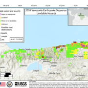
2026 Venezuela Sequence Earthquake-Triggered Landslide Hazards
On Wednesday, June 24th, 2026, a pair of earthquakes of Magnitude 7.2 and Magnitude 7.5 occurred in northern Venezuela, west of Caracas. The U.S. Geological Survey (USGS) Ground Failure product estimated that landslides triggered by this earthquake would likely be significant in number and/or spatial extent. This landslide event page serves to communicate timely science information to our partners...

Modernized Breeding Bird Survey Portal
The North American Breeding Bird Survey (BBS) Portal is a modern information system that enables volunteer observers and regional coordinators to manage survey routes, enter field data, and coordinate route assignments online. The portal replaces legacy paper-based and outdated digital workflows with a streamlined interface built for the BBS community. Observers can view their assigned routes...

Water Quality
The USGS, in partnership with multiple other groups, is learning about water-quality conditions across time and space in terminal lakes across the Great Basin. This effort is part of the Saline Lake Ecosystems Integrated Water Availability Assessment.