Group Installed Coast Cam in Puerto Rico
Detailed Description
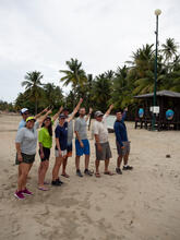
A team from the USGS St. Petersburg Coastal and Marine Science Center went to Puerto Rico to install new Coast Cams to monitor how the beach and shoreline change through time. These cameras will allow the team to make predictions of how the coast will respond during storms and hurricanes.
They are also deploying oceanographic buoys to measure wave conditions, water level, and wind estimates. These data will be used to validate numerical models for future expansion of the Total Water Level and Coastal Change Forecast.
From left to right: Mark Buckley, Legna Torres-Garcia, Priscila Vargas-Babilonia (Student Services Contractor), Meg Palmsten, Dave Thompson, Justin Birchler, BJ Reynolds, and Luis Perez-Squeo (Student Services Contractor).
Sources/Usage
Used with permission from Priscila Vargas-Babilonia and Luis Perez-Squeo.
Related Content
Using Video Imagery to Study Wave Dynamics: Tres Palmas
Using Video Imagery to Study Wave Dynamics: Isla Verde
Operational Total Water Level and Coastal Change Forecasts
Total Water Level and Coastal Change Forecast Viewer
Total water level (TWL) at the shoreline is the combination of tides, surge, and wave runup. A forecast of TWL is an estimate of the elevation where the ocean will meet the coast and can provide guidance on potential coastal erosion and flooding hazards.
Real-Time Forecasts of Coastal Change
U.S. Geological Survey researchers develop tools to forecast coastal change hazards. This geonarrative features research and tools developed to forecast real-time coastal change.
Related Content
- Science
Puerto Rico Natural Hazards: Coastal | Peligros naturales de Puerto Rico: Costas
This page is a collection of USGS coastal hazard research in Puerto Rico, including shoreline changes, coral reef assessments, and coastal flooding. A brief description of highlighted projects can be found below. All coastal hazard publications, data releases, and news for Puerto Rico can be accessed on this page. Esta página es una recopilación de investigaciones del USGS sobre los riesgos...Using Video Imagery to Study Wave Dynamics: Tres Palmas
To study wave dynamics along an active coastline, video cameras were installed on the west coast of Puerto Rico at Tres Palmas in Rincón.Using Video Imagery to Study Wave Dynamics: Isla Verde
USGS scientists installed video cameras atop a building and oceanographic instruments off San Juan, Puerto Rico, to better understand how waves move across coral reefs and cause flooding on tropical shorelines.Operational Total Water Level and Coastal Change Forecasts
The viewer shows predictions of the timing and magnitude of water levels at the shoreline and potential impacts to coastal dunes. - Data
Total Water Level and Coastal Change Forecast Viewer
Total water level (TWL) at the shoreline is the combination of tides, surge, and wave runup. A forecast of TWL is an estimate of the elevation where the ocean will meet the coast and can provide guidance on potential coastal erosion and flooding hazards.
ByNatural Hazards Mission Area, Water Resources Mission Area, Coastal and Marine Hazards and Resources Program, St. Petersburg Coastal and Marine Science Center, Hurricane Dorian, Hurricane Florence, Hurricane Harvey, Hurricane Irma, Hurricane Isaias, Hurricane Jose, Hurricane Laura, Hurricane Marco, Hurricane Maria, Hurricane Matthew, Hurricane Michael, Hurricane Nate, Hurricane Sandy, Hurricanes - Web Tools
Real-Time Forecasts of Coastal Change
U.S. Geological Survey researchers develop tools to forecast coastal change hazards. This geonarrative features research and tools developed to forecast real-time coastal change.