
View of a recently installed Restoration Field Trial Network site in the rangelands of Northern Arizona.
Images
See our science through the images below.
Filter Total Items: 3543

Seeding treatment experiment
View of a recently installed Restoration Field Trial Network site in the rangelands of Northern Arizona.

Pallid bat with transmitter
A Pallid bat (Antrozous pallidus) is outfitted with a radio transmitter to help lead us to its roost. The transmitter is attached with a temporary adhesive that will wear off within around 2 weeks, about as long as the battery life of the transmitter lasts.
A Pallid bat (Antrozous pallidus) is outfitted with a radio transmitter to help lead us to its roost. The transmitter is attached with a temporary adhesive that will wear off within around 2 weeks, about as long as the battery life of the transmitter lasts.

RestoreNet garden testing seedling establishment.
The RestoreNet gardens test seedlings of priority restoration species across the Southwest. This is a recently installed garden located in the juniper woodlands of the Colorado Plateau. The experiemental network will support land managers by providing insight into various restoration techniques, including testing seedlings vs seeds.
The RestoreNet gardens test seedlings of priority restoration species across the Southwest. This is a recently installed garden located in the juniper woodlands of the Colorado Plateau. The experiemental network will support land managers by providing insight into various restoration techniques, including testing seedlings vs seeds.

Setting up radar system near a wind energy field in Colorado.
Setting up radar system near a wind energy field in Colorado.Image of scientist setting up a radar system in Colorado to test its efficacy in detecting birds and bats flying towards spinning wind turbines.
Setting up radar system near a wind energy field in Colorado.
Setting up radar system near a wind energy field in Colorado.Image of scientist setting up a radar system in Colorado to test its efficacy in detecting birds and bats flying towards spinning wind turbines.

Assessing fish habitat and population dynamics of fisheries resources
Assessing fish habitat and population dynamics of fisheries resourcesThroughout Hawaii, fishponds are considered by their local communities as important cultural touchstones, a source of local, sustainably produced food, and an important component to the development of community-based management for nearshore fisheries.

Assessing the Functional Equivalency of Hawaiian fishponds
Assessing the Functional Equivalency of Hawaiian fishpondsHawaiian fishponds were important cultural and economic resources for native Hawaiians as they were an important component of a sophisticated, integrated food production system. However, changing demographics and systems of land ownership resulted in a decline in the use and upkeep of Hawaiian fishponds throughout the 19th century.

Western Bumble Bee
Many bumble bee species have declined in recent decades due to changes in habitat, climate, and pressures from pathogens, pesticides and introduced species. The western bumble bee, once common throughout western North America, is a species of concern and is being considered for listing by the U.S. Fish and Wildlife Service under the Endangered Species Act.
Many bumble bee species have declined in recent decades due to changes in habitat, climate, and pressures from pathogens, pesticides and introduced species. The western bumble bee, once common throughout western North America, is a species of concern and is being considered for listing by the U.S. Fish and Wildlife Service under the Endangered Species Act.

Gulf Coast South of Lafayette, LA
View of the barrier islands off Lafayette, LA while conducting low-level aerial seabird surveys in the Gulf of Mexico, as part of the GoMMAPPS project.
View of the barrier islands off Lafayette, LA while conducting low-level aerial seabird surveys in the Gulf of Mexico, as part of the GoMMAPPS project.

Oil Platform
Oil platform in the Gulf of Mexico viewed as part of GoMMAPPS aerial surveys for seabirds.
Oil platform in the Gulf of Mexico viewed as part of GoMMAPPS aerial surveys for seabirds.

Adult Female Northern Harrier (Circus cyaneus)
An adult, female northern harrier (Circus cyaneus) flies overhead in Suisun Marsh, CA. Before habitat loss drove declines in the bird's populations, Suisun Marsh hosted the state's largest population of northern harriers.
An adult, female northern harrier (Circus cyaneus) flies overhead in Suisun Marsh, CA. Before habitat loss drove declines in the bird's populations, Suisun Marsh hosted the state's largest population of northern harriers.

Endangered Salt Marsh Harvest Mouse (Reithrodontomys raviventris)
Endangered Salt Marsh Harvest Mouse (Reithrodontomys raviventris)A Federally endangered salt marsh harvest mouse (Reithrodontomys raviventris) climbs a branch.
Endangered Salt Marsh Harvest Mouse (Reithrodontomys raviventris)
Endangered Salt Marsh Harvest Mouse (Reithrodontomys raviventris)A Federally endangered salt marsh harvest mouse (Reithrodontomys raviventris) climbs a branch.

Adult Male Northern Harrier (Circus cyaneus)
An adult male Northern Harrier (Circus cyaneus) surveys Suisun Marsh, CA. Males are known for their beautiful, steel-gray plumage.
An adult male Northern Harrier (Circus cyaneus) surveys Suisun Marsh, CA. Males are known for their beautiful, steel-gray plumage.

Tree cores ready for dendrological analysis
These tree cores, taken from living trees with an increment borer, show the rings of the tree and allow scientists to learn about the tree's growth.
These tree cores, taken from living trees with an increment borer, show the rings of the tree and allow scientists to learn about the tree's growth.

Horned Lark Nest with Newly Hatched Nestlings
Photograph of a Horned Lark nest with newly hatched nestlings. Nest was found in Phillips County, Montana near S. Wagner Road.
Photograph of a Horned Lark nest with newly hatched nestlings. Nest was found in Phillips County, Montana near S. Wagner Road.
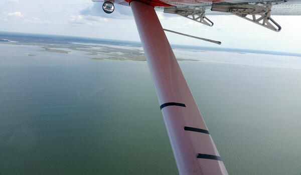
Aerial Survey Wing Markings
Standard wing markings on a US Fish and Wildlife Service Kodiak amphibious aircraft used to denote strip-transect distance bands to aid observers in data collection for the GoMMAPPS aerial seabird surveys from 2017-2020 and 2022-2023.
Standard wing markings on a US Fish and Wildlife Service Kodiak amphibious aircraft used to denote strip-transect distance bands to aid observers in data collection for the GoMMAPPS aerial seabird surveys from 2017-2020 and 2022-2023.

Lark Bunting Nest with Four Eggs
Photograph of a Lark Bunting nest with four eggs. Nest was found in Phillips County, Montana.
Photograph of a Lark Bunting nest with four eggs. Nest was found in Phillips County, Montana.

Ocean through the belly of the plane
A view through the belly port of a plane while cameras collect images during an aerial photographic survey.
The Seabird Studies Team at the USGS Western Ecological Research Center is conducting aerial photographic surveys of the ocean off central and southern California to create comprehensive maps of seabird and marine mammal distributions.

Drainage pipe being installed in wetland catchment
Drainage pipe being installed in wetland catchmentTile drainage pipe being installed in wetland catchment to reduce water inflow into a wetland basin in North Dakota.
Drainage pipe being installed in wetland catchment
Drainage pipe being installed in wetland catchmentTile drainage pipe being installed in wetland catchment to reduce water inflow into a wetland basin in North Dakota.

Surveying breeding birds
Biological Science Technician surveying breeding birds on a grassland managed by the U.S. Fish and Wildlife Service.
Biological Science Technician surveying breeding birds on a grassland managed by the U.S. Fish and Wildlife Service.

A scientist extracts a core from a charred ponderosa pine
A scientist extracts a core from a charred ponderosa pineUSGS scientist Zach Wenderott extracts a tree core from a charred ponderosa pine in Lassen National Park as part of a study of how prescribed fire influences tree growth.
A scientist extracts a core from a charred ponderosa pine
A scientist extracts a core from a charred ponderosa pineUSGS scientist Zach Wenderott extracts a tree core from a charred ponderosa pine in Lassen National Park as part of a study of how prescribed fire influences tree growth.

Missouri River Land cover map
Land cover map of an area of the Missouri River used to classify potential breeding habitat for least terns and piping plovers on emergent sandbars.
Land cover map of an area of the Missouri River used to classify potential breeding habitat for least terns and piping plovers on emergent sandbars.