



The photograph shows a spider unit, which is being used to help study the landslide that occurred in northwest Washington on March 22, 2014. Spiders are portable instrumentation packages that contain high-precision GPS units for detecting landslide movement as well as geophones for detecting small vibrations. The spiders can be emplaced by hovering helicopters.
Images
Images related to natural hazards.
Filter Total Items: 7278

Spider Unit & 2014 Washington Landslide
The photograph shows a spider unit, which is being used to help study the landslide that occurred in northwest Washington on March 22, 2014. Spiders are portable instrumentation packages that contain high-precision GPS units for detecting landslide movement as well as geophones for detecting small vibrations. The spiders can be emplaced by hovering helicopters.

USGS tilt current meter (white cylinder) in overwash channel
USGS tilt current meter (white cylinder) in overwash channelUSGS tilt current meter (white cylinder) in overwash channel in the Sandwich Town Beach flooded during a Nor'Easter in March 2014
USGS tilt current meter (white cylinder) in overwash channel
USGS tilt current meter (white cylinder) in overwash channelUSGS tilt current meter (white cylinder) in overwash channel in the Sandwich Town Beach flooded during a Nor'Easter in March 2014

2014 Landslide in Washington State
Photograph from aerial survey showing the upper parts of the landslide that occurred in northwest Washington on March 22, 2014.
Photograph from aerial survey showing the upper parts of the landslide that occurred in northwest Washington on March 22, 2014.

2014 Landslide in Washington State
Photograph from an aerial survey showing the extent and impacts from the landslide in northwest Washington that occurred on March 22, 2014. The survey was conducted by the Washington State Department of Transportation, Washington State Department of Natural Resources, USGS, and King County Sheriff's Office.
Photograph from an aerial survey showing the extent and impacts from the landslide in northwest Washington that occurred on March 22, 2014. The survey was conducted by the Washington State Department of Transportation, Washington State Department of Natural Resources, USGS, and King County Sheriff's Office.

2014 Landslide in Washington State
Photograph from an aerial survey showing the extent and impacts from the landslide in northwest Washington that occurred on March 22, 2014. The survey was conducted by the Washington State Department of Transportation, Washington State Department of Natural Resources, USGS, and King County Sheriff's Office.
Photograph from an aerial survey showing the extent and impacts from the landslide in northwest Washington that occurred on March 22, 2014. The survey was conducted by the Washington State Department of Transportation, Washington State Department of Natural Resources, USGS, and King County Sheriff's Office.

2014 Landslide in Washington State
Photograph from an aerial survey showing the extent and impacts from the landslide in northwest Washington that occurred on March 22, 2014. The survey was conducted by the Washington State Department of Transportation, Washington State Department of Natural Resources, USGS, and King County Sheriff's Office.
Photograph from an aerial survey showing the extent and impacts from the landslide in northwest Washington that occurred on March 22, 2014. The survey was conducted by the Washington State Department of Transportation, Washington State Department of Natural Resources, USGS, and King County Sheriff's Office.

2014 Landslide in Washington State
Photograph from an aerial survey showing the extent and impacts from the landslide in northwest Washington that occurred on March 22, 2014. The survey was conducted by the Washington State Department of Transportation, Washington State Department of Natural Resources, USGS, and King County Sheriff's Office.
Photograph from an aerial survey showing the extent and impacts from the landslide in northwest Washington that occurred on March 22, 2014. The survey was conducted by the Washington State Department of Transportation, Washington State Department of Natural Resources, USGS, and King County Sheriff's Office.

2014 Landslide in Washington State
Photograph from an aerial survey showing the extent and impacts from the landslide in northwest Washington that occurred on March 22, 2014. The survey was conducted by the Washington State Department of Transportation, Washington State Department of Natural Resources, USGS, and King County Sheriff's Office.
Photograph from an aerial survey showing the extent and impacts from the landslide in northwest Washington that occurred on March 22, 2014. The survey was conducted by the Washington State Department of Transportation, Washington State Department of Natural Resources, USGS, and King County Sheriff's Office.

2014 Landslide in Washington State
Photograph from an aerial survey showing the extent and impacts from the landslide in northwest Washington that occurred on March 22, 2014. The survey was conducted by the Washington State Department of Transportation, Washington State Department of Natural Resources, USGS, and King County Sheriff's Office.
Photograph from an aerial survey showing the extent and impacts from the landslide in northwest Washington that occurred on March 22, 2014. The survey was conducted by the Washington State Department of Transportation, Washington State Department of Natural Resources, USGS, and King County Sheriff's Office.

Kahauale‘a 2 flow and lava pond in Pu‘u ‘Ō‘ō remain active
Kahauale‘a 2 flow and lava pond in Pu‘u ‘Ō‘ō remain activeMar 21, 2014: The Kahauale‘a 2 flow remains active, with the active flow front slowly moving through thick forest northeast of Pu‘u ‘Ō‘ō. The flow front today was 8.2 km (5.1 miles) northeast of the vent on Pu‘u ‘Ō‘ō, which is visible in the center of the photograph, although partly obscured by fume and smoke from burning trees.
Kahauale‘a 2 flow and lava pond in Pu‘u ‘Ō‘ō remain active
Kahauale‘a 2 flow and lava pond in Pu‘u ‘Ō‘ō remain activeMar 21, 2014: The Kahauale‘a 2 flow remains active, with the active flow front slowly moving through thick forest northeast of Pu‘u ‘Ō‘ō. The flow front today was 8.2 km (5.1 miles) northeast of the vent on Pu‘u ‘Ō‘ō, which is visible in the center of the photograph, although partly obscured by fume and smoke from burning trees.

(Right) Spattering at the edge of the pond during the fall cycle.
(Right) Spattering at the edge of the pond during the fall cycle.(Right) Spattering at the edge of the pond during the fall cycle.
(Right) Spattering at the edge of the pond during the fall cycle.
(Right) Spattering at the edge of the pond during the fall cycle.(Right) Spattering at the edge of the pond during the fall cycle.

Lava lake activity in Halema‘uma‘u continues
Mar 21, 2014: The lava lake at the summit of Kīlauea Volcano remains active. During our observation today, the lava lake surface was about 40 m (131 ft) below the rim of the vent (the Overlook crater) within Halema‘uma‘u Crater.
Mar 21, 2014: The lava lake at the summit of Kīlauea Volcano remains active. During our observation today, the lava lake surface was about 40 m (131 ft) below the rim of the vent (the Overlook crater) within Halema‘uma‘u Crater.

Mar 21, 2014: The lava pond surface at its highest level observed ...
Mar 21, 2014: The lava pond surface at its highest level observed ...Mar 21, 2014: (Left) The lava pond surface at its highest level observed during our field work today—just before the release of gas caused it to drop during the fall cycle of the gas pistoning.
Mar 21, 2014: The lava pond surface at its highest level observed ...
Mar 21, 2014: The lava pond surface at its highest level observed ...Mar 21, 2014: (Left) The lava pond surface at its highest level observed during our field work today—just before the release of gas caused it to drop during the fall cycle of the gas pistoning.

Mar 21, 2014: The small (10 meters, or 30 feet, wide) lava pond wit...
Mar 21, 2014: The small (10 meters, or 30 feet, wide) lava pond wit...Mar 21, 2014: The small (10 meters, or 30 feet, wide) lava pond within the northeast spatter cone on Pu‘u ‘Ō‘ō experiences cyclic rises and falls of the lava surface called "gas pistoning," driven by the buildup and release of gas in the pond. At the time of this photograph, the pond surface had dropped following the release of gas.
Mar 21, 2014: The small (10 meters, or 30 feet, wide) lava pond wit...
Mar 21, 2014: The small (10 meters, or 30 feet, wide) lava pond wit...Mar 21, 2014: The small (10 meters, or 30 feet, wide) lava pond within the northeast spatter cone on Pu‘u ‘Ō‘ō experiences cyclic rises and falls of the lava surface called "gas pistoning," driven by the buildup and release of gas in the pond. At the time of this photograph, the pond surface had dropped following the release of gas.

Mar 21, 2014: The release of gas from the lava pond at Pu‘u ‘Ō‘ō n...
Mar 21, 2014: The release of gas from the lava pond at Pu‘u ‘Ō‘ō n...Mar 21, 2014: The release of gas from the lava pond at Pu‘u ‘Ō‘ō nearly obscures the spatter (fluid fragments of molten lava) being thrown about a meter (3 ft) high.
Mar 21, 2014: The release of gas from the lava pond at Pu‘u ‘Ō‘ō n...
Mar 21, 2014: The release of gas from the lava pond at Pu‘u ‘Ō‘ō n...Mar 21, 2014: The release of gas from the lava pond at Pu‘u ‘Ō‘ō nearly obscures the spatter (fluid fragments of molten lava) being thrown about a meter (3 ft) high.
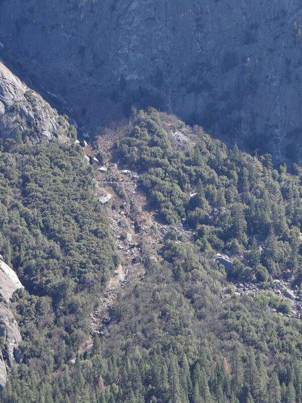
Landslide Detail below Moran Point
In this image, a landslide may be seen in detail below Moran Point in Yosemite Valley. The broken rock fragments are often referred to as talus deposits or scree.
In this image, a landslide may be seen in detail below Moran Point in Yosemite Valley. The broken rock fragments are often referred to as talus deposits or scree.
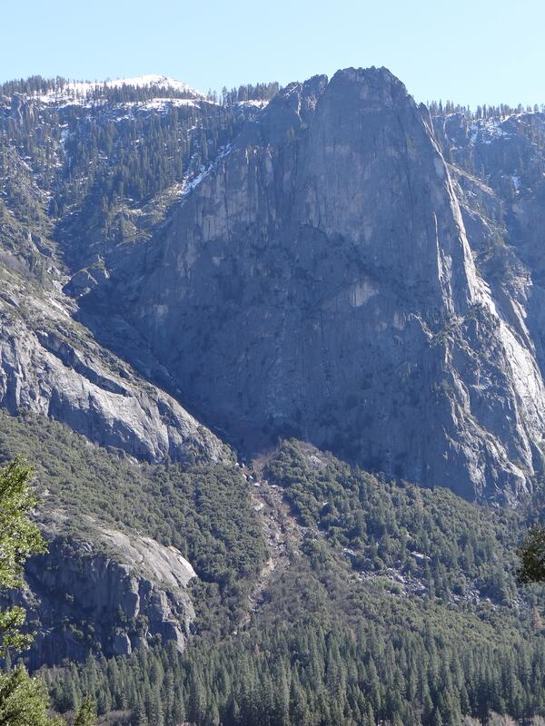
Landslide below Moran Point
In this image, a landslide may be seen below Moran Point in Yosemite Valley. The broken rock fragments are often referred to as talus deposits or scree.
In this image, a landslide may be seen below Moran Point in Yosemite Valley. The broken rock fragments are often referred to as talus deposits or scree.

Mar 7, 2014: active flow front, which is burning forest and causing...
Mar 7, 2014: active flow front, which is burning forest and causing...Mar 7, 2014: Another view of the active flow front, which is burning forest and causing scattered fires. Mauna Loa (left) and Mauna Kea (right, with a snow-covered summit) are on the skyline in this wide photograph. At the very left edge of the photo, the plume from Kīlauea's summit lava lake can be seen.
Mar 7, 2014: active flow front, which is burning forest and causing...
Mar 7, 2014: active flow front, which is burning forest and causing...Mar 7, 2014: Another view of the active flow front, which is burning forest and causing scattered fires. Mauna Loa (left) and Mauna Kea (right, with a snow-covered summit) are on the skyline in this wide photograph. At the very left edge of the photo, the plume from Kīlauea's summit lava lake can be seen.

Mar 7, 2014: lava pond in Pu‘u ‘Ō‘ō, with snow-covered Mauna Kea in...
Mar 7, 2014: lava pond in Pu‘u ‘Ō‘ō, with snow-covered Mauna Kea in...Mar 7, 2014: A close-up of the lava pond in Pu‘u ‘Ō‘ō crater, with snow-covered Mauna Kea in the distance.
Mar 7, 2014: lava pond in Pu‘u ‘Ō‘ō, with snow-covered Mauna Kea in...
Mar 7, 2014: lava pond in Pu‘u ‘Ō‘ō, with snow-covered Mauna Kea in...Mar 7, 2014: A close-up of the lava pond in Pu‘u ‘Ō‘ō crater, with snow-covered Mauna Kea in the distance.

Continued lava lake activity in Halema‘uma‘u
Mar 7, 2014: The lava lake in the Overlook crater, within Halema‘uma‘u Crater, at Kīlauea's summit remains active. Today, winds carried the plume towards the north, providing a clear view of the persistent spattering area in the southeast portion of the lake.
Mar 7, 2014: The lava lake in the Overlook crater, within Halema‘uma‘u Crater, at Kīlauea's summit remains active. Today, winds carried the plume towards the north, providing a clear view of the persistent spattering area in the southeast portion of the lake.

Kahauale‘a 2 flow still moving through forest NE of Pu‘u ‘Ō‘ō
Kahauale‘a 2 flow still moving through forest NE of Pu‘u ‘Ō‘ōMar 7, 2014: The Kahauale‘a 2 flow remains active, and the active flow front is moving through thick forest northeast of Pu‘u ‘Ō‘ō. The flow front today was 7.9 km (4.9 miles) northeast of the vent on Pu‘u ‘Ō‘ō. Pu‘u ‘Ō‘ō is visible in the upper left of the photograph, and is partly obscured by fume.
Kahauale‘a 2 flow still moving through forest NE of Pu‘u ‘Ō‘ō
Kahauale‘a 2 flow still moving through forest NE of Pu‘u ‘Ō‘ōMar 7, 2014: The Kahauale‘a 2 flow remains active, and the active flow front is moving through thick forest northeast of Pu‘u ‘Ō‘ō. The flow front today was 7.9 km (4.9 miles) northeast of the vent on Pu‘u ‘Ō‘ō. Pu‘u ‘Ō‘ō is visible in the upper left of the photograph, and is partly obscured by fume.