



This video shows Moku‘āweoweo, the caldera at the summit of Mauna Loa, during a routine overflight. The flight path goes from northeast to southwest, and begins at North Pit crater before crossing over the main caldera floor. In the southwest portion of the caldera floor, the 1940 and 1949 cones can be seen.
Videos
Explore a wide variety of videos that highlight natural hazards, the risks they pose and the science we conduct to better understand and prepare for them.
Natural Hazards We Might Face
Natural Hazards We Might Face

Learn about the natural hazards you might face and how science can help us be better prepared.
Explore Earthquake Preparedness Videos
Explore Earthquake Preparedness Videos
Earthquake hazards are a national risk, with nearly half of Americans living in areas prone to potentially damaging earthquakes. Learn about tools and resources that can help us all be better prepared.
Filter Total Items: 763

Routine overflight of Mauna Loa summit
This video shows Moku‘āweoweo, the caldera at the summit of Mauna Loa, during a routine overflight. The flight path goes from northeast to southwest, and begins at North Pit crater before crossing over the main caldera floor. In the southwest portion of the caldera floor, the 1940 and 1949 cones can be seen.

Yellowstone Volcano Observatory Monthly Update: July 1, 2019
Yellowstone Volcano Observatory Monthly Update: July 1, 2019Mike Poland, Scientist-in-Charge of the Yellowstone Volcano Observatory, describes activity at Yellowstone during the month of June, 2019.
Yellowstone Volcano Observatory Monthly Update: July 1, 2019
Yellowstone Volcano Observatory Monthly Update: July 1, 2019Mike Poland, Scientist-in-Charge of the Yellowstone Volcano Observatory, describes activity at Yellowstone during the month of June, 2019.

Yellowstone Volcano Observatory Monthly Update: June 3, 2019
Yellowstone Volcano Observatory Monthly Update: June 3, 2019Mike Poland, Scientist-in-Charge of the Yellowstone Volcano Observatory, describes activity at Yellowstone during the month of May, 2019.
Yellowstone Volcano Observatory Monthly Update: June 3, 2019
Yellowstone Volcano Observatory Monthly Update: June 3, 2019Mike Poland, Scientist-in-Charge of the Yellowstone Volcano Observatory, describes activity at Yellowstone during the month of May, 2019.

Timelapse sequence shows a typical day at Mauna Loa's summit
Timelapse sequence shows a typical day at Mauna Loa's summitThis timelapse sequence of webcam images over a 24-hour period shows a typical day at the summit of Mauna Loa. The webcam (MLcam) is located on the northeast rim of Moku‘āweoweo, Mauna Loa's summit caldera. This sequence begins in the dark, with the moon rising (white dot at left in images), then brightens as the sun rises.
Timelapse sequence shows a typical day at Mauna Loa's summit
Timelapse sequence shows a typical day at Mauna Loa's summitThis timelapse sequence of webcam images over a 24-hour period shows a typical day at the summit of Mauna Loa. The webcam (MLcam) is located on the northeast rim of Moku‘āweoweo, Mauna Loa's summit caldera. This sequence begins in the dark, with the moon rising (white dot at left in images), then brightens as the sun rises.
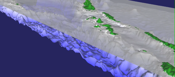
Preliminary simulation of the tsunami from the April 2007 M=8.1 earthquake in the Solomon Islands - NW
Preliminary simulation of the tsunami from the April 2007 M=8.1 earthquake in the Solomon Islands - NWPreliminary simulation of the tsunami from the April 2007 M=8.1 earthquake in the Solomon Islands. Viewpoint looks to the northwest across the Solomon Sea. The first 73 minutes of propagation is shown.
Preliminary simulation of the tsunami from the April 2007 M=8.1 earthquake in the Solomon Islands - NW
Preliminary simulation of the tsunami from the April 2007 M=8.1 earthquake in the Solomon Islands - NWPreliminary simulation of the tsunami from the April 2007 M=8.1 earthquake in the Solomon Islands. Viewpoint looks to the northwest across the Solomon Sea. The first 73 minutes of propagation is shown.

Hovering Above—UAS’ Role in the 2018 Kīlauea Volcano Eruption Response
Hovering Above—UAS’ Role in the 2018 Kīlauea Volcano Eruption ResponseThe 2018 Kīlauea Volcano eruption marked the first time the federal government used Unmanned Aircraft Systems (UAS) to assist in an eruption response in the United States.
Hovering Above—UAS’ Role in the 2018 Kīlauea Volcano Eruption Response
Hovering Above—UAS’ Role in the 2018 Kīlauea Volcano Eruption ResponseThe 2018 Kīlauea Volcano eruption marked the first time the federal government used Unmanned Aircraft Systems (UAS) to assist in an eruption response in the United States.

Hovering Above—UAS’ Role in the 2018 Kīlauea Volcano Eruption (AD)
Hovering Above—UAS’ Role in the 2018 Kīlauea Volcano Eruption (AD)The 2018 Kīlauea Volcano eruption marked the first time the federal government used Unmanned Aircraft Systems (UAS) to assist in an eruption response in the United States.
Hovering Above—UAS’ Role in the 2018 Kīlauea Volcano Eruption (AD)
Hovering Above—UAS’ Role in the 2018 Kīlauea Volcano Eruption (AD)The 2018 Kīlauea Volcano eruption marked the first time the federal government used Unmanned Aircraft Systems (UAS) to assist in an eruption response in the United States.

Shaking of Atwood Building, Mw 7.0 November 30, 2018, Anchorage quake
Shaking of Atwood Building, Mw 7.0 November 30, 2018, Anchorage quakeThis video presents a visualization of how the Atwood Building in Anchorage, Alaska, shook during the Mw 7.0 November 30, 2018, Anchorage, Alaska, earthquake. The building was instrumented by the U.S. Geological Survey to obtain data to study its behavior and performance during strong shaking.
Shaking of Atwood Building, Mw 7.0 November 30, 2018, Anchorage quake
Shaking of Atwood Building, Mw 7.0 November 30, 2018, Anchorage quakeThis video presents a visualization of how the Atwood Building in Anchorage, Alaska, shook during the Mw 7.0 November 30, 2018, Anchorage, Alaska, earthquake. The building was instrumented by the U.S. Geological Survey to obtain data to study its behavior and performance during strong shaking.

Shaking of Frontier Building, M7.0 November 30, 2018, Anchorage Quake
Shaking of Frontier Building, M7.0 November 30, 2018, Anchorage QuakeThis video presents a visualization of how the Frontier Building in Anchorage, Alaska, shook during the moment magnitude (Mw) 7.0 November 30, 2018, Anchorage, Alaska, earthquake. The building was instrumented by U.S. Geological Survey to obtain data to study its behavior and performance during strong shaking.
Shaking of Frontier Building, M7.0 November 30, 2018, Anchorage Quake
Shaking of Frontier Building, M7.0 November 30, 2018, Anchorage QuakeThis video presents a visualization of how the Frontier Building in Anchorage, Alaska, shook during the moment magnitude (Mw) 7.0 November 30, 2018, Anchorage, Alaska, earthquake. The building was instrumented by U.S. Geological Survey to obtain data to study its behavior and performance during strong shaking.

Shaking of BP Exploration Building, M7 Nov. 30, 2018, Anchorage Quake
Shaking of BP Exploration Building, M7 Nov. 30, 2018, Anchorage QuakeThis video presents a visualization of how the BP Exploration Building in Anchorage, Alaska, shook during the moment magnitude (Mw) 7.0 November 30, 2018, Anchorage, Alaska, earthquake. The building was instrumented by U.S. Geological Survey (USGS) to obtain data to study its behavior and performance during strong shaking.
Shaking of BP Exploration Building, M7 Nov. 30, 2018, Anchorage Quake
Shaking of BP Exploration Building, M7 Nov. 30, 2018, Anchorage QuakeThis video presents a visualization of how the BP Exploration Building in Anchorage, Alaska, shook during the moment magnitude (Mw) 7.0 November 30, 2018, Anchorage, Alaska, earthquake. The building was instrumented by U.S. Geological Survey (USGS) to obtain data to study its behavior and performance during strong shaking.

PubTalk 10/2018 — Post-fire debris flow early warning
PubTalk 10/2018 — Post-fire debris flow early warningTitle: Post-Fire Debris-Flow Early Warning: The case for forecast-based warning systems
PubTalk 10/2018 — Post-fire debris flow early warning
PubTalk 10/2018 — Post-fire debris flow early warningTitle: Post-Fire Debris-Flow Early Warning: The case for forecast-based warning systems

PubTalk 9/2018 - Hayward Earthquake
Title: The 150th Anniversary of the Damaging 1868 Hayward Earthquake: Why It Matters and How We Can Prepare for Its Repeat
Title: The 150th Anniversary of the Damaging 1868 Hayward Earthquake: Why It Matters and How We Can Prepare for Its Repeat

First mission: USGS UAS monitors gas emissions at Mount St. Helens
First mission: USGS UAS monitors gas emissions at Mount St. HelensOn September 25, 2018, a team of three scientists based at the USGS–Cascades Volcano Observatory conducted the first-ever USGS-led Unmanned Aircraft Systems (UAS) campaign at Mount St. Helens. The UAS survey was conducted with the permission and coordination of the U.S. Forest Service Mount St. Helens National Volcanic Monument.
First mission: USGS UAS monitors gas emissions at Mount St. Helens
First mission: USGS UAS monitors gas emissions at Mount St. HelensOn September 25, 2018, a team of three scientists based at the USGS–Cascades Volcano Observatory conducted the first-ever USGS-led Unmanned Aircraft Systems (UAS) campaign at Mount St. Helens. The UAS survey was conducted with the permission and coordination of the U.S. Forest Service Mount St. Helens National Volcanic Monument.

First mission: USGS UAS monitors gas emissions at Mount St. Helens —AD
First mission: USGS UAS monitors gas emissions at Mount St. Helens —ADOn September 25, 2018, a team of three scientists based at the USGS–Cascades Volcano Observatory conducted the first-ever USGS-led Unmanned Aircraft Systems (UAS) campaign at Mount St. Helens. The UAS survey was conducted with the permission and coordination of the U.S. Forest Service Mount St. Helens National Volcanic Monument.
First mission: USGS UAS monitors gas emissions at Mount St. Helens —AD
First mission: USGS UAS monitors gas emissions at Mount St. Helens —ADOn September 25, 2018, a team of three scientists based at the USGS–Cascades Volcano Observatory conducted the first-ever USGS-led Unmanned Aircraft Systems (UAS) campaign at Mount St. Helens. The UAS survey was conducted with the permission and coordination of the U.S. Forest Service Mount St. Helens National Volcanic Monument.

Northwest ShakeAlert Sensor Station
Maintenance of a high-quality ShakeAlert sensors, power and telemetry stations.
Maintenance of a high-quality ShakeAlert sensors, power and telemetry stations.

B-Roll California ShakeAlert Sensor
Maintenance of high quality ShakeAlert sensor, power and telemetry station.
Maintenance of high quality ShakeAlert sensor, power and telemetry station.

PubTalk 8/2018 — What on Earth is going on at Kilauea Volcano?
PubTalk 8/2018 — What on Earth is going on at Kilauea Volcano?Title: What on Earth is going on at Kilauea Volcano?
- First significant summit explosions in nearly a century
- Largest summit collapse volume since at least 1800
- Voluminous fissure eruptions feeding channelized lava flow
- Unparalleled new opportunities for understanding the volcanic system
PubTalk 8/2018 — What on Earth is going on at Kilauea Volcano?
PubTalk 8/2018 — What on Earth is going on at Kilauea Volcano?Title: What on Earth is going on at Kilauea Volcano?
- First significant summit explosions in nearly a century
- Largest summit collapse volume since at least 1800
- Voluminous fissure eruptions feeding channelized lava flow
- Unparalleled new opportunities for understanding the volcanic system

Image of the Week - Mendocino Fire
Landsat 8 captured satellite views of California’s largest wildfire on record in the summer of 2018. The Mendocino Complex Fire in northern California is a combination of two fires: the Ranch Fire and the River Fire.
Landsat 8 captured satellite views of California’s largest wildfire on record in the summer of 2018. The Mendocino Complex Fire in northern California is a combination of two fires: the Ranch Fire and the River Fire.

Kīlauea Volcano — Lava Oozing

Kīlauea Volcano — Timelapse Changes at Caldera (6/13 - 7/7)
Kīlauea Volcano — Timelapse Changes at Caldera (6/13 - 7/7)This series of images from June 13 through July 7, 2018, show dramatic down-dropping of part of Kīlauea Volcano's summit caldera floor. For weeks, the summit has subsided in both a continuous fashion, as well as in incremental, jolting drops.
Kīlauea Volcano — Timelapse Changes at Caldera (6/13 - 7/7)
Kīlauea Volcano — Timelapse Changes at Caldera (6/13 - 7/7)This series of images from June 13 through July 7, 2018, show dramatic down-dropping of part of Kīlauea Volcano's summit caldera floor. For weeks, the summit has subsided in both a continuous fashion, as well as in incremental, jolting drops.

Kīlauea Volcano — Whirlwind Above Fissure 8
In the Leilani Estates subdivision, Hawaiian Volcano Observatory field crews monitoring fissure 8 captured this video of a whirlwind above the lava channel.
In the Leilani Estates subdivision, Hawaiian Volcano Observatory field crews monitoring fissure 8 captured this video of a whirlwind above the lava channel.