Water Quality of San Francisco Bay Jim Cloern With R/V Polaris
Water Quality of San Francisco Bay Jim Cloern With R/V PolarisUSGS scientist Jim Cloern with the R/V Polaris, 1980s.

Official websites use .gov
A .gov website belongs to an official government organization in the United States.
Secure .gov websites use HTTPS
A lock () or https:// means you’ve safely connected to the .gov website. Share sensitive information only on official, secure websites.
Explore water-related photography, imagery, and illustrations.

USGS scientist Jim Cloern with the R/V Polaris, 1980s.
USGS scientist Jim Cloern with the R/V Polaris, 1980s.

Approximate point of maximum subsidence in the San Joaquin Valley, California. Land surface subsided ~9 m from 1925 to 1977 due to aquifer-system compaction. Signs on the telephone pole indicate the former elevations of the land surface in 1925 and 1955.
Photograph by Richard Ireland, U.S. Geological Survey

U.S. Geological Survey streamflow-gaging station 08116650 Brazos River near Rosharon, Texas, looking upstream from Farm-to-Market Road (FM) 1462 bridge, August 28, 1973.
USGS SIR 2009–5174
U.S. Geological Survey streamflow-gaging station 08116650 Brazos River near Rosharon, Texas, looking upstream from Farm-to-Market Road (FM) 1462 bridge, August 28, 1973.
USGS SIR 2009–5174

Map shows floods in the Aguadilla-Aguada area, northwestern Puerto Rico. The image is from USGS Hydrologic Atlas 457, created in 1972.
Map shows floods in the Aguadilla-Aguada area, northwestern Puerto Rico. The image is from USGS Hydrologic Atlas 457, created in 1972.

U.S. Geological Survey streamflow-gaging station 08109000 Brazos River near Bryan, Texas, looking upstream from left bank, March 10, 1971.
USGS SIR 2009–5174
U.S. Geological Survey streamflow-gaging station 08109000 Brazos River near Bryan, Texas, looking upstream from left bank, March 10, 1971.
USGS SIR 2009–5174

U.S. Geological Survey streamflow-gaging station 08116650 Brazos River near Rosharon, Texas, (A) looking upstream from right bank, April 2, 1967 (not known if pilings visible at base of bridge pier are result of channel-bed incision).
USGS SIR 2009–5174
U.S. Geological Survey streamflow-gaging station 08116650 Brazos River near Rosharon, Texas, (A) looking upstream from right bank, April 2, 1967 (not known if pilings visible at base of bridge pier are result of channel-bed incision).
USGS SIR 2009–5174

U.S. Geological Survey streamflow-gaging station 08098290 Brazos River near Highbank, Texas, looking downstream from FM 413 bridge, March 31, 1964.
SIR 2009–5174
U.S. Geological Survey streamflow-gaging station 08098290 Brazos River near Highbank, Texas, looking downstream from FM 413 bridge, March 31, 1964.
SIR 2009–5174

U.S. Geological Survey streamflow-gaging station 08098290 Brazos River near Highbank, Texas, looking upstream from FM 413 bridge, March 31, 1964.
SIR 2009–5174
U.S. Geological Survey streamflow-gaging station 08098290 Brazos River near Highbank, Texas, looking upstream from FM 413 bridge, March 31, 1964.
SIR 2009–5174

Although large streamgage structures are no longer necessary, the USGS still uses some of them to contain modern streamgage equipment.
Although large streamgage structures are no longer necessary, the USGS still uses some of them to contain modern streamgage equipment.

Artesian well investigations in South Dakota (circa-July 1957).
Artesian well investigations in South Dakota (circa-July 1957).

Artesian well investigations in South Dakota (circa 1956-62).
Artesian well investigations in South Dakota (circa 1956-62).

U.S. Geological Survey streamflow-gaging station 08109000 Brazos River near Bryan, Texas, looking upstream from left bank, February 5, 1954.
SIR 2009–5174
U.S. Geological Survey streamflow-gaging station 08109000 Brazos River near Bryan, Texas, looking upstream from left bank, February 5, 1954.
SIR 2009–5174

U.S. Geological Survey streamflow-gaging station 08110500 Navasota River near Easterly, Texas, looking downstream from left bank, December 5, 1941.
SIR 2009–5174
U.S. Geological Survey streamflow-gaging station 08110500 Navasota River near Easterly, Texas, looking downstream from left bank, December 5, 1941.
SIR 2009–5174

U.S. Geological Survey streamflow-gaging station 08110500 Navasota River near Easterly, Texas, looking upstream, June 7, 1934.
SIR 2009–5174
U.S. Geological Survey streamflow-gaging station 08110500 Navasota River near Easterly, Texas, looking upstream, June 7, 1934.
SIR 2009–5174

September 21, 1923, 9:00 a.m. --- Colorado River at Lees Ferry. From right bank on line with Klohr's house and gage house. Old "Dugway" or inclined gage shows to left of gage house. Gage height 11.05', discharge 27,000 cfs. Lens 16, time =1/25, camera supported. Photo by G.C. Stevens of the USGS. Source: 1921-1937 Surface Water Records File, Colorado R.
September 21, 1923, 9:00 a.m. --- Colorado River at Lees Ferry. From right bank on line with Klohr's house and gage house. Old "Dugway" or inclined gage shows to left of gage house. Gage height 11.05', discharge 27,000 cfs. Lens 16, time =1/25, camera supported. Photo by G.C. Stevens of the USGS. Source: 1921-1937 Surface Water Records File, Colorado R.
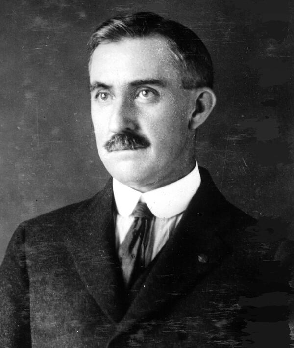
Oscar Edward Meinzer, First Chief, Groundwater Resources. He was an early or first scientist to recognize the elasticity of soils, and artesian wells, and its importance, to measuring water resources. circa 1916.
Oscar Edward Meinzer, First Chief, Groundwater Resources. He was an early or first scientist to recognize the elasticity of soils, and artesian wells, and its importance, to measuring water resources. circa 1916.

Hydrographer taking a cableway streamflow measurement at the first USGS streamgage at Embudo, New Mexico, established in 1889.
Hydrographer taking a cableway streamflow measurement at the first USGS streamgage at Embudo, New Mexico, established in 1889.

Embudo Student Hydrographers

USGS prersonnel at the Embudo Station, New Mexico. Embudo was selected as the site of the first USGS streamgaging station in 1889 because of the need for systematic water resource assessments of western states as it not only offered a favorable climate and easy rail access, but qualified for congressional funding tapped specifically for the “arid West.”
USGS prersonnel at the Embudo Station, New Mexico. Embudo was selected as the site of the first USGS streamgaging station in 1889 because of the need for systematic water resource assessments of western states as it not only offered a favorable climate and easy rail access, but qualified for congressional funding tapped specifically for the “arid West.”

USGS staff checking the streamgage equipment on the San Saba River in Texas.
USGS staff checking the streamgage equipment on the San Saba River in Texas.

A hydrologic technician from the USGS Idaho Water Science Center measures streamflow in the St. Joe River at Red Ives Ranger Station in northern Idaho. The USGS is collecting data at hundreds of sites on rivers and streams in six western states to document the 2015 drought.
A hydrologic technician from the USGS Idaho Water Science Center measures streamflow in the St. Joe River at Red Ives Ranger Station in northern Idaho. The USGS is collecting data at hundreds of sites on rivers and streams in six western states to document the 2015 drought.