
Dan Edwards and Gary Wall attach a hydroacoustic and turbidity equipment package to a tripod for deployment on the bottom of the Hudson River near Poughkeepsie, NY
Images
Explore water-related photography, imagery, and illustrations.
Filter Total Items: 2584

NYWSC_HydroacousticTurbidity
Dan Edwards and Gary Wall attach a hydroacoustic and turbidity equipment package to a tripod for deployment on the bottom of the Hudson River near Poughkeepsie, NY

Medina River Winter View at Bandera, TX
Clear cool water over a limestone rock and gravel riverbed is characteristic of many Texas Hill County Creeks and Rivers.
Clear cool water over a limestone rock and gravel riverbed is characteristic of many Texas Hill County Creeks and Rivers.

USGS regional research drill rig near Truckee River, NV
USGS regional research drill rig near Truckee River, NVUSGS regional research drill rig constructing sites near the south bank of the Truckee River just downstream of USGS 10350000 Truckee River at Vista. The wells were constructed to investigate surface water groundwater interaction.

Batavia Kill at Red Falls, Greene County, NY
Batavia Kill at Red Falls, Greene County, NY

Water sampling in tidal marsh on Long Island
USGS scientists taking water samples in the tidal marsh on Long Island.
USGS scientists taking water samples in the tidal marsh on Long Island.
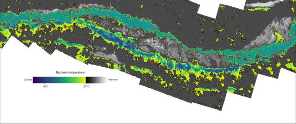
Thermal infrared mosaic of Quartzville Creek, OR
Thermal infrared mosaic of Quartzville Creek, OR. These images were captured on the year 2000 as part of an airborne thermal infrared survey conducted in the Santiam River basin, OR. The images were orthorectified and mosaicked into a single raster in order to identify and visualize thermal heterogeneity.
Thermal infrared mosaic of Quartzville Creek, OR. These images were captured on the year 2000 as part of an airborne thermal infrared survey conducted in the Santiam River basin, OR. The images were orthorectified and mosaicked into a single raster in order to identify and visualize thermal heterogeneity.


Domestic (private) well
More than 40 million people in the U.S. rely on domestic wells, like the one shown here, for their drinking water. Concentrations of groundwater at the wellhead typically are low, but lead can leach into the water from corrosion of household plumbing that contains lead.
More than 40 million people in the U.S. rely on domestic wells, like the one shown here, for their drinking water. Concentrations of groundwater at the wellhead typically are low, but lead can leach into the water from corrosion of household plumbing that contains lead.

Long Island core samples
Long Island core samples

Groundwater Sampling on Long Island
Groundwater sampling for water quality on Long Island, New York
Groundwater sampling for water quality on Long Island, New York

Oklahoma Groundwater Efforts
USGS Student Jessica Magers examining outcrop of the Rush Springs aquifer in Caddo County, Oklahoma for arsenic and other metals concentration.
USGS Student Jessica Magers examining outcrop of the Rush Springs aquifer in Caddo County, Oklahoma for arsenic and other metals concentration.

Coastal Salt Marsh
An Everglades National Park coastal salt marsh crossed with drainage creeks.
An Everglades National Park coastal salt marsh crossed with drainage creeks.

Station 08028500 Sabine River near Bon Wier, Texas
Station 08028500 Sabine River near Bon Wier, TexasU.S. Geological Survey streamflow-gaging station 08028500 Sabine River near Bon Wier, Texas, photograph looking from left bank adjacent to U.S. Highway 190 bridge, May 30, 1999.
SIR 2009–5174
Station 08028500 Sabine River near Bon Wier, Texas
Station 08028500 Sabine River near Bon Wier, TexasU.S. Geological Survey streamflow-gaging station 08028500 Sabine River near Bon Wier, Texas, photograph looking from left bank adjacent to U.S. Highway 190 bridge, May 30, 1999.
SIR 2009–5174

Coastal Dune with Seaoats (Uniola paniculata) and Spanish Bayonets (Yucca Sp.)
Coastal Dune with Seaoats (Uniola paniculata) and Spanish Bayonets (Yucca Sp.)Florida's Atlantic coastal dune with typical vegetation such as seaoats and Spanish bayonets. Trails to the beach cut through the dune. Photograph taken circa 1998.

1997 Flooding in Grand Forks
Burned-out buildings in downtown Grand Forks, North Dakota.
Burned-out buildings in downtown Grand Forks, North Dakota.

1997 Flooding in Grand Forks
Flooding of homes in Grand Forks, North Dakota in 1997.
Flooding of homes in Grand Forks, North Dakota in 1997.

1997 Flooding in Grand Forks
An inundated building in Grand Forks, North Dakota durring the Red River of the North Flood.
An inundated building in Grand Forks, North Dakota durring the Red River of the North Flood.

1997 Flooding in Grand Forks
Boats on city streets of Grand Forks, North Dakota and East Grand Forks, Minnesota during the 1997 Red River of the North flood.
Boats on city streets of Grand Forks, North Dakota and East Grand Forks, Minnesota during the 1997 Red River of the North flood.

Flooding in Grand Forks, North Dakota in 1997
Downtown Grand Forks, North Dakota flooded by the Red River of the North in 1997.
Downtown Grand Forks, North Dakota flooded by the Red River of the North in 1997.

1997 Flooding in Grand Forks
Grand Forks flooding on Highway 2.
Grand Forks flooding on Highway 2.

Flooding of the Sorlie Bridge
The Sorlie Bridge between Grand Forks, North Dakota and East Grand Forks, Minnesota, during the 1997 Red River of the North flood.
The Sorlie Bridge between Grand Forks, North Dakota and East Grand Forks, Minnesota, during the 1997 Red River of the North flood.