



Industry and Mining
Industry and Mining
Filter Total Items: 34

Water Use in the United States
Since 1950, the USGS has regularly produced nationwide water‑use data, creating one of the most comprehensive pictures of how water is used across the United States. Building on this rich historical record, these data give water managers a critical foundation to evaluate long‑term trends, plan strategically, and identify and quantify water availability so they can design more adaptive, resilient...

National Water Monitoring Network
To manage our water resources effectively, we need to understand how much water is available and its usefulness. The USGS monitors the nation’s water resources through various national observing networks that use a range of technologies and methods to assess real-time water conditions and predict future changes in water availability for human and ecological uses.

National Water Availability Assessments
The USGS National Water Availability Assessment consists of reports, which provide a scientific summary and interpretation of water quantity, quality and use, and the data companion, which delivers model-based estimates of water supply and demand.

Integrated Water Availability Assessments
The USGS Water Resources Mission Area is assessing how much water is available for human and ecological needs in the United States and identifying where and when the Nation may have challenges meeting its demand for water.

Integrated Water Availability Assessments Fundamentals
The USGS Water Resources Mission Area is assessing how much water is available for human and ecological needs in the United States and identifying where and when the Nation may have challenges meeting its demand for water.

Regional Water Availability Assessment: Upper Colorado River Basin
Regional Water Availability Assessments are scientific assessments of water availability in different hydrologic regions across the Nation. In the Upper Colorado River Basin, the USGS will conduct a focused assessment of how snowpack and snowmelt influence hydrology and water quality, and an integrated and comprehensive assessment of multiple water quantity, quality and use factors.

Understanding Water Availability
The United States faces growing challenges to its water supply, and we need to know where there is not enough water, where we have more than we need, and the quality of the water. The USGS is charged with understanding and reporting on water availability including influences on water supply (how much water and of what quality) and water demand (how much water do humans and ecosystems need).

Water-Use Data and Research (WUDR) program
The USGS Water-Use Data and Research (WUDR) program provides financial assistance through cooperative agreements with State water resource agencies to improve the availability, quality, compatibility, and delivery of water-use data that is collected or estimated by States.

Integrated Water Science (IWS) Basins
The U.S. Geological Survey is integrating its water science programs to better address the Nation’s greatest water resource challenges. At the heart of this effort are plans to intensively study several Integrated Water Science (IWS) basins—medium-sized watersheds (10,000-20,000 square miles) and underlying aquifers—over the next decade. The IWS basins will represent a wide range of environmental...
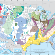
Principal Aquifers of the United States
This website compiles USGS resources and data related to principal aquifers including Aquifer Basics, principal aquifers maps and GIS data, and the National Aquifer Code Reference List.

Transboundary Assessments of Water Quality in the Pacific Northwest
In 2019, the USGS began studying the baseline water-quality of selected transboundary rivers in the Pacific Northwest. These studies are designed to characterize current water-quality conditions so as to facilitate future assessments of potential impacts related to upstream mining activities.

Atmospheric Warming, Loss of Snow Cover, and Declining Colorado River Flow
Declining snow cover is playing a key role in decreasing the flow of the Colorado River, “the lifeblood of the Southwest,” by enabling increased evaporation. As the warming continues, increasingly severe water shortages are expected.