

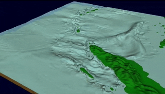
On December 26th, 2004, a massive 9.1 magnitude earthquake struck off the west coast of northern Sumatra, Indonesia. The third largest earthquake ever recorded lifted the sea floor several meters, causing tsunami waves to ripple out in all directions and race across the ocean. Banda Aceh bore the brunt of the waves just 15 to 20 minutes after the earthquake.
The Night the Earth Shook
USGS's Response to the 2004 Sumatra Earthquake
USGS's Response to the 2004 Sumatra Earthquake
By Communications and Publishing
December 19, 2024
In late December 2004, one of the world’s most powerful earthquakes ever struck near Sumatra. This is the story of how USGS responded to the event as told by those who experienced it.
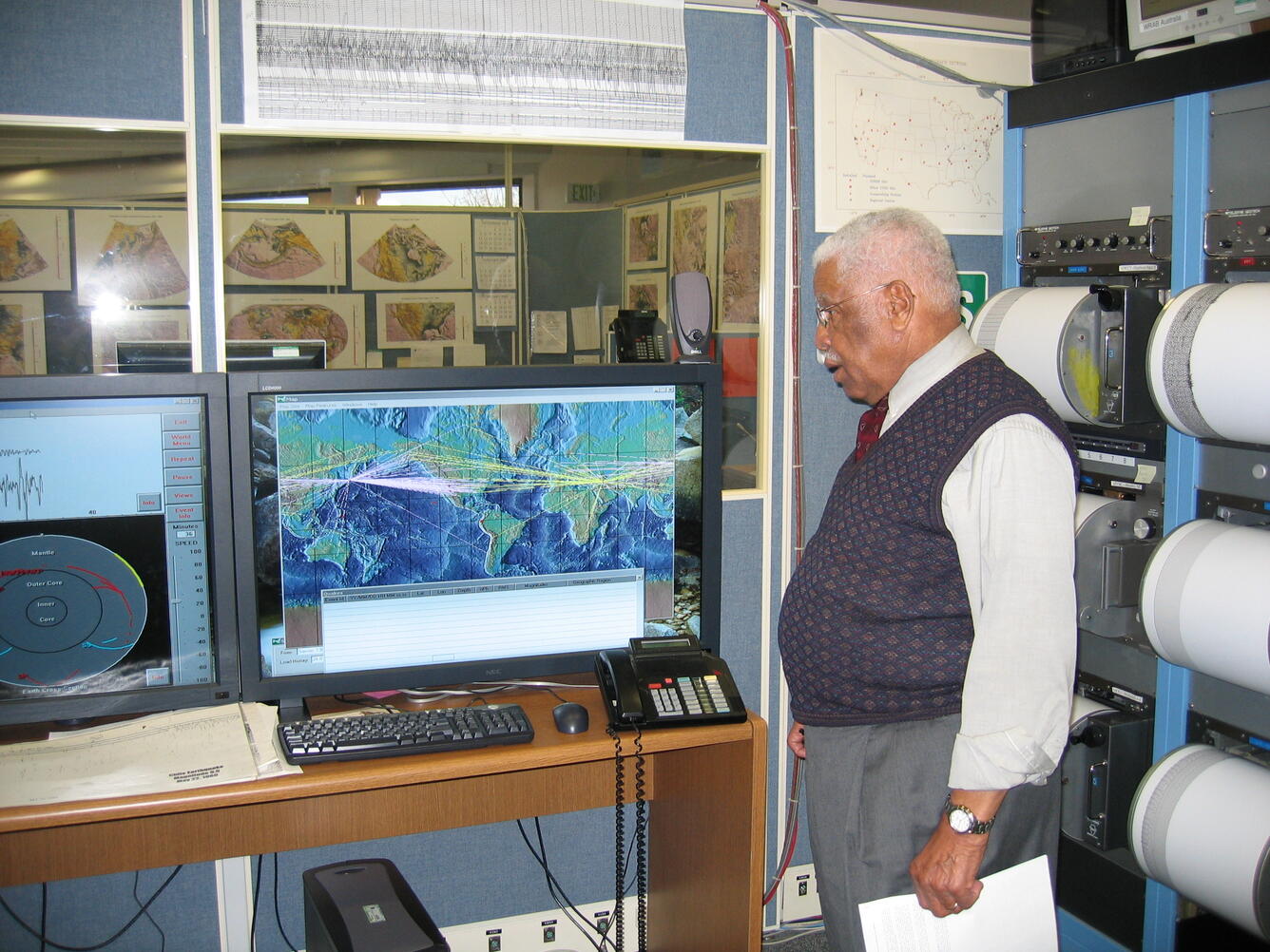
It was 5:58 p.m. on Christmas Day 2004 in Golden, Colorado, when the first seismic waves arrived from halfway around the world. A massive magnitude 9.1 earthquake that had just struck off the coast of Sumatra at 7:58 a.m. local time sent vibrations racing through the Earth's crust at several kilometers per second, eventually reaching the sensors that track global seismicity at the USGS National Earthquake Information Center.
Inside the building nestled in the foothills of the Rocky Mountains, the skeleton crew working the holiday shift noticed something dramatic. Their computer screens were lighting up with incoming data from seismic stations across the globe. What first appeared as subtle squiggles quickly grew into dramatic spikes as the primary waves arrived, followed by even larger secondary waves.
Massive Earthquake
Massive Earthquake
Dr. Stuart Sipkin, the research scientist on duty, knew immediately this was no ordinary earthquake. The initial readings were literally off the charts; the instruments were saturated by the sheer scale of the seismic waves. As more data poured in from hundreds of seismic stations worldwide, it became clear they were dealing with something unprecedented in modern instrumented history.
Within an hour, despite it being Christmas Day, a team of seismologists had assembled in the center's main operations room. The rounded helicorders or drum recorders zig-zagged displaying real-time seismic data from around the world. The room hummed with focused energy as scientists hunched over keyboards, analyzing the incoming flood of information.
Fault Rupture
Fault Rupture
The team, led by Benz and Sipkin, worked methodically through their protocols, but everything about this earthquake was challenging their normal procedures. The initial magnitude estimates kept climbing as more data arrived. Traditional methods weren't adequate for an event of this size, pushing the team to implement newly developed techniques for measuring massive earthquakes in real-time. They would later determine that the fault had ruptured a length of nearly 1,500 kilometers/930 miles.
Media
Sources/Usage: Public Domain. View Media Details
The most haunting moment came when they realized the danger for the Indian Ocean region. Their scientific training told them that an earthquake this large, in that location, would have displaced an enormous amount of water. Tsunami waves were likely already racing across the ocean at jet-plane speeds.
The team knew that every minute counted. They began reaching out to their international contacts and tsunami warning centers, though at the time there was no comprehensive warning system in the Indian Ocean that could disseminate warnings to the public.
As the scientists worked through the night, reports began trickling in from the region. The first news of devastating tsunami waves hitting coastlines confirmed their worst fears. The earthquake they had measured from their computers in Colorado was unleashing one of the deadliest disasters in recorded history.
The scope of loss became incomprehensible. Entire communities vanished. Villages that had stood for centuries disappeared. The tsunami claimed more lives in a few hours than any other natural disaster of the 21st century.
- Indonesia: Over 167,000 fatalities
- Sri Lanka: More than 35,000 fatalities
- India: Around 18,000 fatalities
- Thailand: Over 8,000 fatalities
And thousands more across other affected nations.
With phones ringing constantly and reporters requesting live interviews around the world, the team was filing in and out of the NEIC, obtaining the latest known scientific details and grabbing sticky notes with interview requests from the window of the “war room.”
Sources/Usage: Public Domain. View Media Details

Clinging to a Tree
Clinging to a Tree
Bruce Presgrave, then supervisor of the NEIC seismic analysts whose primary job was to pore through data and locate earthquakes around the globe daily, was responding to news media about the enormous earthquake when a Denver-based father called panicking; he was on the other line with his daughter who was visiting Phuket, Thailand, for the holiday. And she was clinging to a tree witnessing the waves rapidly approaching.
Presgrave, now a USGS emeritus scientist, promptly took the call into his office and instructed the father to tell her to stay in the tree until the wave passed, then provided additional direction about what she should do in the aftermath.
This was the first magnitude 9 or larger earthquake in 40 years. An entire generation of seismologists had not yet seen such a large event. This earthquake was a pivotal moment for USGS earthquake monitoring.
Although the USGS had started to develop modern methods to characterize the size of the largest earthquakes, this one tested these new systems and methods. McCarthy and Benz had drafted white papers to address the missing pieces of technology, notably a new seismic event processing system, which would be called HYDRA, and additional staffing to reduce the time of reporting information about global earthquakes.
And this event was the trigger to make these changes a reality.
The team's response to this event catalyzed significant changes in earthquake monitoring. Their work proved crucial in several ways:
- Development of enhanced methods for rapidly calculating accurate magnitudes for major earthquakes
- Implementation of improved data sharing protocols with international partners
- Creation of new systems for coordinating with tsunami warning centers
- Establishment of 24/7 monitoring operations at the NEIC


Sources/Usage: Public Domain. View Media Details
The transition to round-the-clock staffing was announced shortly after the event, marking a significant evolution in the USGS's earthquake monitoring capabilities. This new operational structure ensured that even during holidays and off-hours, a full team would be ready to respond to major seismic events.
Enhancements were made possible by the Fiscal Year 2005 \$8.1 million Emergency Supplemental Appropriation and a \$5.4 million request in the FY 2006 President's Budget approved the previous year by Congress.
The experience left an indelible mark on everyone involved. They had been among the first people on Earth to comprehend the scale of what was unfolding, watching data from the instruments as seismic waves rippled through the planet's interior, bringing urgent messages of the disaster that was just beginning half a world away.
Within a few years, NEIC was able to rapidly and accurately report on 15 or more Magnitude 8 or larger earthquakes since, including the magnitude 9 Tohoku, Japan earthquake and tsunami.
From the 2011 Seismological Research Letters publication 88 hours: The U.S. Geological Survey National Earthquake Information Center response to the March 11, 2011, Mw 9.0 Tohoku earthquake:
“It is illuminating to compare NEIC responses to the 2011 Tohoku and the great Mw 9.1 26 December 2004 SumatraAndaman Islands earthquakes. In the latter case, the initial automatic NEIC solution (not a public release) came after 17 minutes, with an mb of 6.2. After 10 more minutes, an automatic CMT solution gave the first internal indication of the large size of the earthquake, with a moment magnitude of Mw 8.2. One hour and 23 minutes after OT, parameters were publicly released using an Ms magnitude of 8.5. The magnitude was later updated to Mw 8.9 after six hours and 13 minutes, based on the preliminary global CMT (at that time, Harvard CMT) solution. Importantly, at that time NEIC was dependent on others to provide an authoritative measure of earthquake size.”
National Earthquake Information Center
National Earthquake Information Center
Twenty years later, Benz, McCarthy and Earle recall the profound sense of responsibility they felt, knowing they were witnessing something historic in the instrument data while being powerless to prevent the immense tragedy that would follow.
Their experience underscored both the awesome power of nature and the critical importance of their scientific monitoring work in Golden, serving as Earth's watchkeepers from their post in the Colorado foothills.
Related

Image of the Week - 2004 Indian Ocean Tsunami
On December 26th, 2004, a massive 9.1 magnitude earthquake struck off the west coast of northern Sumatra, Indonesia. The third largest earthquake ever recorded lifted the sea floor several meters, causing tsunami waves to ripple out in all directions and race across the ocean. Banda Aceh bore the brunt of the waves just 15 to 20 minutes after the earthquake.

PubTalk 12/2014 — Ten Years After the 2004 Indian Ocean Tsunami
PubTalk 12/2014 — Ten Years After the 2004 Indian Ocean TsunamiHow geology is reducing tsunami risk
by Bruce Jaffe, USGS Research Oceanographer
PubTalk 12/2014 — Ten Years After the 2004 Indian Ocean Tsunami
PubTalk 12/2014 — Ten Years After the 2004 Indian Ocean TsunamiHow geology is reducing tsunami risk
by Bruce Jaffe, USGS Research Oceanographer
Related
Image of the Week - 2004 Indian Ocean Tsunami
On December 26th, 2004, a massive 9.1 magnitude earthquake struck off the west coast of northern Sumatra, Indonesia. The third largest earthquake ever recorded lifted the sea floor several meters, causing tsunami waves to ripple out in all directions and race across the ocean. Banda Aceh bore the brunt of the waves just 15 to 20 minutes after the earthquake.
On December 26th, 2004, a massive 9.1 magnitude earthquake struck off the west coast of northern Sumatra, Indonesia. The third largest earthquake ever recorded lifted the sea floor several meters, causing tsunami waves to ripple out in all directions and race across the ocean. Banda Aceh bore the brunt of the waves just 15 to 20 minutes after the earthquake.
PubTalk 12/2014 — Ten Years After the 2004 Indian Ocean Tsunami
PubTalk 12/2014 — Ten Years After the 2004 Indian Ocean TsunamiHow geology is reducing tsunami risk
by Bruce Jaffe, USGS Research Oceanographer
PubTalk 12/2014 — Ten Years After the 2004 Indian Ocean Tsunami
PubTalk 12/2014 — Ten Years After the 2004 Indian Ocean TsunamiHow geology is reducing tsunami risk
by Bruce Jaffe, USGS Research Oceanographer