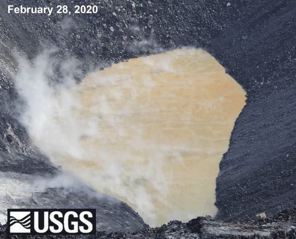
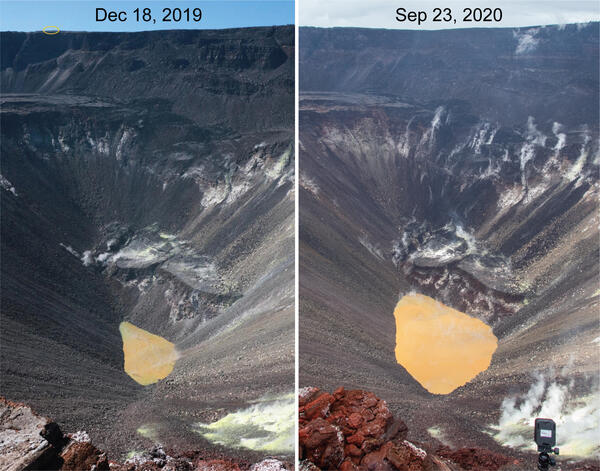
The spatter cone at fissure 8 is now about 55 m (180 ft) tall. Lava fountains rise only occasionally above that point, sending a shower of
Images
Hawaiian Volcano Observatory images of eruptive activity, field work, and more.
The spatter cone at fissure 8 is now about 55 m (180 ft) tall. Lava fountains rise only occasionally above that point, sending a shower of
Kīlauea Volcano — Animated GIF of Crater Subsidence
Kīlauea Volcano — Animated GIF of Crater SubsidenceThis animated GIF shows a timelapse sequence consisting of one image per day between June 13 and 24. The photos were taken from the southern caldera rim, near Keanakāko‘i Crater, and look north towards HVO and Jaggar Museum.
View to the southwest, looking "up" the lava channel. Lava flows from Fissure 8 (not pictured) through the open channel about 13 km (8 mi) to the ocean. Lava remains incandescent (glowing orange) along the entire length of the channel with sections of cooled lava (black) on the surface.
At fissure 8, fountains provide a vigorous supply of lava that exits the cinder cone and drops over a spillway to enter a well-established lava channel that extends to the sea.
Kīlauea Volcano — Small Halema`uma`u Eruption (June 24, 2018)
Kīlauea Volcano — Small Halema`uma`u Eruption (June 24, 2018)On June 24 a small ash-poor steam plume rose above the Halema‘uma‘u crater rim following another collapse explosion event at 4:12 p.m. HST (image taken at 4:27 p.m.).
Kīlauea Volcano — Small Halema`uma`u Eruption (June 24, 2018)
Kīlauea Volcano — Small Halema`uma`u Eruption (June 24, 2018)On June 24 a small ash-poor steam plume rose above the Halema‘uma‘u crater rim following another collapse explosion event at 4:12 p.m. HST (image taken at 4:27 p.m.).
Kīlauea summit subsides and produces frequent earthquakes
Kīlauea summit subsides and produces frequent earthquakesOn June 23, 2018 at 4:32 p.m. HST after approximately 17 hours of elevated seismicity, a collapse explosion occurred at the summit if Kīlauea. The energy released by the event was equivalent to a magnitude 5.3 earthquake.
Kīlauea Volcano — Halema`uma`u Crater Collapse (June 23, 2018)
Kīlauea Volcano — Halema`uma`u Crater Collapse (June 23, 2018)On June 23, 2018 at 4:32 p.m. HST after approximately 17 hours of elevated seismicity, a collapse explosion occurred at the summit if Kīlauea. The energy released by the event was equivalent to a magnitude 5.3 earthquake.
Kīlauea fissure 8 lava channel transports "lava boats"
Kīlauea fissure 8 lava channel transports "lava boats"Geologists captured this time-lapse video of the perched lava channel issuing from fissure 8 on Kīlauea's lower East Rift Zone.
Kīlauea fissure 8 lava channel transports "lava boats"
Kīlauea fissure 8 lava channel transports "lava boats"Geologists captured this time-lapse video of the perched lava channel issuing from fissure 8 on Kīlauea's lower East Rift Zone.
Early morning view of the open lava channelbeginning about 5 km (3.1 miles) from Fissure 8.
Halema'uma'u crater at 8:30 a.m., view is toward the south. Several benches are clearly visible within the crater.
View of cinder cones in the Northeast Rift Zone near the summit of Mauna Loa. View to the north-northeast with Mauna Kea in the background. Mauna Loa has erupted 33 times since 1843, most recently erupting in 1975 and 1984. Photo credit: Matt Patrick, USGS
Kīlauea Volcano — Halema‘uma‘u Crater Continues Enlarging
Kīlauea Volcano — Halema‘uma‘u Crater Continues EnlargingThe USGS UAS (unoccupied aircraft system) team took this photograph of Halema‘uma‘u Crater from the Kīlauea Overlook on this morning. They are preparing for a flight to map further subsidence at the summit.
Early morning view of the ocean entry. The lava fountain from fissure 8 is visible behind the laze plume rising from the entry point. The open lava flowchannel is visible just beyond the solidified darker flows in the foreground.
Lava from fissure 8 travels about 13 km (8 mi) to the ocean in an open channel. Lava remains incandescent (glowing orange) throughout its journey. The ocean entry is at upper right.
Small streams of lava enter the ocean across a broad area, shown by the multiple white steam and laze plumes. Lava has added about 380 acres of new land into the sea.
Sluggish pāhoehoe briefly spills over a section the levee along the well-established lava channel. Such overflows generally travel short distances measured in meters (yards).
A temporary GPS station (with radio telemetry for continuous measurement) was installed this week on the Kīlauea caldera floor to track the ongoing subsidence of the summit area. The data will help to characterize the extent and rate of the subsidence.
HVO geologist measures 260 degrees C (500 degrees F) along ground cracks near fissure 10 in Leilani Estates. Geologists routinely make temperature measurements to track changes throughout the fissure complex in the lower East Rift Zone.