



During UAS (uncrewed aircraft systems) overflights on April 15, the north vent within Halemaʻumaʻu at the summit of Kīlauea was not emitting as much volcanic gas as its southern counterpart, and it did not glow as hot in thermal images.
Images
Hawaiian Volcano Observatory images of eruptive activity, field work, and more.
Filter Total Items: 4151
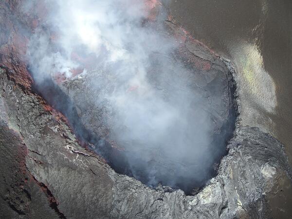
April 15, 2025 — UAS view into north vent
During UAS (uncrewed aircraft systems) overflights on April 15, the north vent within Halemaʻumaʻu at the summit of Kīlauea was not emitting as much volcanic gas as its southern counterpart, and it did not glow as hot in thermal images.

April 9, 2025 — Kīlauea eruption episode 17
Helicopter overflight and a field visit by USGS Hawaiian Volcano Observatory geologists to the crater rim to observe the lava fountaining in episode 17 of the ongoing summit eruption of Kīlauea.
Helicopter overflight and a field visit by USGS Hawaiian Volcano Observatory geologists to the crater rim to observe the lava fountaining in episode 17 of the ongoing summit eruption of Kīlauea.
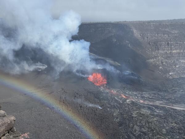
April 9, 2025 — Kīlauea eruption episode 17
This photo shows the low fountaining in the south vent, at the summit of Kīlauea, just minutes before the fountaining ended at 9:45 a.m. HST on April 9, 2025. Visibility in the caldera was variable this morning with passing showers. USGS photo by M. Patrick.
This photo shows the low fountaining in the south vent, at the summit of Kīlauea, just minutes before the fountaining ended at 9:45 a.m. HST on April 9, 2025. Visibility in the caldera was variable this morning with passing showers. USGS photo by M. Patrick.

April 9, 2025 — Kīlauea lava sample
A USGS Hawaiian Volcano Observatory geologist collects a molten lava sample for geochemical analysis, which will inform hazard analyses of the ongoing eruption. This lava flow was supplied by lava fountaining in the western end of the crater, during episode 17 of the ongoing summit eruption of Kīlauea. USGS photo by M. Patrick.
A USGS Hawaiian Volcano Observatory geologist collects a molten lava sample for geochemical analysis, which will inform hazard analyses of the ongoing eruption. This lava flow was supplied by lava fountaining in the western end of the crater, during episode 17 of the ongoing summit eruption of Kīlauea. USGS photo by M. Patrick.

April 9, 2025 — Kīlauea lava flows
During a monitoring overflight at 7:15 a.m. HST on April 9, 2025, USGS Hawaiian Volcano Observatory field crews observed Pāhoehoe flows on the floor of Halema‘uma‘u crater at the summit of Kīlauea. These flows were fed by the south vent fountains, which ceased activity around 9:45 a.m. this morning, April 9, marking the end of episode 17. USGS photo by E.
During a monitoring overflight at 7:15 a.m. HST on April 9, 2025, USGS Hawaiian Volcano Observatory field crews observed Pāhoehoe flows on the floor of Halema‘uma‘u crater at the summit of Kīlauea. These flows were fed by the south vent fountains, which ceased activity around 9:45 a.m. this morning, April 9, marking the end of episode 17. USGS photo by E.
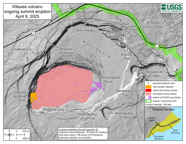
April 9, 2025—Kīlauea summit eruption reference map
April 9, 2025—Kīlauea summit eruption reference mapThis reference map depicts the Kīlauea summit eruption within Halema‘uma‘u crater that began on December 23, 2024. As of this posting on April 9, the eruption has had seventeen episodes, with the most recent concluding earlier this morning.
April 9, 2025—Kīlauea summit eruption reference map
April 9, 2025—Kīlauea summit eruption reference mapThis reference map depicts the Kīlauea summit eruption within Halema‘uma‘u crater that began on December 23, 2024. As of this posting on April 9, the eruption has had seventeen episodes, with the most recent concluding earlier this morning.

April 9, 2025 — Aerial view of the eruptive vents at Kīlauea
April 9, 2025 — Aerial view of the eruptive vents at KīlaueaDuring a monitoring overflight on April 9, 2025, USGS Hawaiian Volcano Observatory field crews observed that the ponded lava in the north vent from April 8 had drained and/or collapsed. The south vent was still active, with fountaining sending lava flows across the floor of Halema‘uma‘u. USGS photo by K. Lynn.
April 9, 2025 — Aerial view of the eruptive vents at Kīlauea
April 9, 2025 — Aerial view of the eruptive vents at KīlaueaDuring a monitoring overflight on April 9, 2025, USGS Hawaiian Volcano Observatory field crews observed that the ponded lava in the north vent from April 8 had drained and/or collapsed. The south vent was still active, with fountaining sending lava flows across the floor of Halema‘uma‘u. USGS photo by K. Lynn.

April 9, 2025 — Thermal map of episode 17 lava flow at Kīlauea summit
April 9, 2025 — Thermal map of episode 17 lava flow at Kīlauea summitThis thermal map was taken on the 7 a.m. overflight of Kīlauea summit on April 9, 2025, and shows the expansive lava flow covering the floor of Halema‘uma‘u, supplied by lava fountains at the vent. As in earlier episodes, the lava exited the vent into a short channel that fed a broad perched lava pond.
April 9, 2025 — Thermal map of episode 17 lava flow at Kīlauea summit
April 9, 2025 — Thermal map of episode 17 lava flow at Kīlauea summitThis thermal map was taken on the 7 a.m. overflight of Kīlauea summit on April 9, 2025, and shows the expansive lava flow covering the floor of Halema‘uma‘u, supplied by lava fountains at the vent. As in earlier episodes, the lava exited the vent into a short channel that fed a broad perched lava pond.
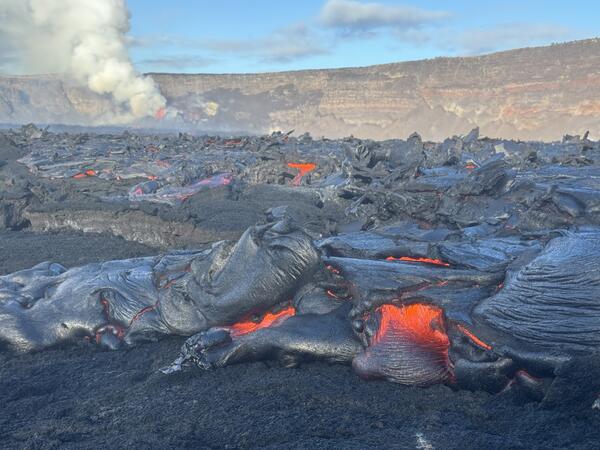
April 9, 2025 — Kīlauea lava flow
Lava fountains during episode 17 supplied lava into a broad lava flow field covering much of the Halema‘uma‘u crater floor. Here, a small lobe of pāhoehoe breaks out at the far eastern end of the crater. The lava fountain and its degassing plume are visible in the distance. USGS photo by M. Patrick
Lava fountains during episode 17 supplied lava into a broad lava flow field covering much of the Halema‘uma‘u crater floor. Here, a small lobe of pāhoehoe breaks out at the far eastern end of the crater. The lava fountain and its degassing plume are visible in the distance. USGS photo by M. Patrick
April 9, 2025 — Kīlauea summit eruption episode 17 overview
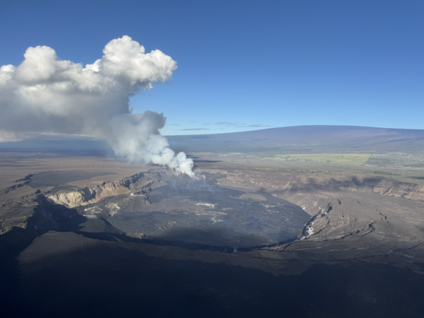
April 9, 2025 — Kīlauea summit eruption episode 17 overviewA helicopter overflight the morning of April 9, 2025, at 7 a.m. HST provided views of the episode 17 lava fountaining at the summit of Kīlauea just a few hours before it ended. The lava fountains were supplying lava into a flow that covered much of the Halema‘uma‘u crater floor. The fountains also produced a towering outgassing plume above the summit.
April 9, 2025 — Kīlauea summit eruption episode 17 overview
April 9, 2025 — Kīlauea summit eruption episode 17 overviewA helicopter overflight the morning of April 9, 2025, at 7 a.m. HST provided views of the episode 17 lava fountaining at the summit of Kīlauea just a few hours before it ended. The lava fountains were supplying lava into a flow that covered much of the Halema‘uma‘u crater floor. The fountains also produced a towering outgassing plume above the summit.
Visualization of volcanic hazards
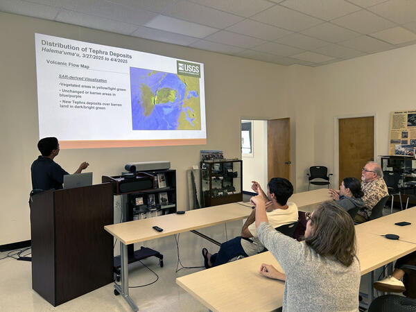
A USGS IT Specialist presents a visualization of volcanic hazards derived via satellite radar systems. IT systems facilitating the swift and accurate production of such solutions will be vital to the success of NVEWS. USGS image.
A USGS IT Specialist presents a visualization of volcanic hazards derived via satellite radar systems. IT systems facilitating the swift and accurate production of such solutions will be vital to the success of NVEWS. USGS image.
April 8, 2025 — Geologists on western rim of Halemaʻumaʻu
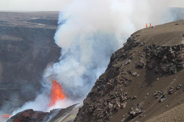
April 8, 2025 — Geologists on western rim of HalemaʻumaʻuIn the afternoon of April 8, USGS Hawaiian Volcano Observatory geologists visited the western rim of Halemaʻumaʻu crater to observe the ongoing Kīlauea summit eruption during its seventeenth episode. This telephoto view of the geologists shows them taking laser rangefinder measurements of lava fountains at the active eruptive vent below them within the crater.
April 8, 2025 — Geologists on western rim of Halemaʻumaʻu
April 8, 2025 — Geologists on western rim of HalemaʻumaʻuIn the afternoon of April 8, USGS Hawaiian Volcano Observatory geologists visited the western rim of Halemaʻumaʻu crater to observe the ongoing Kīlauea summit eruption during its seventeenth episode. This telephoto view of the geologists shows them taking laser rangefinder measurements of lava fountains at the active eruptive vent below them within the crater.
April 8, 2025 — Inactive north vent in Halemaʻumaʻu
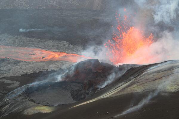
April 8, 2025 — Inactive north vent in HalemaʻumaʻuAs the day progressed on April 8, despite continued lava fountaining at the south vent (background right), activity declined at the north vent (foreground left). This afternoon photo captured from the western rim of Halemaʻumaʻu crater—looking to the south—shows the north vent's lava pond fully crusted over and sitting lower within the spatter cone.
April 8, 2025 — Inactive north vent in Halemaʻumaʻu
April 8, 2025 — Inactive north vent in HalemaʻumaʻuAs the day progressed on April 8, despite continued lava fountaining at the south vent (background right), activity declined at the north vent (foreground left). This afternoon photo captured from the western rim of Halemaʻumaʻu crater—looking to the south—shows the north vent's lava pond fully crusted over and sitting lower within the spatter cone.
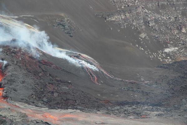
April 8, 2025 — Overflowing lava pond in north vent
April 8, 2025 — Overflowing lava pond in north ventWhile the south vent within Halemaʻumaʻu crater at the summit of Kīlauea has been actively fountaining on April 8, the north vent has hosted a lava pond with weak spatter. At times, this pond has overflowed to feed short lava flows down the flanks of the vent structure. USGS photo by M. Zoeller.
April 8, 2025 — Overflowing lava pond in north vent
April 8, 2025 — Overflowing lava pond in north ventWhile the south vent within Halemaʻumaʻu crater at the summit of Kīlauea has been actively fountaining on April 8, the north vent has hosted a lava pond with weak spatter. At times, this pond has overflowed to feed short lava flows down the flanks of the vent structure. USGS photo by M. Zoeller.
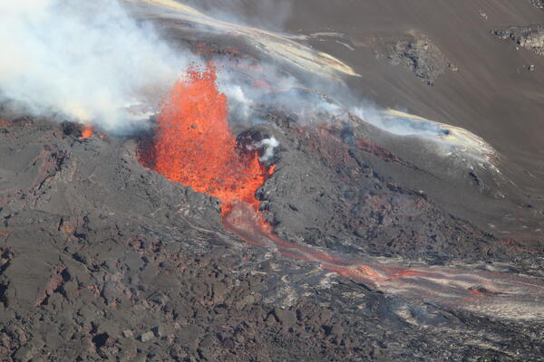
April 8, 2025 — Lava fountain in south vent
Following the onset of the Kīlauea summit eruption's seventeenth episode in the late evening of April 7, USGS Hawaiian Volcano Observatory geologists visited the southern rim of Halemaʻumʻau crater on the morning of April 8 to observe vent activity.
Following the onset of the Kīlauea summit eruption's seventeenth episode in the late evening of April 7, USGS Hawaiian Volcano Observatory geologists visited the southern rim of Halemaʻumʻau crater on the morning of April 8 to observe vent activity.
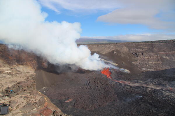
April 8, 2025 — Episode 17 of Kīlauea summit eruption
April 8, 2025 — Episode 17 of Kīlauea summit eruptionEpisode 17 of the ongoing Halemaʻumaʻu eruption at the summit of Kīlauea began last night, April 7, with lava flows erupting from the south vent at 10:15 p.m. HST. Low lava fountaining (100 feet, or 30 meters) was active overnight and continues this afternoon, feeding a lava flow on the crater floor. USGS photo by M. Zoeller.
April 8, 2025 — Episode 17 of Kīlauea summit eruption
April 8, 2025 — Episode 17 of Kīlauea summit eruptionEpisode 17 of the ongoing Halemaʻumaʻu eruption at the summit of Kīlauea began last night, April 7, with lava flows erupting from the south vent at 10:15 p.m. HST. Low lava fountaining (100 feet, or 30 meters) was active overnight and continues this afternoon, feeding a lava flow on the crater floor. USGS photo by M. Zoeller.

April 1 and 2, 2025 — Thermal maps of episode 16 summit activity at Kīlauea
April 1 and 2, 2025 — Thermal maps of episode 16 summit activity at KīlaueaThis set of thermal maps shows activity near the beginning and just after the end of episode 16 lava fountaining at the summit of Kīlauea. On April 1, lava fountaining was reaching over 200 meters (660 feet) and was beginning to produce a lava flow covering the western portion of the crater floor.
April 1 and 2, 2025 — Thermal maps of episode 16 summit activity at Kīlauea
April 1 and 2, 2025 — Thermal maps of episode 16 summit activity at KīlaueaThis set of thermal maps shows activity near the beginning and just after the end of episode 16 lava fountaining at the summit of Kīlauea. On April 1, lava fountaining was reaching over 200 meters (660 feet) and was beginning to produce a lava flow covering the western portion of the crater floor.

April 2, 2025 — Annotated thermal map of Kīlauea summit
April 2, 2025 — Annotated thermal map of Kīlauea summitThis close-up thermal map shows the crater floor at the summit of Kīlauea just an hour after the end of episode 16 lava fountaining on April 2. This map provides a good example of the different zones of lava flow activity on the crater floor that have been observed in many of the eruptive episodes.
April 2, 2025 — Annotated thermal map of Kīlauea summit
April 2, 2025 — Annotated thermal map of Kīlauea summitThis close-up thermal map shows the crater floor at the summit of Kīlauea just an hour after the end of episode 16 lava fountaining on April 2. This map provides a good example of the different zones of lava flow activity on the crater floor that have been observed in many of the eruptive episodes.

April 3, 2025 — Episode 16 lava fountaining, Kīlauea
April 3, 2025 — Episode 16 lava fountaining, KīlaueaLava fountaining during episode 16 of the ongoing summit eruption at Kīlauea. USGS webcam image.
April 3, 2025 — Episode 16 lava fountaining, Kīlauea
April 3, 2025 — Episode 16 lava fountaining, KīlaueaLava fountaining during episode 16 of the ongoing summit eruption at Kīlauea. USGS webcam image.
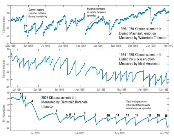
Ground tilt associated with episodic eruptions at Kīlauea
Ground tilt associated with episodic eruptions at KīlaueaGround tilt associated with episodic eruptions at Kīlauea. Top panel, two years of summit tilt spanning episodic fountaining at Maunaulu in 1969, as measured by a watertube tiltmeter at Uēkahuna bluff. Middle panel, an ideal aerosmith measurement of summit ground tilt during the initial years (1984-1986) of the Puʻuʻōʻō eruption that span a period o
Ground tilt associated with episodic eruptions at Kīlauea
Ground tilt associated with episodic eruptions at KīlaueaGround tilt associated with episodic eruptions at Kīlauea. Top panel, two years of summit tilt spanning episodic fountaining at Maunaulu in 1969, as measured by a watertube tiltmeter at Uēkahuna bluff. Middle panel, an ideal aerosmith measurement of summit ground tilt during the initial years (1984-1986) of the Puʻuʻōʻō eruption that span a period o
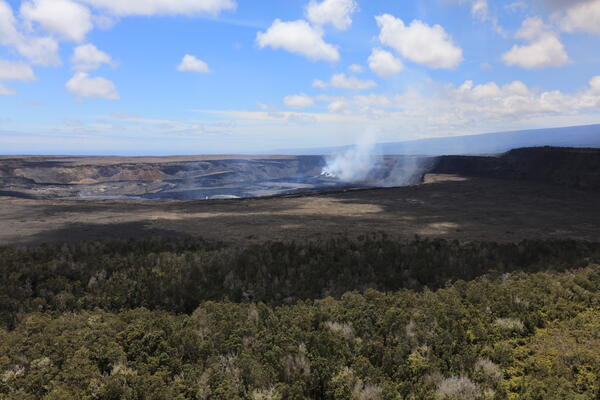
April 2, 2025 — Aerial view of Kaluapele, the caldera at the summit of Kīlauea
April 2, 2025 — Aerial view of Kaluapele, the caldera at the summit of KīlaueaAerial view of Kaluapele, the summit caldera of Kīlauea, hours after the end of episode 16 of the ongoing eruption in Halemaʻumaʻu. USGS photo by K. Lynn.
April 2, 2025 — Aerial view of Kaluapele, the caldera at the summit of Kīlauea
April 2, 2025 — Aerial view of Kaluapele, the caldera at the summit of KīlaueaAerial view of Kaluapele, the summit caldera of Kīlauea, hours after the end of episode 16 of the ongoing eruption in Halemaʻumaʻu. USGS photo by K. Lynn.