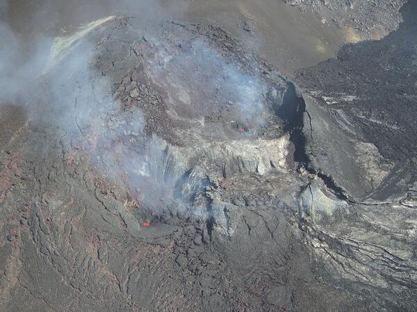
On April 18, USGS Hawaiian Volcano Observatory geologists flew UAS (uncrewed aircraft systems) into Halemaʻumaʻu to monitor the ongoing Kīlauea summit eruption. This oblique aerial photo provides an overview of the two eruptive vents, north (background) and south (foreground).
Images
Hawaiian Volcano Observatory images of eruptive activity, field work, and more.
On April 18, USGS Hawaiian Volcano Observatory geologists flew UAS (uncrewed aircraft systems) into Halemaʻumaʻu to monitor the ongoing Kīlauea summit eruption. This oblique aerial photo provides an overview of the two eruptive vents, north (background) and south (foreground).
During UAS (uncrewed aircraft systems) overflights on April 18, the north vent within Halemaʻumaʻu at the summit of Kīlauea was vigorously degassing although it did not host any obvious active lava. This high-angle aerial photo shows multiple openings in the base of the vent cone that glowed hot in simultaneously captured thermal images.
April 17, 2025—InSAR image of Kīlauea deformation associated with ongoing eruption
April 17, 2025—InSAR image of Kīlauea deformation associated with ongoing eruptionThis map shows deformation at Kīlauea volcano associated with the ongoing summit eruption that started on December 23, 2024. The image covers the timespan from April 9–17, 2025, using data recorded by the Italian Space Agency's (ASI) COSMO-SkyMed Second Generation satellite constellation.
April 17, 2025—InSAR image of Kīlauea deformation associated with ongoing eruption
April 17, 2025—InSAR image of Kīlauea deformation associated with ongoing eruptionThis map shows deformation at Kīlauea volcano associated with the ongoing summit eruption that started on December 23, 2024. The image covers the timespan from April 9–17, 2025, using data recorded by the Italian Space Agency's (ASI) COSMO-SkyMed Second Generation satellite constellation.
Satellite image and cross-section schematic showing changes in the Pohoiki area
Satellite image and cross-section schematic showing changes in the Pohoiki areaSatellite image showing changes in the Pohoiki area on the Island of Hawaiʻi. The pre-2018 coastline is shown in white, extent of the first and second phase of growth in blue (about 1 year after the end of the 2018 eruption), and the current active phase as seen in the satellite image from March 2024. Satellite image from GoogleEarth.
Satellite image and cross-section schematic showing changes in the Pohoiki area
Satellite image and cross-section schematic showing changes in the Pohoiki areaSatellite image showing changes in the Pohoiki area on the Island of Hawaiʻi. The pre-2018 coastline is shown in white, extent of the first and second phase of growth in blue (about 1 year after the end of the 2018 eruption), and the current active phase as seen in the satellite image from March 2024. Satellite image from GoogleEarth.
On April 15, USGS Hawaiian Volcano Observatory geologists flew UAS (uncrewed aircraft systems) into Halemaʻumaʻu to monitor the ongoing Kīlauea summit eruption.
During UAS (uncrewed aircraft systems) overflights on April 15, USGS-Hawaiian Volcano Observatory (HVO) staff monitor the UAS, which is visible just to the right of center in this image. HVO staff collected aerial imagery and volcanic gas concentration data during the UAS flights, which aids in volcanic hazard assessment of the ongoing Kīlauea summit eruption.
April 15, 2025 — Views into the eruptive vents at the summit of Kīlauea during a pause
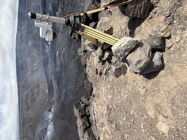
April 15, 2025 — Views into the eruptive vents at the summit of Kīlauea during a pauseA view of the north and south vents within Halemaʻumaʻu, Kīlauea volcano, on April 15, 2025, taken from the south rim of the caldera. USGS Hawaiian Volcano Observatory geologists measured the height of the crater wall behind the vents using a laser rangefinder.
April 15, 2025 — Views into the eruptive vents at the summit of Kīlauea during a pause
April 15, 2025 — Views into the eruptive vents at the summit of Kīlauea during a pauseA view of the north and south vents within Halemaʻumaʻu, Kīlauea volcano, on April 15, 2025, taken from the south rim of the caldera. USGS Hawaiian Volcano Observatory geologists measured the height of the crater wall behind the vents using a laser rangefinder.
April 15, 2025 — UAS monitoring flights at Kīlauea summit
April 15, 2025 — UAS monitoring flights at Kīlauea summitOn April 15, a USGS Hawaiian Volcano Observatory geologist prepares for a UAS (uncrewed aircraft systems) flight into Halemaʻumaʻu to monitor the ongoing Kīlauea summit eruption. UAS flights are conducted with the permission of Hawaiʻi Volcanoes National Park and aid in hazard assessment of ongoing volcanic activity.
April 15, 2025 — UAS monitoring flights at Kīlauea summit
April 15, 2025 — UAS monitoring flights at Kīlauea summitOn April 15, a USGS Hawaiian Volcano Observatory geologist prepares for a UAS (uncrewed aircraft systems) flight into Halemaʻumaʻu to monitor the ongoing Kīlauea summit eruption. UAS flights are conducted with the permission of Hawaiʻi Volcanoes National Park and aid in hazard assessment of ongoing volcanic activity.
During UAS (uncrewed aircraft systems) overflights on April 15, the north vent within Halemaʻumaʻu at the summit of Kīlauea was not emitting as much volcanic gas as its southern counterpart, and it did not glow as hot in thermal images.
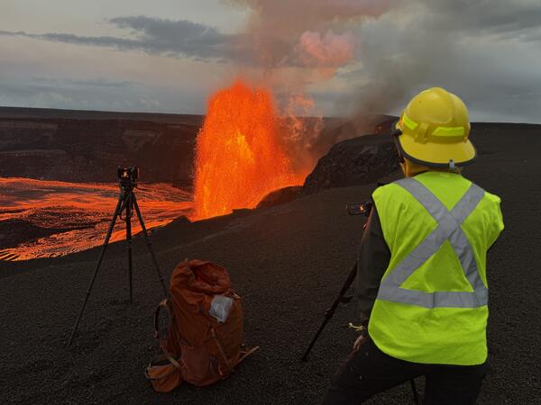
Helicopter overflight and a field visit by USGS Hawaiian Volcano Observatory geologists to the crater rim to observe the lava fountaining in episode 17 of the ongoing summit eruption of Kīlauea.
This photo shows the low fountaining in the south vent, at the summit of Kīlauea, just minutes before the fountaining ended at 9:45 a.m. HST on April 9, 2025. Visibility in the caldera was variable this morning with passing showers. USGS photo by M. Patrick.
A USGS Hawaiian Volcano Observatory geologist collects a molten lava sample for geochemical analysis, which will inform hazard analyses of the ongoing eruption. This lava flow was supplied by lava fountaining in the western end of the crater, during episode 17 of the ongoing summit eruption of Kīlauea. USGS photo by M. Patrick.
During a monitoring overflight at 7:15 a.m. HST on April 9, 2025, USGS Hawaiian Volcano Observatory field crews observed Pāhoehoe flows on the floor of Halema‘uma‘u crater at the summit of Kīlauea. These flows were fed by the south vent fountains, which ceased activity around 9:45 a.m. this morning, April 9, marking the end of episode 17. USGS photo by E.
April 9, 2025—Kīlauea summit eruption reference map
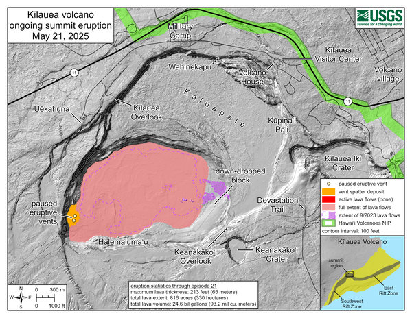
April 9, 2025—Kīlauea summit eruption reference mapThis reference map depicts the Kīlauea summit eruption within Halema‘uma‘u crater that began on December 23, 2024. As of this posting on April 9, the eruption has had seventeen episodes, with the most recent concluding earlier this morning.
April 9, 2025—Kīlauea summit eruption reference map
April 9, 2025—Kīlauea summit eruption reference mapThis reference map depicts the Kīlauea summit eruption within Halema‘uma‘u crater that began on December 23, 2024. As of this posting on April 9, the eruption has had seventeen episodes, with the most recent concluding earlier this morning.
April 9, 2025 — Aerial view of the eruptive vents at Kīlauea
April 9, 2025 — Aerial view of the eruptive vents at KīlaueaDuring a monitoring overflight on April 9, 2025, USGS Hawaiian Volcano Observatory field crews observed that the ponded lava in the north vent from April 8 had drained and/or collapsed. The south vent was still active, with fountaining sending lava flows across the floor of Halema‘uma‘u. USGS photo by K. Lynn.
April 9, 2025 — Aerial view of the eruptive vents at Kīlauea
April 9, 2025 — Aerial view of the eruptive vents at KīlaueaDuring a monitoring overflight on April 9, 2025, USGS Hawaiian Volcano Observatory field crews observed that the ponded lava in the north vent from April 8 had drained and/or collapsed. The south vent was still active, with fountaining sending lava flows across the floor of Halema‘uma‘u. USGS photo by K. Lynn.
April 9, 2025 — Thermal map of episode 17 lava flow at Kīlauea summit
April 9, 2025 — Thermal map of episode 17 lava flow at Kīlauea summitThis thermal map was taken on the 7 a.m. overflight of Kīlauea summit on April 9, 2025, and shows the expansive lava flow covering the floor of Halema‘uma‘u, supplied by lava fountains at the vent. As in earlier episodes, the lava exited the vent into a short channel that fed a broad perched lava pond.
April 9, 2025 — Thermal map of episode 17 lava flow at Kīlauea summit
April 9, 2025 — Thermal map of episode 17 lava flow at Kīlauea summitThis thermal map was taken on the 7 a.m. overflight of Kīlauea summit on April 9, 2025, and shows the expansive lava flow covering the floor of Halema‘uma‘u, supplied by lava fountains at the vent. As in earlier episodes, the lava exited the vent into a short channel that fed a broad perched lava pond.
Lava fountains during episode 17 supplied lava into a broad lava flow field covering much of the Halema‘uma‘u crater floor. Here, a small lobe of pāhoehoe breaks out at the far eastern end of the crater. The lava fountain and its degassing plume are visible in the distance. USGS photo by M. Patrick
April 9, 2025 — Kīlauea summit eruption episode 17 overview
April 9, 2025 — Kīlauea summit eruption episode 17 overviewA helicopter overflight the morning of April 9, 2025, at 7 a.m. HST provided views of the episode 17 lava fountaining at the summit of Kīlauea just a few hours before it ended. The lava fountains were supplying lava into a flow that covered much of the Halema‘uma‘u crater floor. The fountains also produced a towering outgassing plume above the summit.
April 9, 2025 — Kīlauea summit eruption episode 17 overview
April 9, 2025 — Kīlauea summit eruption episode 17 overviewA helicopter overflight the morning of April 9, 2025, at 7 a.m. HST provided views of the episode 17 lava fountaining at the summit of Kīlauea just a few hours before it ended. The lava fountains were supplying lava into a flow that covered much of the Halema‘uma‘u crater floor. The fountains also produced a towering outgassing plume above the summit.
A USGS IT Specialist presents a visualization of volcanic hazards derived via satellite radar systems. IT systems facilitating the swift and accurate production of such solutions will be vital to the success of NVEWS. USGS image.
April 8, 2025 — Geologists on western rim of Halemaʻumaʻu
April 8, 2025 — Geologists on western rim of HalemaʻumaʻuIn the afternoon of April 8, USGS Hawaiian Volcano Observatory geologists visited the western rim of Halemaʻumaʻu crater to observe the ongoing Kīlauea summit eruption during its seventeenth episode. This telephoto view of the geologists shows them taking laser rangefinder measurements of lava fountains at the active eruptive vent below them within the crater.
April 8, 2025 — Geologists on western rim of Halemaʻumaʻu
April 8, 2025 — Geologists on western rim of HalemaʻumaʻuIn the afternoon of April 8, USGS Hawaiian Volcano Observatory geologists visited the western rim of Halemaʻumaʻu crater to observe the ongoing Kīlauea summit eruption during its seventeenth episode. This telephoto view of the geologists shows them taking laser rangefinder measurements of lava fountains at the active eruptive vent below them within the crater.
April 8, 2025 — Inactive north vent in Halemaʻumaʻu
April 8, 2025 — Inactive north vent in HalemaʻumaʻuAs the day progressed on April 8, despite continued lava fountaining at the south vent (background right), activity declined at the north vent (foreground left). This afternoon photo captured from the western rim of Halemaʻumaʻu crater—looking to the south—shows the north vent's lava pond fully crusted over and sitting lower within the spatter cone.
April 8, 2025 — Inactive north vent in Halemaʻumaʻu
April 8, 2025 — Inactive north vent in HalemaʻumaʻuAs the day progressed on April 8, despite continued lava fountaining at the south vent (background right), activity declined at the north vent (foreground left). This afternoon photo captured from the western rim of Halemaʻumaʻu crater—looking to the south—shows the north vent's lava pond fully crusted over and sitting lower within the spatter cone.