



Recent eruptive episodes at the summit of Kīlauea have unfortunately been destructive to vegetation in the tephra fallout zone downwind of the lava fountains. However, several native plant species are demonstrating remarkable resilience in the harsh conditions.
Images
Hawaiian Volcano Observatory images of eruptive activity, field work, and more.
Filter Total Items: 4151

May 11, 2025 — ʻAmaʻu fern at Kīlauea volcano
Recent eruptive episodes at the summit of Kīlauea have unfortunately been destructive to vegetation in the tephra fallout zone downwind of the lava fountains. However, several native plant species are demonstrating remarkable resilience in the harsh conditions.

May 11, 2025 — Episode 21 panorama at Kīlauea volcano
May 11, 2025 — Episode 21 panorama at Kīlauea volcanoWhile visiting the western rim of Halemaʻumaʻu on May 11, USGS Hawaiian Volcano Observatory scientists watched an ānuenue (rainbow) stretch across the crater during episode 21 of the ongoing Kīlauea summit eruption. Lava fountains from the northern eruptive vent (right) were feeding extensive lava flows on the crater floor at the time. USGS photo by M. Zoeller.
May 11, 2025 — Episode 21 panorama at Kīlauea volcano
May 11, 2025 — Episode 21 panorama at Kīlauea volcanoWhile visiting the western rim of Halemaʻumaʻu on May 11, USGS Hawaiian Volcano Observatory scientists watched an ānuenue (rainbow) stretch across the crater during episode 21 of the ongoing Kīlauea summit eruption. Lava fountains from the northern eruptive vent (right) were feeding extensive lava flows on the crater floor at the time. USGS photo by M. Zoeller.

May 11, 2025 — Kīlauea episode 21 lava fountaining
May 11, 2025 — Kīlauea episode 21 lava fountainingEpisode 21 lava fountaining at the summit of Kīlauea produced a robust outgassing plume today, with the plume rising vertically and then carried downwind (towards the left side of the photo) towards the Ka‘ū district by the tradewinds. USGS photo by M. Patrick.
May 11, 2025 — Kīlauea episode 21 lava fountaining
May 11, 2025 — Kīlauea episode 21 lava fountainingEpisode 21 lava fountaining at the summit of Kīlauea produced a robust outgassing plume today, with the plume rising vertically and then carried downwind (towards the left side of the photo) towards the Ka‘ū district by the tradewinds. USGS photo by M. Patrick.

May 11, 2025 — North vent lava fountaining at Kīlauea volcano
May 11, 2025 — North vent lava fountaining at Kīlauea volcanoOn May 11, USGS Hawaiian Volcano Observatory scientists visited the western rim of Halemaʻumaʻu crater to observe episode 21 of the ongoing Kīlauea summit eruption.
May 11, 2025 — North vent lava fountaining at Kīlauea volcano
May 11, 2025 — North vent lava fountaining at Kīlauea volcanoOn May 11, USGS Hawaiian Volcano Observatory scientists visited the western rim of Halemaʻumaʻu crater to observe episode 21 of the ongoing Kīlauea summit eruption.

May 11, 2025 — Scientist watches episode 20 at Kīlauea volcano
May 11, 2025 — Scientist watches episode 20 at Kīlauea volcanoThis photo of a USGS Hawaiian Volcano Observatory scientist watching the ongoing Kīlauea summit eruption was captured on the western rim of Halemaʻumaʻu crater at the former site of the KWcam and F1cam webcams.
May 11, 2025 — Scientist watches episode 20 at Kīlauea volcano
May 11, 2025 — Scientist watches episode 20 at Kīlauea volcanoThis photo of a USGS Hawaiian Volcano Observatory scientist watching the ongoing Kīlauea summit eruption was captured on the western rim of Halemaʻumaʻu crater at the former site of the KWcam and F1cam webcams.

May 11, 2025 — Kīlauea episode 21
Passing showers resulted in variable visibility across the caldera in the afternoon of May 11, but clear views showed that the lava fountaining at the summit produced a towering outgassing plume. This photo was taken from the eastern caldera rim. USGS photo by M. Patrick.
Passing showers resulted in variable visibility across the caldera in the afternoon of May 11, but clear views showed that the lava fountaining at the summit produced a towering outgassing plume. This photo was taken from the eastern caldera rim. USGS photo by M. Patrick.

May 11, 2025 — Episode 21 north vent lava fountain and plume at Kīlauea volcano
May 11, 2025 — Episode 21 north vent lava fountain and plume at Kīlauea volcanoKīlauea volcano's episode 21 occurred on May 11, 2025. This photo was taken a little more than an hour after lava fountaining started, and shows the north vent lava fountain with a volcanic gas plume rising above it. The height from the crater floor to the top of the cliff behind the fountain is approximately 540 feet (165 meters).
May 11, 2025 — Episode 21 north vent lava fountain and plume at Kīlauea volcano
May 11, 2025 — Episode 21 north vent lava fountain and plume at Kīlauea volcanoKīlauea volcano's episode 21 occurred on May 11, 2025. This photo was taken a little more than an hour after lava fountaining started, and shows the north vent lava fountain with a volcanic gas plume rising above it. The height from the crater floor to the top of the cliff behind the fountain is approximately 540 feet (165 meters).

May 11, 2025 — Episode 21 lava fountaining at Kīlauea summit
May 11, 2025 — Episode 21 lava fountaining at Kīlauea summitA dusk view of lava fountaining from the north vent at the summit of Kīlauea. Fountaining began during the early afternoon of May 11 and continued into the evening, providing good sunset views from the caldera rim. USGS photo by M. Patrick.
May 11, 2025 — Episode 21 lava fountaining at Kīlauea summit
May 11, 2025 — Episode 21 lava fountaining at Kīlauea summitA dusk view of lava fountaining from the north vent at the summit of Kīlauea. Fountaining began during the early afternoon of May 11 and continued into the evening, providing good sunset views from the caldera rim. USGS photo by M. Patrick.

Photo compilation of episodes 1–20 of the ongoing eruption at the summit of Kīlauea,
Photo compilation of episodes 1–20 of the ongoing eruption at the summit of Kīlauea,Photo compilation of episodes 1–20 of the ongoing eruption at the summit of Kīlauea, including webcam imagery and photos taken by USGS Hawaiian Volcano Observatory scientists on the ground and during helicopter overflights. In all photos except for episode 7, the south vent is on the left and the north vent is on the right.
Photo compilation of episodes 1–20 of the ongoing eruption at the summit of Kīlauea,
Photo compilation of episodes 1–20 of the ongoing eruption at the summit of Kīlauea,Photo compilation of episodes 1–20 of the ongoing eruption at the summit of Kīlauea, including webcam imagery and photos taken by USGS Hawaiian Volcano Observatory scientists on the ground and during helicopter overflights. In all photos except for episode 7, the south vent is on the left and the north vent is on the right.

May 7, 2025 — View into north vent at Kīlauea volcano
May 7, 2025 — View into north vent at Kīlauea volcanoA view looking down on north vent (center) of the ongoing eruption within Halema‘uma‘u at Kīlauea volcano, about 13 hours after the end of episode 20. The south vent is degassing (white vapor rising) on the right side of the photo.
May 7, 2025 — View into north vent at Kīlauea volcano
May 7, 2025 — View into north vent at Kīlauea volcanoA view looking down on north vent (center) of the ongoing eruption within Halema‘uma‘u at Kīlauea volcano, about 13 hours after the end of episode 20. The south vent is degassing (white vapor rising) on the right side of the photo.

May 7, 2025 — Lava ooze-out at Kīlauea volcano 13 hours after episode 20
May 7, 2025 — Lava ooze-out at Kīlauea volcano 13 hours after episode 20On May 7, 2025, about 13 hours after the end of episode 20 of the ongoing eruption at Kīlauea volcano, USGS Hawaiian Volcano Observatory scientists observed a lava ooze-out (center left in image) north of north vent (right side of image).
May 7, 2025 — Lava ooze-out at Kīlauea volcano 13 hours after episode 20
May 7, 2025 — Lava ooze-out at Kīlauea volcano 13 hours after episode 20On May 7, 2025, about 13 hours after the end of episode 20 of the ongoing eruption at Kīlauea volcano, USGS Hawaiian Volcano Observatory scientists observed a lava ooze-out (center left in image) north of north vent (right side of image).

May 7, 2025 — View of north vent at Kīlauea volcano
May 7, 2025 — View of north vent at Kīlauea volcanoA view of north vent of the ongoing eruption within Halema‘uma‘u at Kīlauea volcano, about 12 hours after the end of episode 20. The solidified lava with a smooth silvery appearance in the center of the photo was produced as lava overflowed from north vent.
May 7, 2025 — View of north vent at Kīlauea volcano
May 7, 2025 — View of north vent at Kīlauea volcanoA view of north vent of the ongoing eruption within Halema‘uma‘u at Kīlauea volcano, about 12 hours after the end of episode 20. The solidified lava with a smooth silvery appearance in the center of the photo was produced as lava overflowed from north vent.

May 7, 2025 — Close-up view into north vent at Kīlauea volcano
May 7, 2025 — Close-up view into north vent at Kīlauea volcanoTelephoto view looking into north vent (center) of the ongoing eruption within Halema‘uma‘u at Kīlauea volcano, about 13 hours after the end of episode 20. A conduit approximately 20 meters (66 feet) across is visible inside north vent (center bottom of image), which is approximately 60 meters (197 feet) across.
May 7, 2025 — Close-up view into north vent at Kīlauea volcano
May 7, 2025 — Close-up view into north vent at Kīlauea volcanoTelephoto view looking into north vent (center) of the ongoing eruption within Halema‘uma‘u at Kīlauea volcano, about 13 hours after the end of episode 20. A conduit approximately 20 meters (66 feet) across is visible inside north vent (center bottom of image), which is approximately 60 meters (197 feet) across.

May 6, 2025 — Telephoto view of the north vent erupting at Kīlauea volcano
May 6, 2025 — Telephoto view of the north vent erupting at Kīlauea volcanoDusk view of episode 20 fountaining activity at the north vent within Halemaʻumaʻu at the summit of Kīlauea. This photograph was taken from just east of the Kīlauea Overlook within Hawaiʻi Volcanoes National Park. The pali (cliff) of Kaluapele (Kīlauea summit caldera) is visible in the foreground, while a plume of volcanic gas is illuminated in the dusk light.
May 6, 2025 — Telephoto view of the north vent erupting at Kīlauea volcano
May 6, 2025 — Telephoto view of the north vent erupting at Kīlauea volcanoDusk view of episode 20 fountaining activity at the north vent within Halemaʻumaʻu at the summit of Kīlauea. This photograph was taken from just east of the Kīlauea Overlook within Hawaiʻi Volcanoes National Park. The pali (cliff) of Kaluapele (Kīlauea summit caldera) is visible in the foreground, while a plume of volcanic gas is illuminated in the dusk light.
May 6, 2025 — North vent lava fountaining at Kīlauea volcano
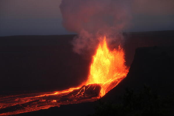
May 6, 2025 — North vent lava fountaining at Kīlauea volcanoDuring episode 20 of the ongoing eruption in Halemaʻumaʻu at the summit of Kīlauea, lava fountains reached about 500 feet (152 meters). The crater wall behind the vents is 492 feet (150 meters) high, and this photo shows that the top of the fountain from the north vent is reaching slightly higher than the crater wall.
May 6, 2025 — North vent lava fountaining at Kīlauea volcano
May 6, 2025 — North vent lava fountaining at Kīlauea volcanoDuring episode 20 of the ongoing eruption in Halemaʻumaʻu at the summit of Kīlauea, lava fountains reached about 500 feet (152 meters). The crater wall behind the vents is 492 feet (150 meters) high, and this photo shows that the top of the fountain from the north vent is reaching slightly higher than the crater wall.

May 6, 2025 — Telephoto view of north vent lava fountain at Kīlauea volcano
May 6, 2025 — Telephoto view of north vent lava fountain at Kīlauea volcanoThe continuous fountaining phase of episode 20 in the ongoing Kīlauea summit eruption was brief, lasting just 4.5 hours. The fountaining phase began at 5:28 p.m. HST and ended at 9:58 p.m. HST the evening of May 6, 2025. USGS photo by K. Mulliken.
May 6, 2025 — Telephoto view of north vent lava fountain at Kīlauea volcano
May 6, 2025 — Telephoto view of north vent lava fountain at Kīlauea volcanoThe continuous fountaining phase of episode 20 in the ongoing Kīlauea summit eruption was brief, lasting just 4.5 hours. The fountaining phase began at 5:28 p.m. HST and ended at 9:58 p.m. HST the evening of May 6, 2025. USGS photo by K. Mulliken.

May 6, 2025 — Episode 20 at Kīlauea volcano
Lava fountains and flows erupted from both the north and south vents during episode 20 of the ongoing eruption at the summit of Kīlauea. However, the north vent was much more active than the south vent, with lava fountains reaching estimated heights of more than 500 feet (150 meters). Fountains from the south vent reached heights of up to about 65 feet (20 meters).
Lava fountains and flows erupted from both the north and south vents during episode 20 of the ongoing eruption at the summit of Kīlauea. However, the north vent was much more active than the south vent, with lava fountains reaching estimated heights of more than 500 feet (150 meters). Fountains from the south vent reached heights of up to about 65 feet (20 meters).
May 5, 2025 — Lava dome fountain within north vent at Kīlauea volcano
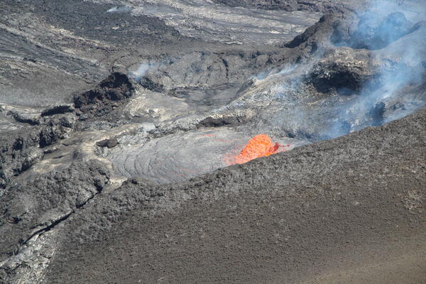
May 5, 2025 — Lava dome fountain within north vent at Kīlauea volcanoOn May 5, 2025, USGS Hawaiian Volcano Observatory scientists visiting the western rim of Halemaʻumaʻu crater watched several cycles of lava filling and draining within the north vent of Kīlauea's ongoing summit eruption. Dome fountains in the vent's lava pond reached approximately 6 meters (20 feet) in height.
May 5, 2025 — Lava dome fountain within north vent at Kīlauea volcano
May 5, 2025 — Lava dome fountain within north vent at Kīlauea volcanoOn May 5, 2025, USGS Hawaiian Volcano Observatory scientists visiting the western rim of Halemaʻumaʻu crater watched several cycles of lava filling and draining within the north vent of Kīlauea's ongoing summit eruption. Dome fountains in the vent's lava pond reached approximately 6 meters (20 feet) in height.

May 5, 2025 — Eruptive activity within north and south vents at Kīlauea volcano
May 5, 2025 — Eruptive activity within north and south vents at Kīlauea volcanoOn May 5, 2025, the north and south vents of Kīlauea's ongoing summit eruption were alternating in vigor over the course of 10-minute cycles.
May 5, 2025 — Eruptive activity within north and south vents at Kīlauea volcano
May 5, 2025 — Eruptive activity within north and south vents at Kīlauea volcanoOn May 5, 2025, the north and south vents of Kīlauea's ongoing summit eruption were alternating in vigor over the course of 10-minute cycles.

May 5, 2025 — Telephoto view of south vent at Kīlauea volcano
May 5, 2025 — Telephoto view of south vent at Kīlauea volcanoThis view of the south vent within Halemaʻumaʻu crater at the summit of Kīlauea was captured through the lens of a laser rangefinder device that Hawaiian Volcano Observatory scientists were using to measure eruptive features.
May 5, 2025 — Telephoto view of south vent at Kīlauea volcano
May 5, 2025 — Telephoto view of south vent at Kīlauea volcanoThis view of the south vent within Halemaʻumaʻu crater at the summit of Kīlauea was captured through the lens of a laser rangefinder device that Hawaiian Volcano Observatory scientists were using to measure eruptive features.

Seismic velocities at Kīlauea summit
Top panel: Map of seismic stations described in this article at Kīlauea volcano. Bottom panels: Changes in seismic velocity at (left) path between stations WRM and PUHI before the 2020 Kīlauea summit eruption, and (right) station BYL leading up to lava fountaining episode 23 on May 25, 2025.
Top panel: Map of seismic stations described in this article at Kīlauea volcano. Bottom panels: Changes in seismic velocity at (left) path between stations WRM and PUHI before the 2020 Kīlauea summit eruption, and (right) station BYL leading up to lava fountaining episode 23 on May 25, 2025.