
Alkaline-chloride waters from an eruption of Old Faithful flow over the edge of the white silica sinter terrace into the Firehole River. The orange coloration on the sinter terrace is due to thermophilic (high temperature) bacteria living in the warm fluids. Old Faithful Inn is in the background, with the wooded Summit Lake rhyolitic lava flow behind.&nb
Images
Images related to Yellowstone Volcano Observatory.
Filter Total Items: 761

Alkaline-chloride waters from Old Faithful
Alkaline-chloride waters from an eruption of Old Faithful flow over the edge of the white silica sinter terrace into the Firehole River. The orange coloration on the sinter terrace is due to thermophilic (high temperature) bacteria living in the warm fluids. Old Faithful Inn is in the background, with the wooded Summit Lake rhyolitic lava flow behind.&nb

Ear Spring, Yellowstone National Park
New thermal feature beneath the boardwalk on Geyser Hill, Upper Geyser Basin. Boards removed for better observation. Pump Geyser is mound at end of boardwalk. Old Faithful Inn in distance.
New thermal feature beneath the boardwalk on Geyser Hill, Upper Geyser Basin. Boards removed for better observation. Pump Geyser is mound at end of boardwalk. Old Faithful Inn in distance.

Thermal feature along Ferris Fork near Bechler River, Yellowstone
Thermal feature along Ferris Fork near Bechler River, YellowstoneAn unnamed but charismatic thermal feature alongside Ferris Fork, near the Bechler River. The center of the pool is roiling with gas bubbles, but not boiling! The pool is only about 180 degrees F (81 degrees C), and all the gas is bubbling up from underground.

Mules loaded with sampling equipment and supplies, Yellowstone
Mules loaded with sampling equipment and supplies, YellowstoneMules loaded with sampling equipment and supplies for a mission to collect gas and thermal water samples from the Bechler River area in the southwest part of Yellowstone National Park.

Ear Spring, Yellowstone National Park
Ear Spring photographed on September 16, 2018. Rocks and other debris on the ground surrounding the spring were ejected during the September 15 water eruption. The spring is dry in this photo.
Ear Spring photographed on September 16, 2018. Rocks and other debris on the ground surrounding the spring were ejected during the September 15 water eruption. The spring is dry in this photo.

UAV flight west side of Yellowstone River next to LaDuke Hot springs
UAV flight west side of Yellowstone River next to LaDuke Hot springsMontana Bureau of Mines and Geology and Montana Tech scientists preparing for a UAV flight on the west side of the Yellowstone River adjacent from LaDuke Hot Springs.

Geothermal seep that flows into Yellowstone River, LaDuke Hot Springs
Geothermal seep that flows into Yellowstone River, LaDuke Hot SpringsView of one of the geothermal seeps that flows into the Yellowstone River south of LaDuke Hot Spring.
Geothermal seep that flows into Yellowstone River, LaDuke Hot Springs
Geothermal seep that flows into Yellowstone River, LaDuke Hot SpringsView of one of the geothermal seeps that flows into the Yellowstone River south of LaDuke Hot Spring.

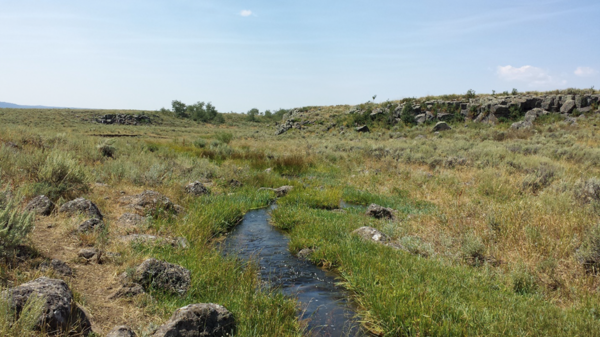
Steel pipe with small temperature sensors.
Left: steel pipe with small temperature sensors placed every few inches. Right: temperature pipe installed in the streambed.
Left: steel pipe with small temperature sensors placed every few inches. Right: temperature pipe installed in the streambed.

Serapeum, a Roman Marketplace in Pozzuoli, Italy
Serapeum, a Roman Marketplace in Pozzuoli, Italy, records deformation of Campi Flegrei caldera over two millennia.
Serapeum, a Roman Marketplace in Pozzuoli, Italy, records deformation of Campi Flegrei caldera over two millennia.

Dragon's Mouth, Yellowstone National Park
Dragon’s Mouth in the Mud Volcano Area of Yellowstone National Park.
Dragon’s Mouth in the Mud Volcano Area of Yellowstone National Park.
Basalts of Warm River and Shotgun Valley, Idaho
The Basalts of Warm River and Shotgun Valley, which erupted about 1.17 million years ago after the formation of Henrys Fork Caldera in southeast Idaho. Photo by Brandi Lawler, University of Wyoming, August 8, 2018.
The Basalts of Warm River and Shotgun Valley, which erupted about 1.17 million years ago after the formation of Henrys Fork Caldera in southeast Idaho. Photo by Brandi Lawler, University of Wyoming, August 8, 2018.

Hot springs waters measured on Yellowstone Lake floor
Hot springs waters measured on Yellowstone Lake floorHot spring waters with relatively high dissolved element concentrations on the floor of West Thumb, Yellowstone Lake. Image acquired by the Global Foundation for Ocean Exploration ROV Yogi on August 7, 2018.

Mushroom Pool, Lower Geyser Basin, Yellowstone National Park
Mushroom Pool, Lower Geyser Basin, Yellowstone National ParkMushroom Pool, Lower Geyser Basin, Yellowstone National Park.
Mushroom Pool, Lower Geyser Basin, Yellowstone National Park
Mushroom Pool, Lower Geyser Basin, Yellowstone National ParkMushroom Pool, Lower Geyser Basin, Yellowstone National Park.
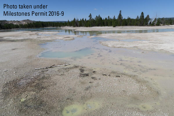
100 Spring Plain in Norris Geyser Basin, Yellowstone National Park
100 Spring Plain in Norris Geyser Basin, Yellowstone National Park100 Spring Plain in Norris Geyser Basin, Yellowstone National Park. The area is frequently flooded and impassable. Photo taken by Lauren Harrison in August 2018.
100 Spring Plain in Norris Geyser Basin, Yellowstone National Park
100 Spring Plain in Norris Geyser Basin, Yellowstone National Park100 Spring Plain in Norris Geyser Basin, Yellowstone National Park. The area is frequently flooded and impassable. Photo taken by Lauren Harrison in August 2018.
Pinehaven Basalt, Idaho
The Pinehaven Basalt, which erupted in Henrys Fork Caldera, southeast Idaho, about 35,000 years ago. Photo by Brandi Lawler, University of Wyoming, August 6, 2018.
The Pinehaven Basalt, which erupted in Henrys Fork Caldera, southeast Idaho, about 35,000 years ago. Photo by Brandi Lawler, University of Wyoming, August 6, 2018.

Fishing Cone, West Thumb
Fishing cone, a hot springs on the floor of Yellowstone Lake. The hot spring rim sits at lake level.
Fishing cone, a hot springs on the floor of Yellowstone Lake. The hot spring rim sits at lake level.

Sensor data logger recovered from floor of Yellowstone Lake
Sensor data logger recovered from floor of Yellowstone LakeA sensor data logger recovered from the floor of Yellowstone Lake in the Deep Hole area in 2018 shows signs of melting due to unexpectedly high temperatures in sediments up to ~3 ft (1 m) away from an active hydrothermal vent. Image acquired by the Global Foundation for Ocean Exploration ROV Yogi on August 4, 2018.

Thermally-deformed sensor recovered from the floor of Yellowstone Lake
Thermally-deformed sensor recovered from the floor of Yellowstone LakeSensor (top), deformed battery/electronics package (bottom), and titanium sheath (left) following recovery from vent location A in teh Deep Hole area on the floor of Yellowstone Lake.

Sensor deployed in the Deep Hole, Yellowstone Lake floor
Sensor deployed in the Deep Hole, Yellowstone Lake floorSensor deployed in the Deep Hole, east of Stevenson Island to monitor long-term temperature and chemical variations in an active vent. Image acquired by the Global Foundation for Ocean Exploration ROV Yogi on August 4, 2018.

Chemical/temperature sensor on the floor of Yellowstone Lake
Chemical/temperature sensor on the floor of Yellowstone LakeSensor (left) and battery/electronics package (right) at vent location A in the Deep Hole area of Yellowstone Lake. Photo was taken immediately before recovery from the lake floor. Notice the battery/electronics package slightly submerged in sediment.
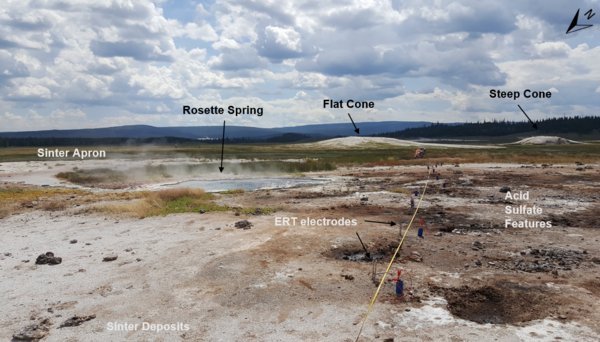
Electrical Resistivity Tomography (ERT) measurements near Rosette Spring, Yellowstone National Park
Electrical Resistivity Tomography (ERT) measurements near Rosette Spring, Yellowstone National ParkElectrical Resistivity Tomography (ERT) line R3 during setup of ERT and induced polarization measurement near Rosette Spring, Lower Geyser Basin. Photo by University of Wyoming Geophysics Team, July 17, 2018.