Sunset lake in Black Sand Basin of Yellowstone National Park
Sunset lake in Black Sand Basin of Yellowstone National ParkSunset lake in Black Sand Basin of Yellowstone National Park

Official websites use .gov
A .gov website belongs to an official government organization in the United States.
Secure .gov websites use HTTPS
A lock () or https:// means you’ve safely connected to the .gov website. Share sensitive information only on official, secure websites.
Images related to Yellowstone Volcano Observatory.

Sunset lake in Black Sand Basin of Yellowstone National Park
Sunset lake in Black Sand Basin of Yellowstone National Park

A weir constructed by Irving Friedman and Dan Norton to measure water discharge and to monitor changes in hydrothermal activity on a tributary flowing into Boundary Creek in southwest Yellowstone National Park. USGS photo by Shaul Hurwitz, September 17, 2017.
A weir constructed by Irving Friedman and Dan Norton to measure water discharge and to monitor changes in hydrothermal activity on a tributary flowing into Boundary Creek in southwest Yellowstone National Park. USGS photo by Shaul Hurwitz, September 17, 2017.

Focal mechanism determined by moment tensor analysis, which uses a model to fit the long-period (~10 s period or greater) ground motion records recorded at multiple locations.
Focal mechanism determined by moment tensor analysis, which uses a model to fit the long-period (~10 s period or greater) ground motion records recorded at multiple locations.

Inverted funnel connected to thermoplastic tubing used to collect gas from a hot spring pool near Lassen Peak, California.
Inverted funnel connected to thermoplastic tubing used to collect gas from a hot spring pool near Lassen Peak, California.

A newly emerged adult wetsalts tiger beetle. Photo by Robert K. D. Peterson, 2017.
A newly emerged adult wetsalts tiger beetle. Photo by Robert K. D. Peterson, 2017.

Equipment for measuring carbon dioxide and methane emissions used to monitor changes at Steamboat Geyser in 2019. The white cylinder is the chamber, which is lowered to the ground. Gases emitted from the ground surface accumulate in the chamber. An instrument in the cart continuously measures gas concentrations and carbon isotope compositions.
Equipment for measuring carbon dioxide and methane emissions used to monitor changes at Steamboat Geyser in 2019. The white cylinder is the chamber, which is lowered to the ground. Gases emitted from the ground surface accumulate in the chamber. An instrument in the cart continuously measures gas concentrations and carbon isotope compositions.

Upright petrified tree in Yellowstone National Park.
Upright petrified tree in Yellowstone National Park.

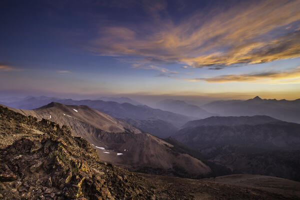
Amphitheater Mountain and Soda Butte Creek viewed from the Yellowstone National Park northeast entrance road.
Amphitheater Mountain and Soda Butte Creek viewed from the Yellowstone National Park northeast entrance road.

Fishing Cone, a small thermal feature near the shore of the West Thumb of Yellowstone Lake.
Fishing Cone, a small thermal feature near the shore of the West Thumb of Yellowstone Lake.

Hikers on Mount Everts near Mammoth Hot Springs, Yellowstone National Park.
Hikers on Mount Everts near Mammoth Hot Springs, Yellowstone National Park.

Panoramic of the West Yellowstone rhyolite lava flow taken along Highway 20 (between the West entrance of Yellowstone National Park and Madison Junction). The flow is approximately 111,000 years old and has a volume of about 41 km3 (10 mi3).
Panoramic of the West Yellowstone rhyolite lava flow taken along Highway 20 (between the West entrance of Yellowstone National Park and Madison Junction). The flow is approximately 111,000 years old and has a volume of about 41 km3 (10 mi3).

Big Southern Butte, a rhyolite dome located in the eastern Snake River Plain of Idaho. Photo by Devin Englestead, BLM (https://flic.kr/p/VYMDKz).
Big Southern Butte, a rhyolite dome located in the eastern Snake River Plain of Idaho. Photo by Devin Englestead, BLM (https://flic.kr/p/VYMDKz).

A geologist examples a basaltic lava flow along the Madison River, looking for an area that can yield samples suitable for 40Ar/39Ar geochronology. USGS photo by Jorge Vazquez, June 2017.
A geologist examples a basaltic lava flow along the Madison River, looking for an area that can yield samples suitable for 40Ar/39Ar geochronology. USGS photo by Jorge Vazquez, June 2017.
The geology of the Jim McClure-Jerry Peak Wilderness area in central Idaho includes the Challis volcanics, which erupted about 52–45 million years ago. Photo by Matt Liedecker, Bureau of Land Management, May 23, 2017 (https://www.flickr.com/photos/blmidaho/34808808006/).
The geology of the Jim McClure-Jerry Peak Wilderness area in central Idaho includes the Challis volcanics, which erupted about 52–45 million years ago. Photo by Matt Liedecker, Bureau of Land Management, May 23, 2017 (https://www.flickr.com/photos/blmidaho/34808808006/).

Geophysicist Elske de Zeeuw-van Dalfsen (Royal Netherlands Meteorological Institute) collects a gravity reading from a station near Gibbon Falls in Yellowstone National Park. Gravity data collection was completed under Yellowstone National Park research permit 7074.
Geophysicist Elske de Zeeuw-van Dalfsen (Royal Netherlands Meteorological Institute) collects a gravity reading from a station near Gibbon Falls in Yellowstone National Park. Gravity data collection was completed under Yellowstone National Park research permit 7074.

Plowing operations in Yellowstone National Park. Photo by Jake Frank, March 28, 2017.
Plowing operations in Yellowstone National Park. Photo by Jake Frank, March 28, 2017.
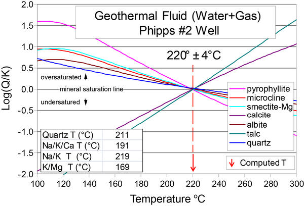
Computed mineral saturation indices (log(Q/K)) as a function of temperature for a geothermal water sample from Surprise Valley, California, after correction for CO2 loss due to degassing. Note that the mineral saturation points converge at 220 °C (428 °F) with a very small error of +/- 4 °C (7 °F).
Computed mineral saturation indices (log(Q/K)) as a function of temperature for a geothermal water sample from Surprise Valley, California, after correction for CO2 loss due to degassing. Note that the mineral saturation points converge at 220 °C (428 °F) with a very small error of +/- 4 °C (7 °F).

Photograph of eddy covariance and Multi-GAS stations that were deployed in a temporary configuration near Norris Geyser Basin in 2016. Research conducted under permit YELL-2016-SCI-7082.
Photograph of eddy covariance and Multi-GAS stations that were deployed in a temporary configuration near Norris Geyser Basin in 2016. Research conducted under permit YELL-2016-SCI-7082.

Helicopter with airborne electromagnetics sensors dangling beneath as it flies over a portion of Yellowstone National Park. Photo by Jeff Hungerford, November 2016.
Helicopter with airborne electromagnetics sensors dangling beneath as it flies over a portion of Yellowstone National Park. Photo by Jeff Hungerford, November 2016.

Kullenberg coring platform from the University of Minnesota-Twin Cities Continental Scientific Drilling facility used to collect long (up to 12 m, or 40 feet) sediment cores from Yellowstone Lake. Photo taken in September 2016 by Lisa Morgan.
Kullenberg coring platform from the University of Minnesota-Twin Cities Continental Scientific Drilling facility used to collect long (up to 12 m, or 40 feet) sediment cores from Yellowstone Lake. Photo taken in September 2016 by Lisa Morgan.

Cut polycarbonate sections of sediment core collected from core YL16-3A from the Deep Hole, the deepest part of Yellowstone Lake at about 119 m (390 feet) depth, southeast of Stevenson Island. Photo taken in September 2016 by Lisa Morgan.
Cut polycarbonate sections of sediment core collected from core YL16-3A from the Deep Hole, the deepest part of Yellowstone Lake at about 119 m (390 feet) depth, southeast of Stevenson Island. Photo taken in September 2016 by Lisa Morgan.