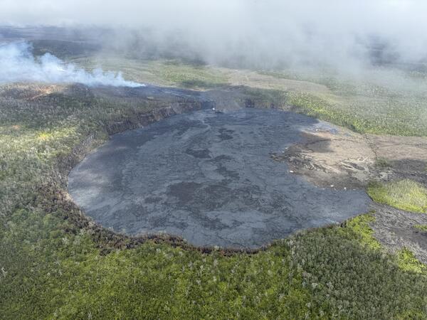
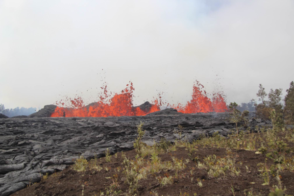
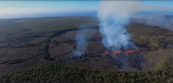
This video, taken during a Hawaiian Volcano Observatory morning overflight of Kīlaueaʻs middle East Rift Zone on September 16, 2024, shows new lava flows erupted over about an hour during the evening on September 15, 2024.
All Multimedia
Access all multimedia to include images, video, audio, webcams, before-after imagery, and more. Filter and explore with filtering options to refine search.

This video, taken during a Hawaiian Volcano Observatory morning overflight of Kīlaueaʻs middle East Rift Zone on September 16, 2024, shows new lava flows erupted over about an hour during the evening on September 15, 2024.

During a USGS Hawaiian Volcano Observatory overflight at approximately 10:30 a.m. HST on September 16, geologists observed freshly erupted lava west of Nāpau Crater on the remote middle East Rift Zone of Kīlauea, within Hawaiʻi Volcanoes National Park. This eruption likely occurred between approximately 9–10 p.m. HST on September 15.
Sounds from a large herd of walruses resting on Alaskan shores of the Chukchi Sea recorded. Deep full barks and calls of individual walruses near the edge of the herd are audible over a continuous rhythmic humming sound that arises from the calls of tens of thousands of walrsues from deeper within the herd.


This Eyes on Earth episode is the third in our series on using Landsat for coastal studies. We talk to physical geographer Jeff Danielson about bathymetry and how it is critical for coastal modeling. Bathymetry captures the shape of underwater topography, and satellite-derived bathymetry helps fill in areas where there are data gaps.

Is it true that there's oil in Yellowstone? Watch this month's Yellowstone Monthly update and find out.


In this episode of Eyes on Earth, we talked with some of the interns who worked at EROS this summer. They shared their experiences learning about the cloud, AI, wildland fire research, terrestrial lidar scanning, and more. The common theme among them was recognizing the value of the EROS mission and noticing the passion their co-workers demonstrated in their work.

Prolonged drought has lowered water levels in Laguna Bustillos in Chihuahua State, Mexico, killing thousands of fish.

This is an Office of International Programs (OIP) science highlight featuring groundwater remote sensing and optimizations in Kenya.

Biscuit Basin Update; 65th Anniversary — M7.3 Hebgen Lake Quake (Yellowstone Monthly Update - Aug 2024)
linkIn this month's video, we update you on the Biscuit Basin explosion on July 23, 2024, and discuss the 65th anniversary of the M7.3 Hegben Lake earthquake.
Biscuit Basin Update; 65th Anniversary — M7.3 Hebgen Lake Quake (Yellowstone Monthly Update - Aug 2024)
linkIn this month's video, we update you on the Biscuit Basin explosion on July 23, 2024, and discuss the 65th anniversary of the M7.3 Hegben Lake earthquake.


This episode of Eyes on Earth is the second in a series about how Landsat is helping researchers study coastal changes. The first one was about mapping changes to beaches in California and using Landsat to create models to predict how the coastline may change in the future because of sea level rise and coastal erosion.


In this episode of Eyes on Earth, we begin a series on Landsat’s usefulness in coastal studies. First, we talk with Sean Vitousek, a USGS research oceanographer, about changes to beaches in California and how he is using Landsat and other data to create models that can predict how the coastline may change in the future because of sea level rise and coastal erosion.
The Smokehouse Creek Fire started about 1 mile north of Stinnett, Texas on February 26th, 2024. Three days later, the fire had consumed over 1 million acres. With a total area of 1,654 square miles, it became the largest fire on record in Texas. That's larger than New York's Long Island.

Up until the 1950s, visitors to the Old Faithful area could take a dip. Not at a geyser, but in a real swimming pool. The full story is in this month’s video update.

Aerial image of the Southwest Rift Zone eruption of Kīlauea, viewed during an overflight at approximately 6 a.m. on June 3, 2024. USGS image.

Aerial image of the Southwest Rift Zone eruption of Kīlauea, viewed during an overflight at approximately 6 a.m. on June 3, 2024. USGS image.

Aerial video of the Southwest Rift Zone eruption of Kīlauea, viewed during an overflight at approximately 6 a.m. on June 3, 2024. USGS video.
During an overflight at approximately 6 a.m., USGS Hawaiian Volcano Observatory geologists observed the fissures system that opened on the upper portion of the Southwest Rift Zone early this morning. Approximately half a mile (about 1 km) in length, only the southwest portion of the system was active by daylight.
Fresh lava spatter litters the ground next to a new lava flow from the Kīlauea Southwest Rift Zone fissure eruption of June 3 2024
linkFrothy, glassy fragments of lava from the fountains of Kīlauea's June 3 eruption fissures were found scattered around newly-erupted lava flows. These tephra contain valuable geochemical information about the magma which fueled the eruption. USGS image by D. Downs.

The glow from the eruption of Kīlauea volcano, visible from Volcano House in Hawai'i Volcanoes National Park during the early morning hours of June 3. Image courtesy of Volcano House.

The glow from the eruption of Kīlauea volcano, visible from Volcano House in Hawai'i Volcanoes National Park during the early morning hours of June 3. Image courtesy of Volcano House.
Scientists observed cracks in previous eruptive surfaces near the new fissure eruption southwest of Kīlauea's summit on June 3, 2024. These cracks ranged from a few centimeters (inches) to approximately 2 meters (6.6 feet) wide.