
U.S. flag

An official website of the United States government

All Multimedia

Access all multimedia to include images, video, audio, webcams, before-after imagery, and more. Filter and explore with filtering options to refine search. 

Filter Total Items: 24981
An invasive Cuban treefrog in New Orleans, LA.
Outstanding in the Field (Ep 4): Amphibian Surveys – Call of the Frog
An invasive Cuban treefrog in New Orleans, LA.
Outstanding in the Field (Ep 4): Amphibian Surveys – Call of the Frog

The USGS Ecosystems Mission Area brings you Outstanding in the Field, a series of stories about our science, our adventures, and our efforts to better understand our fish and wildlife and the ecosystems that support them. In this episode we describe the USGS’s efforts to track frog populations in the southeast United States. 
 

The USGS Ecosystems Mission Area brings you Outstanding in the Field, a series of stories about our science, our adventures, and our efforts to better understand our fish and wildlife and the ecosystems that support them. In this episode we describe the USGS’s efforts to track frog populations in the southeast United States. 


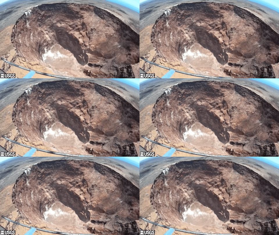
Overflight of Pu‘u ‘Ō‘ō on August 22

Pu‘u ‘Ō‘ō remains quiet. Clear weather during HVO's August 22 overflight provided good views into the drained crater. Rubble from crater wall collapses has filled in much of the deeper part of the crater, with the bottom now at about 250 meters (820 feet) below the east rim. The curvature of the horizon is caused by the wide-angle view of the camera.

Pu‘u ‘Ō‘ō remains quiet. Clear weather during HVO's August 22 overflight provided good views into the drained crater. Rubble from crater wall collapses has filled in much of the deeper part of the crater, with the bottom now at about 250 meters (820 feet) below the east rim. The curvature of the horizon is caused by the wide-angle view of the camera.

The cyanobacteria Gleotrichia shown under a microscope from a water sample collected at Ek Lake Trail
The cyanobacteria Gleotrichia shown under a microscope

The cyanobacteria Gleotrichia shown under a microscope from a water sample collected at Ek Lake Trail, a popular recreational area in Kabetogama Lake where algal blooms frequently occur. Gleotrichia  can produce microcystin.

The cyanobacteria Gleotrichia shown under a microscope from a water sample collected at Ek Lake Trail, a popular recreational area in Kabetogama Lake where algal blooms frequently occur. Gleotrichia  can produce microcystin.

image related to volcanoes. See description
Mauna Loa: Early morning view of Moku‘āweoweo

An early morning view looking north across Moku‘āweoweo, Mauna Loa's summit caldera, from a spot near the summit cabin on the volcano's south caldera rim. Frost covered much of the caldera floor that was still shadowed, and weak steaming issued from the usual areas. Overall, there were no significant changes observed at the summit.

An early morning view looking north across Moku‘āweoweo, Mauna Loa's summit caldera, from a spot near the summit cabin on the volcano's south caldera rim. Frost covered much of the caldera floor that was still shadowed, and weak steaming issued from the usual areas. Overall, there were no significant changes observed at the summit.

Overflight of Kīlauea summit

Clear weather afforded good views of the water pond in Halema‘uma‘u. No major changes were observed in the pond, but the water continues to slowly rise. The water surface was steaming, and its temperature was approximately 70 degrees Celsius (158 degrees Fahrenheit). For scale, the pond is about 70 meters (230 feet) long. USGS video by M. Patrick.

Clear weather afforded good views of the water pond in Halema‘uma‘u. No major changes were observed in the pond, but the water continues to slowly rise. The water surface was steaming, and its temperature was approximately 70 degrees Celsius (158 degrees Fahrenheit). For scale, the pond is about 70 meters (230 feet) long. USGS video by M. Patrick.

adult female Pacific walrus resting on the beach, Chukchi Sea, Alaska
Adult female Pacific walrus resting on beach, Chukchi Sea, Alaska

An adult female Pacific walrus resting on the beach of the eastern shore of the Chukchi Sea (Photo taken during USGS research efforts permitted under US Fish and Wildlife Service Permit No. MA801652-7.)

An adult female Pacific walrus resting on the beach of the eastern shore of the Chukchi Sea (Photo taken during USGS research efforts permitted under US Fish and Wildlife Service Permit No. MA801652-7.)

Aerial view of new thermal area near Tern Lake, Yellowstone.

Aerial view of the new thermal area, in the center left. The existing Tern Lake thermal area is the bright white patch of ground in the upper middle part of the image. West Tern Lake is in the lower right. Research conducted under NPS Geology Programs Milestones Permit 2016-9.

Aerial view of the new thermal area, in the center left. The existing Tern Lake thermal area is the bright white patch of ground in the upper middle part of the image. West Tern Lake is in the lower right. Research conducted under NPS Geology Programs Milestones Permit 2016-9.

Data Citation Tips from NASA's Land Processes DAAC

Interested in citing data and tools from NASA’s Land Processes Distributed Active Archive Center (LP DAAC)? This video will discuss why you should cite the data and data access tools you use in your research and where you can find information on the LP DAAC website to help you with your citation.

Interested in citing data and tools from NASA’s Land Processes Distributed Active Archive Center (LP DAAC)? This video will discuss why you should cite the data and data access tools you use in your research and where you can find information on the LP DAAC website to help you with your citation.

researchers on a boat at night with equipment
Night moves
Night moves
Night moves

Wayne Baldwin, Alex Nichols, and Brian Andrews get the 512i chirp subbottom profiler back on deck! The instrument weights ~500lbs. and requires the ships A-frame to lift it! We only take the chirp out of the water when we need to perform maintenance, transit rapidly, or for weather.

Wayne Baldwin, Alex Nichols, and Brian Andrews get the 512i chirp subbottom profiler back on deck! The instrument weights ~500lbs. and requires the ships A-frame to lift it! We only take the chirp out of the water when we need to perform maintenance, transit rapidly, or for weather.

researchers on a boat at night with equipment
Night moves
Night moves
Night moves

Wayne Baldwin, Alex Nichols, and Brian Andrews get the 512i chirp subbottom profiler back on deck! The instrument weights ~500lbs. and requires the ships A-frame to lift it! We only take the chirp out of the water when we need to perform maintenance, transit rapidly, or for weather.

Wayne Baldwin, Alex Nichols, and Brian Andrews get the 512i chirp subbottom profiler back on deck! The instrument weights ~500lbs. and requires the ships A-frame to lift it! We only take the chirp out of the water when we need to perform maintenance, transit rapidly, or for weather.

researchers on a boat with equipment
Night moves
Night moves
Night moves

Wayne Baldwin, Alex Nichols, and Brian Andrews get the 512i chirp subbottom profiler back on deck! The instrument weights ~500lbs. and requires the ships A-frame to lift it! We only take the chirp out of the water when we need to perform maintenance, transit rapidly, or for weather.

Wayne Baldwin, Alex Nichols, and Brian Andrews get the 512i chirp subbottom profiler back on deck! The instrument weights ~500lbs. and requires the ships A-frame to lift it! We only take the chirp out of the water when we need to perform maintenance, transit rapidly, or for weather.

Young male Pacific walrus on beach along the Chukchi Sea
Young male Pacific walrus on beach of eastern shore of the Chukchi Sea

A young male Pacific walrus moving up the beach of the eastern shore of the Chukchi Sea (Photo taken during USGS research efforts permitted under US Fish and Wildlife Service Permit No. MA801652-7.)

A young male Pacific walrus moving up the beach of the eastern shore of the Chukchi Sea (Photo taken during USGS research efforts permitted under US Fish and Wildlife Service Permit No. MA801652-7.)

A young male Pacific walrus resting along shoreline of the Chukchi Sea
Young male Pacific walrus resting on beach, Chukchi Sea, Alaska

A young male Pacific walrus resting on the beach of the eastern shore of the Chukchi Sea (Photo taken during USGS research efforts permitted under US Fish and Wildlife Service Permit No. MA801652-7.)

A young male Pacific walrus resting on the beach of the eastern shore of the Chukchi Sea (Photo taken during USGS research efforts permitted under US Fish and Wildlife Service Permit No. MA801652-7.)

Cyanobacterial bloom
Cyanobacterial bloom at Kabetogama Lake Visitor Center
Melissa Roach with pelican chicks at Smith Island

Northeast Region Photo Contest, August 2019, USGS at Work
Melissa Roach, biologist, with the Patuxent Bird Banding Lab, keeps pelican chicks that are waiting for banding from sneaking away into the marsh on Smith Island in Chesapeake Bay

Northeast Region Photo Contest, August 2019, USGS at Work
Melissa Roach, biologist, with the Patuxent Bird Banding Lab, keeps pelican chicks that are waiting for banding from sneaking away into the marsh on Smith Island in Chesapeake Bay

Tern Lake hydrothermal area from the ground, Yellowstone

View from the ground of the new thermal area near Tern Lake in Yellowstone National Park. Research conducted under NPS Geology Programs Milestones Permit 2016-9.

View from the ground of the new thermal area near Tern Lake in Yellowstone National Park. Research conducted under NPS Geology Programs Milestones Permit 2016-9.

Grand Canyon of the Yellowstone Lower Falls of Yellowstone River

Lower Falls of the Yellowstone River and the Grand Canyon of the Yellowstone, photographed during a helicopter flyover on August 19, 2019.

Placing a New Survey Reference Marker

Massachusetts student intern Michael Upton placing a new survey reference marker at a live recording groundwater well station.
 

Massachusetts student intern Michael Upton placing a new survey reference marker at a live recording groundwater well station.
 

Saffron cod
Saffron cod
Saffron cod
Saffron cod

Scientists anticipate that the fish community in the lagoons near Kaktovik, Alaska, Beaufort Sea, now includes more saffron cod (Eleginus gracilis) and larger saffron cod, like the one pictured here, given that the species has a higher thermal tolerance than many other co-occurring marine fishes.

Scientists anticipate that the fish community in the lagoons near Kaktovik, Alaska, Beaufort Sea, now includes more saffron cod (Eleginus gracilis) and larger saffron cod, like the one pictured here, given that the species has a higher thermal tolerance than many other co-occurring marine fishes.

Seven people stand together on the deck of a research vesselwearing life jackets and hard hats and everyone is smiling.
Science crew on research cruise

Science party on board University of Washington’s research vessel Rachel Carson, who conducted geophysical surveys and tripod deployment in and around Astoria Canyon. From left to right: Gerry Hatcher (USGS), Maureen Walton (USGS), Jenna Hill (USGS), Andrea Ogston (UW), Anna Boyar (UW), Alicia Balster-Gee (USGS), Evan Lahr (UW).

Science party on board University of Washington’s research vessel Rachel Carson, who conducted geophysical surveys and tripod deployment in and around Astoria Canyon. From left to right: Gerry Hatcher (USGS), Maureen Walton (USGS), Jenna Hill (USGS), Andrea Ogston (UW), Anna Boyar (UW), Alicia Balster-Gee (USGS), Evan Lahr (UW).

Was this page helpful?