
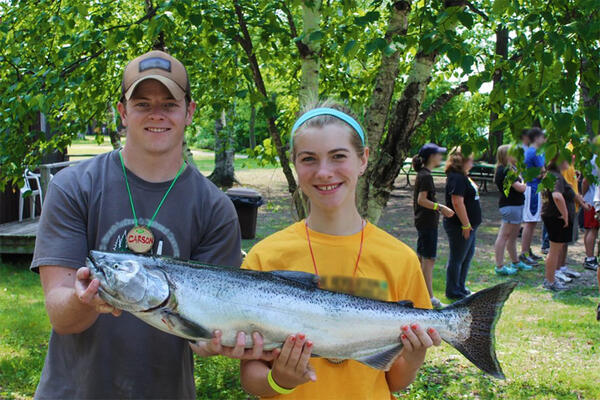
Carson Pritchard (left), a former GLSC contractor and 4-H camp counselor, shows off a Great Lakes Chinook salmon with a 4-H camper. Alewife are the primary forage of Chinook salmon. Consequently, understanding alewife age dynamics helps fishery managers balance predator numbers with the available prey.
All Multimedia
Access all multimedia to include images, video, audio, webcams, before-after imagery, and more. Filter and explore with filtering options to refine search.
Filter Total Items: 24926
Holding a Chinook Salmon
Carson Pritchard (left), a former GLSC contractor and 4-H camp counselor, shows off a Great Lakes Chinook salmon with a 4-H camper. Alewife are the primary forage of Chinook salmon. Consequently, understanding alewife age dynamics helps fishery managers balance predator numbers with the available prey.
")
Hovering Above—UAS’ Role in the 2018 Kīlauea Volcano Eruption (AD)
Hovering Above—UAS’ Role in the 2018 Kīlauea Volcano Eruption (AD)The 2018 Kīlauea Volcano eruption marked the first time the federal government used Unmanned Aircraft Systems (UAS) to assist in an eruption response in the United States.

Hovering Above—UAS’ Role in the 2018 Kīlauea Volcano Eruption Response
Hovering Above—UAS’ Role in the 2018 Kīlauea Volcano Eruption ResponseThe 2018 Kīlauea Volcano eruption marked the first time the federal government used Unmanned Aircraft Systems (UAS) to assist in an eruption response in the United States.

hydrothermal area disturbs boardwalk passage in Yellowstone
hydrothermal area disturbs boardwalk passage in YellowstoneA section of the Porcelain Basin Loop boardwalk in the Norris Geyser Basin was removed because the ground below sections of the boardwalk became too hot and made charcoal of the wood footings that support the structure. Luckily enough in this case, the boardwalk was shifted about 3 feet to avoid the new hot ground.

Illustration describes a barrier island from ocean to lagoon
Illustration describes a barrier island from ocean to lagoonIllustration shows the cross-section of a barrier island progressing from ocean (on the right) to marsh and then lagoon (on the left).
Illustration describes a barrier island from ocean to lagoon
Illustration describes a barrier island from ocean to lagoonIllustration shows the cross-section of a barrier island progressing from ocean (on the right) to marsh and then lagoon (on the left).

Image collage of USGS Ecosystems Mission Area scientists in the field.
Image collage of USGS Ecosystems Mission Area scientists in the field.Image collage of USGS Ecosystems Mission Area scientists in the field.
Image collage of USGS Ecosystems Mission Area scientists in the field.
Image collage of USGS Ecosystems Mission Area scientists in the field.Image collage of USGS Ecosystems Mission Area scientists in the field.

Images of multiple oceanside beaches and dunes at Fire Island New York
Images of multiple oceanside beaches and dunes at Fire Island New YorkFor more than 15 years, the USGS has actively studied natural and human changes to the shoreline, beaches, and dunes at Fire Island.
Images of multiple oceanside beaches and dunes at Fire Island New York
Images of multiple oceanside beaches and dunes at Fire Island New YorkFor more than 15 years, the USGS has actively studied natural and human changes to the shoreline, beaches, and dunes at Fire Island.

Industrial water use in 2015
Industrial water use in 2015

Irrigation water use withdrawals in 2015
Irrigation water use withdrawals in 2015

Juvenile Salt Marsh Harvest Mouse (Reithrodontomys raviventris)
Juvenile Salt Marsh Harvest Mouse (Reithrodontomys raviventris)USGS wildlife biologists holding a juvenile salt marsh harvest mouse (Reithrodontomys raviventris). The species is listed as "endangered" under the Endangered Species Act of 1973.

Kīlauea Volcano’s 2018 summit collapse
Kīlauea Volcano’s 2018 summit collapse, shown here on July 28 (left), and the lower East Rift Zone fissure 8 lava flow, shown here on July 2 (right), will be the focus of “Volcano Awareness Month” talks offered in January 2019.
Kīlauea Volcano’s 2018 summit collapse, shown here on July 28 (left), and the lower East Rift Zone fissure 8 lava flow, shown here on July 2 (right), will be the focus of “Volcano Awareness Month” talks offered in January 2019.

Landsat ARD tiles used for LCMAP
Image of Landsat ARD tiles used for USGS Land Change Monitoring, Assessment, and Projection (LCMAP).

Landslide near Potter Hill, Anchorage, Alaska
Landslide near Potter Hill, Anchorage, Alaska, after 2018 Anchorage earthquake.
Landslide near Potter Hill, Anchorage, Alaska, after 2018 Anchorage earthquake.

Lava flow thickness 2018
This preliminary thickness map of Kīlauea Volcano's 2018 lower East Rift Zone lava flows was calculated by subtracting pre-eruption ground surface elevations from post-eruption ground surface elevations mapped with USGS Unmanned Aerial System (drone) flights.
This preliminary thickness map of Kīlauea Volcano's 2018 lower East Rift Zone lava flows was calculated by subtracting pre-eruption ground surface elevations from post-eruption ground surface elevations mapped with USGS Unmanned Aerial System (drone) flights.

lidar point cloud vs. bare earth DEM
By processing lidar point clouds (left) to bare earth DEMs (right), the vegetation is stripped away to reveal past landslides and steep slopes at risk of failure masked by forested canopies. In dense forests, landslides--especially old landslides--might be invisible on aerial images and hard to detect from the ground.
By processing lidar point clouds (left) to bare earth DEMs (right), the vegetation is stripped away to reveal past landslides and steep slopes at risk of failure masked by forested canopies. In dense forests, landslides--especially old landslides--might be invisible on aerial images and hard to detect from the ground.

Livestock water withdrawals in 2015
Livestock water withdrawals in 2015

Male leafcutting bee (Megachile) approaching an Origanum
Male leafcutting bee (Megachile) approaching an OriganumThe alfalfa leafcutting bee (Megachile rotundata) is an introduced species common to Southwest Idaho. They originate from the old world, most likely from northeastern Africa or the Middle East. These bees are successful pollinators of various crops and have been imported to North America for use in agriculture and beekeeping.

Mangroves Surrounding a Playa, Florida Bay 2018
Mangroves on the outside of a playa within Florida Bay.
Mangroves on the outside of a playa within Florida Bay.

Mangroves Surrounding a Playa, Florida Bay 2018
Mangroves on the outside of a playa within Florida Bay.
Mangroves on the outside of a playa within Florida Bay.

Mangroves Surrounding a Playa, Florida Bay 2018
Mangroves grow along the outside of a playa, one of may in the Florida Bay area.
Mangroves grow along the outside of a playa, one of may in the Florida Bay area.

Map of Massachusetts and the Islands
Study site map for the Massachusetts Shoreline Change Project, 2018 Update: A GIS Compilation of Shoreline Change Rates Calculated Using Digital Shoreline Analysis System Version 5.0, With Supplementary Intersects and Baselines for Massachusetts
Study site map for the Massachusetts Shoreline Change Project, 2018 Update: A GIS Compilation of Shoreline Change Rates Calculated Using Digital Shoreline Analysis System Version 5.0, With Supplementary Intersects and Baselines for Massachusetts