View into fissure 8 cone in Kīlauea Volcano's lower East Rift Zone
View into fissure 8 cone in Kīlauea Volcano's lower East Rift ZoneView into fissure 8 cone in Kīlauea Volcano's lower East Rift Zone, after lava drained away.

Official websites use .gov
A .gov website belongs to an official government organization in the United States.
Secure .gov websites use HTTPS
A lock () or https:// means you’ve safely connected to the .gov website. Share sensitive information only on official, secure websites.
Access all multimedia to include images, video, audio, webcams, before-after imagery, and more. Filter and explore with filtering options to refine search.

View into fissure 8 cone in Kīlauea Volcano's lower East Rift Zone, after lava drained away.
View into fissure 8 cone in Kīlauea Volcano's lower East Rift Zone, after lava drained away.

In September 2011, the largest dam removal project in U.S. history began.
Two dams built on the Elwha River in the early 1900s created two reservoirs in northwestern Washington. They also greatly reduced the amount of sediment flowing to the river’s delta and blocked salmon migration upstream into Olympic National Park.

Northeast Region Photo Contest Winner | November 2018 | Honorable Mention
NJ tide site
Northeast Region Photo Contest Winner | November 2018 | Honorable Mention
NJ tide site
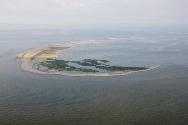
Aerial photograph looking southwest along Breton Island, Louisiana, taken July 2013
Aerial photograph looking southwest along Breton Island, Louisiana, taken July 2013

An HVO geologist walks along the summit trail, with Mauna Kea in the background.
An HVO geologist walks along the summit trail, with Mauna Kea in the background.

View of Channel Islands National Park from a Fall 2018 aerial photographic survey.
The Seabird Studies Team at the USGS Western Ecological Research Center is conducting aerial photographic surveys of the ocean off central and southern California to create comprehensive maps of seabird and marine mammal distributions.

GLSC’s Aaron DeVries and Mckenzie Smith, left, discuss innovative controls for invasive Phragmites australis in GLSC’s greenhouse facility.
GLSC’s Aaron DeVries and Mckenzie Smith, left, discuss innovative controls for invasive Phragmites australis in GLSC’s greenhouse facility.

Northeast Region Photo Contest Winner | November 2018 | Honorable Mention
Laurel formation in Washington East quad examined by Wayne Newell
Northeast Region Photo Contest Winner | November 2018 | Honorable Mention
Laurel formation in Washington East quad examined by Wayne Newell

Photo Contest Winner | March 2020 | Honorable Mention 1
Critical mineral - tungsten
Photo Contest Winner | March 2020 | Honorable Mention 1
Critical mineral - tungsten

Wave-tide gauge, pictured here on a coral reef amongst sea rods, brain corals, and sea fans, installed off Isla Verde in San Juan, Puerto Rico.
Wave-tide gauge, pictured here on a coral reef amongst sea rods, brain corals, and sea fans, installed off Isla Verde in San Juan, Puerto Rico.

HVO geologists made a routine visit to the webcam monitoring Halema‘uma‘u. No changes were observed in the pit, but views were hampered by poor weather and thick fog.
HVO geologists made a routine visit to the webcam monitoring Halema‘uma‘u. No changes were observed in the pit, but views were hampered by poor weather and thick fog.

Digital 3D reconstruction of lake bottom using 10 photo frames taken by the dive camera system. This reconstruction allows us to gain more insight about the lake bottom since elevation has been added to the photographs.
Digital 3D reconstruction of lake bottom using 10 photo frames taken by the dive camera system. This reconstruction allows us to gain more insight about the lake bottom since elevation has been added to the photographs.

Digital 3D reconstruction of lake bottom using 50 photo frames taken by the dive camera system. This example shows an arc since the sampling transect is a circle. This reconstruction allows us to gain more insight about the lake bottom since elevation has been added to the photographs.
Digital 3D reconstruction of lake bottom using 50 photo frames taken by the dive camera system. This example shows an arc since the sampling transect is a circle. This reconstruction allows us to gain more insight about the lake bottom since elevation has been added to the photographs.

Northeast Region Photo Contest Winner | June 2019 | Where We Work
Getting ready to begin an Acoustic Doppler Current Profiler (ADCP) boat measurement at 01457500 Delaware River at Riegelsville, NJ
Northeast Region Photo Contest Winner | June 2019 | Where We Work
Getting ready to begin an Acoustic Doppler Current Profiler (ADCP) boat measurement at 01457500 Delaware River at Riegelsville, NJ

Drone footage of Whiskeytown National Recreation area in Northern California in October 2018, captured by drone pilot and USGS WERC ecologist Chase Freeman.
Drone footage of Whiskeytown National Recreation area in Northern California in October 2018, captured by drone pilot and USGS WERC ecologist Chase Freeman.

Endicott Island, and artificial island built in 1987 by Alaska Interstate Construction and is used by BP and Hilcorp Alaska for petroleum production.
Endicott Island, and artificial island built in 1987 by Alaska Interstate Construction and is used by BP and Hilcorp Alaska for petroleum production.

USGS/EROS Physical Scientist Dean Gesch and USGS/EROS CoNED Applications Project Chief Jeff Danielson discuss the Coastal National Elevation Database (CoNED), its acquisition and its uses.
USGS/EROS Physical Scientist Dean Gesch and USGS/EROS CoNED Applications Project Chief Jeff Danielson discuss the Coastal National Elevation Database (CoNED), its acquisition and its uses.

USGS/EROS Physical Scientist Dean Gesch and USGS/EROS CoNED Applications Project Chief Jeff Danielson discuss different remote sensing methods they used to create topobathemetric elevation models of the Majuro Atoll.
USGS/EROS Physical Scientist Dean Gesch and USGS/EROS CoNED Applications Project Chief Jeff Danielson discuss different remote sensing methods they used to create topobathemetric elevation models of the Majuro Atoll.

Map showing the minimum area covered by volcanic ash from eruptions of Valles Ca
Map showing the minimum area covered by volcanic ash from eruptions of Valles Ca

HVO staff visited the summit of Mauna Loa on foot to repair the webcam. The weather was perfectly clear, and views of the caldera floor showed nothing unusual.
HVO staff visited the summit of Mauna Loa on foot to repair the webcam. The weather was perfectly clear, and views of the caldera floor showed nothing unusual.

Serapeum, a Roman Marketplace in Pozzuoli, Italy, records deformation of Campi Flegrei caldera over two millennia. It was built above sea level about 2000 years ago, but mollusk borings on the large marble columns indicate that it subsided by 7 meters (23 feet) below sea level before being uplifted above sea level once more in the past several hundred years.
Serapeum, a Roman Marketplace in Pozzuoli, Italy, records deformation of Campi Flegrei caldera over two millennia. It was built above sea level about 2000 years ago, but mollusk borings on the large marble columns indicate that it subsided by 7 meters (23 feet) below sea level before being uplifted above sea level once more in the past several hundred years.