
Gradients of N deposition, S deposition, mean annual temperature, and mean annual precipitation across the conterminous U.S. Panels are the a) mean total N deposition from 2000–2012, b) mean total S deposition from 2000–2012, c) mean annual temperature from 2000–2014, and d) mean annual precipitation form 2000–2014.
All Multimedia
Access all multimedia to include images, video, audio, webcams, before-after imagery, and more. Filter and explore with filtering options to refine search.
Filter Total Items: 24926

Figure 1, Horn, et al. (2018)
Gradients of N deposition, S deposition, mean annual temperature, and mean annual precipitation across the conterminous U.S. Panels are the a) mean total N deposition from 2000–2012, b) mean total S deposition from 2000–2012, c) mean annual temperature from 2000–2014, and d) mean annual precipitation form 2000–2014.

Maps displaying the stages of evolution of the more recent cycle of volcanism as
Maps displaying the stages of evolution of the more recent cycle of volcanism asMaps displaying the stages of evolution of the more recent cycle of volcanism associated with Yellowstone Caldera. From Finn and Morgan, 2002 (High-resolution aeromagnetic mapping of volcanic terrain, Yellowstone National Park).

Juga sp. snails
Juga sp. snails, the molluscan intermediate host for Nanophyetus salmincola, populate the bottom of a stream bed in a south Puget Sound watershed.
Juga sp. snails, the molluscan intermediate host for Nanophyetus salmincola, populate the bottom of a stream bed in a south Puget Sound watershed.

A center pivot is used for circular transects
A diver is holding onto a pole which is used as a pivot point. A line can be seen that a diver attachs to a camera for running circular transects. Image taken in Lake Michigan near South Manitou Island.
A diver is holding onto a pole which is used as a pivot point. A line can be seen that a diver attachs to a camera for running circular transects. Image taken in Lake Michigan near South Manitou Island.

A Circular Transect in Lake Ontario
Two SCUBA divers, one at the center pivot (on the left), the other running an integrated camera and scooter (right) run a circular transect in Lake Ontario
Two SCUBA divers, one at the center pivot (on the left), the other running an integrated camera and scooter (right) run a circular transect in Lake Ontario
A crayfish in our sample area
A diver points at a small crayfish near a pivot point used for circular transects in Lake Ontario.
A diver points at a small crayfish near a pivot point used for circular transects in Lake Ontario.

A Smallmouth Bass in Lake Ontario
A smallmouth bass swims near a diver in Lake Ontario.
A smallmouth bass swims near a diver in Lake Ontario.

Deploying Underwater Camera in Lake Michigan
USGS personnel: Sam Pecoraro (left), Tanner Kenney (middle), and Scott Dwyer (right; in the water) deploying an underwater camera in Lake Michigan near South Manitou Island.
USGS personnel: Sam Pecoraro (left), Tanner Kenney (middle), and Scott Dwyer (right; in the water) deploying an underwater camera in Lake Michigan near South Manitou Island.

Hurricane Michael cut deep into Panhandle dunes
A deeply eroded sand dune on the beach at Cape San Blas shows Hurricane Michael's impact on parts of the Florida Panhandle shoreline.
A deeply eroded sand dune on the beach at Cape San Blas shows Hurricane Michael's impact on parts of the Florida Panhandle shoreline.

Image of the Week - Cottonwood Fire
October 16, 2018, marks the two-year anniversary of the Cottonwood Fire in western South Dakota. The fire consumed a large swath of grassland near the community of Wall and just north of Badlands National Park.
October 16, 2018, marks the two-year anniversary of the Cottonwood Fire in western South Dakota. The fire consumed a large swath of grassland near the community of Wall and just north of Badlands National Park.

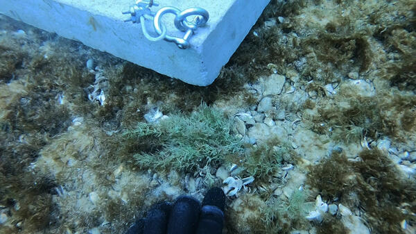
Lake Michigan lake bottom and the corner of a pivot point
Lake Michigan lake bottom and the corner of a pivot pointLake Michigan lake-bottom near South Manitou Island. Visible is part of a diver's hand and the corner of a anchor point used for circular transects.
Lake Michigan lake bottom and the corner of a pivot point
Lake Michigan lake bottom and the corner of a pivot pointLake Michigan lake-bottom near South Manitou Island. Visible is part of a diver's hand and the corner of a anchor point used for circular transects.

panoramic view, Hawai‘i Volcanoes National Park's Crater Rim Drive
panoramic view, Hawai‘i Volcanoes National Park's Crater Rim DriveIn this panoramic view, Hawai‘i Volcanoes National Park's Crater Rim Drive (left foreground) disappears into the enormous void created by the collapse of Halema‘uma‘u and portions of the Kīlauea caldera floor during the dramatic events at the summit of the volcano in May-August 2018.

Preparing to Collect Data in Lake Ontario
A camera integrated wth a dive scooter is lowered into the water in Lake Ontario
A camera integrated wth a dive scooter is lowered into the water in Lake Ontario

The Diver's Point of View
This is the view a SCUBA diver has using our integrated camera and scooter instrument in Lake Huron.
This is the view a SCUBA diver has using our integrated camera and scooter instrument in Lake Huron.

Color-shaded topographic relief map of the Yellowstone Plateau-Snake River Plain
Color-shaded topographic relief map of the Yellowstone Plateau-Snake River PlainColor-shaded topographic relief map of the Yellowstone Plateau-Snake River Plain volcanic province showing the track of the Yellowstone hot spot. Figure by Ken Pierce and Lisa Morgan.

Hiking into the Owyhee Canyonlands to install a crest stage gage
Hiking into the Owyhee Canyonlands to install a crest stage gageBureau of Land Management wilderness ranger Evan Worthington leads U.S. Geological Survey hydrographers John Carricaburu and Russ Miller over a canyon rim and down to Deep Creek to install a crest stage gage. USGS scientists will incorporte data from the gage into an evaluation of streamflow in the Owyhee Canyonlands.

Hurricane Michael destroyed many houses on Cape San Blas, Florida
Hurricane Michael destroyed many houses on Cape San Blas, FloridaA beach house in Cape San Blas, Florida destroyed by Hurricane Michael, which struck the Florida Panhandle as a Category Four storm Oct. 10, 2018.
Hurricane Michael destroyed many houses on Cape San Blas, Florida
Hurricane Michael destroyed many houses on Cape San Blas, FloridaA beach house in Cape San Blas, Florida destroyed by Hurricane Michael, which struck the Florida Panhandle as a Category Four storm Oct. 10, 2018.

Economic benefits of marshes
Photo showing floating cages for oyster farming in a marsh creek exposed at low tide.
Photo showing floating cages for oyster farming in a marsh creek exposed at low tide.

Saltmarsh vegetation
Photo showing different species of salt tolerant plants near a saltmarsh.
Photo showing different species of salt tolerant plants near a saltmarsh.

School of juvenile fish in water next to marsh vegetation
School of juvenile fish in water next to marsh vegetationPhoto showing school of juvenile fish in water next to marsh vegetation.
School of juvenile fish in water next to marsh vegetation
School of juvenile fish in water next to marsh vegetationPhoto showing school of juvenile fish in water next to marsh vegetation.

Social benefits of marshes
Photo of a boardwalk over a saltmarsh creek showing people.
Photo of a boardwalk over a saltmarsh creek showing people.