
USGS staffer Matthew Jennings collecting water quality samples on the lower Niagara River for the Great Lakes Restoration Initiative (GLRI) project. Photo by John Wernly (Public domain)
Images
Explore our planet through photography and imagery, including climate change and water all the way back to the 1800s when the USGS was surveying the country by horse and buggy.
Filter Total Items: 21357

Niagara River Water Quality Sample 2019
USGS staffer Matthew Jennings collecting water quality samples on the lower Niagara River for the Great Lakes Restoration Initiative (GLRI) project. Photo by John Wernly (Public domain)

天然水循环, The Water Cycle, Chinese
什么是水循环?
什么是水循环?回答这个问题非常容易 ---水循环通常也被称为"水分循环"或"水文循环",是指水在地球上、地球中以及地球上空的存在及运动情况。地球的水处于不停地运动中,并且不停地变换着存在形式,从液体变成水蒸气再变成冰,然后再循环往复。水循环已经持续了几十亿年,地球上的所有生命都依赖于水循环。如果没有水循环,地球将会是一个毫无生气的地方。
什么是水循环?
什么是水循环?回答这个问题非常容易 ---水循环通常也被称为"水分循环"或"水文循环",是指水在地球上、地球中以及地球上空的存在及运动情况。地球的水处于不停地运动中,并且不停地变换着存在形式,从液体变成水蒸气再变成冰,然后再循环往复。水循环已经持续了几十亿年,地球上的所有生命都依赖于水循环。如果没有水循环,地球将会是一个毫无生气的地方。

El Ciclo Natural del Agua - The Natural Water Cycle, Spanish
El Ciclo Natural del Agua - The Natural Water Cycle, SpanishEl Ciclo del Agua


Puhimau thermal area has the largest naturally occurring population of the endan
Puhimau thermal area has the largest naturally occurring population of the endanPuhimau thermal area has the largest naturally occurring population of the endangered plant, Portulaca sclerocarpa (marked by the blue flag in the photo), and is the site of National Park Service restoration efforts for this species.

Sierra marten caught on camera
This Sierra Marten was caught on wildlife camera in October. The camera was set up to study animal movement under a new road crossing structure known as the “toad road” in Sierra National Forest. The Sierra marten (Martes caurina sierra) is a mammal in the weasel family about the size of a house cat.
This Sierra Marten was caught on wildlife camera in October. The camera was set up to study animal movement under a new road crossing structure known as the “toad road” in Sierra National Forest. The Sierra marten (Martes caurina sierra) is a mammal in the weasel family about the size of a house cat.

USGS stream gage 10242000 Coal Creek near Cedar City, Utah
USGS stream gage 10242000 Coal Creek near Cedar City, UtahFall time descends on Southwest Utah. The changing fall leaves coupled with blue skies and red rock backdrop make for a beautiful morning for a discharge measurement at the Coal Creek near Cedar City, Utah stream gage 10242000.

Boise River Watershed Watch, 2019
U.S. Geological Survey hydrologist Tyler King helps a citizen volunteer test a water sample for dissolved oxygen as part of the 2019 Watershed Watch in the lower Boise River watershed of southwestern Idaho. Watershed Watch is an annual citizen science event sponsored by the City of Boise. The USGS is an event co-sponsor.
U.S. Geological Survey hydrologist Tyler King helps a citizen volunteer test a water sample for dissolved oxygen as part of the 2019 Watershed Watch in the lower Boise River watershed of southwestern Idaho. Watershed Watch is an annual citizen science event sponsored by the City of Boise. The USGS is an event co-sponsor.

Removal of sediment-filled core liner
USGS scientists Brandon Nasr, Jenna Hill, Nora Nieminski, and Jenny McKee removing a sediment-filled core liner from the jumbo piston core barrel with the picturesque northern California coastline in the background.
USGS scientists Brandon Nasr, Jenna Hill, Nora Nieminski, and Jenny McKee removing a sediment-filled core liner from the jumbo piston core barrel with the picturesque northern California coastline in the background.

Chirp sub-bottom profiler ready for deployment
UCSC student Travis Alonghi and USGS scientist Danny Brothers deploying the Chirp sub-bottom profiler at sunset from M/V Bold Horizon.
UCSC student Travis Alonghi and USGS scientist Danny Brothers deploying the Chirp sub-bottom profiler at sunset from M/V Bold Horizon.

Cross Shore Array Deployment at the FRF
The USGS Coastal and Estuarine Dynamics Group will be deploying a cross shore array at Pea Island, various intruments will be connected to the poles to measure oceanographic conditions
The USGS Coastal and Estuarine Dynamics Group will be deploying a cross shore array at Pea Island, various intruments will be connected to the poles to measure oceanographic conditions

Field trip guide to Mount St. Helens, Washington—Recent and ancient volcan
Field trip guide to Mount St. Helens, Washington—Recent and ancient volcanThe Field trip guide to Mount St. Helens, Washington—Recent and ancient volcaniclastic processes and deposits is available in the USGS Publications Warehouse, at https://doi.org/10.3133/sir20175022E.

Geophysicist Sarah Conway, USGS HVO geophysicist
Geophysicist Sarah Conway, a member of the USGS Hawaiian Volcano Observatory's deformation team, readies a temporary GPS station during a campaign survey of benchmarks on Kīlauea Volcano to monitor changes in the ground surface.
Geophysicist Sarah Conway, a member of the USGS Hawaiian Volcano Observatory's deformation team, readies a temporary GPS station during a campaign survey of benchmarks on Kīlauea Volcano to monitor changes in the ground surface.

Adult Sage Thrasher waiting to deliver food to its nestlings.
Adult Sage Thrasher waiting to deliver food to its nestlings.Adult Sage Thrasher waiting to deliver food to its nestlings.
Adult Sage Thrasher waiting to deliver food to its nestlings.
Adult Sage Thrasher waiting to deliver food to its nestlings.Adult Sage Thrasher waiting to deliver food to its nestlings.

Capping and securing a trigger core
USGS scientists Nora Nieminski, Jenna Hill, and Brandon Nasr working to cap and secure a trigger core on deck. Trigger cores can provide important information about seafloor sediments just below the seafloor
USGS scientists Nora Nieminski, Jenna Hill, and Brandon Nasr working to cap and secure a trigger core on deck. Trigger cores can provide important information about seafloor sediments just below the seafloor

Lowering Chirp from R/V Bold Horizon
The crew of research vessel Bold Horizon with USGS science crew prepare to launch the Chirp sub-bottom profiler off the west coast near northern California and southern Oregon.
The crew of research vessel Bold Horizon with USGS science crew prepare to launch the Chirp sub-bottom profiler off the west coast near northern California and southern Oregon.
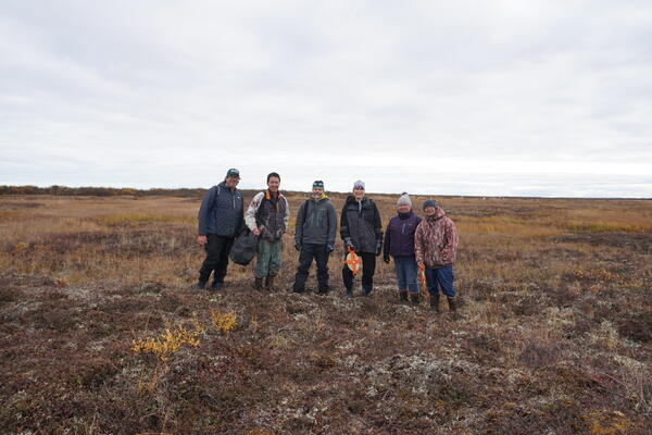
Active Layer Network, Alaska.
From left to right: Ryan Toohey, Bernard TKTKTK, Jeremy Littell (AK CASC Lead Scientist), Malinda Chase (AK CASC Tribal Liaison), Philomena Keyes, and Victor Tonuchuk, Jr. at the Active Layer Network site in Kotlik, Alaska.
From left to right: Ryan Toohey, Bernard TKTKTK, Jeremy Littell (AK CASC Lead Scientist), Malinda Chase (AK CASC Tribal Liaison), Philomena Keyes, and Victor Tonuchuk, Jr. at the Active Layer Network site in Kotlik, Alaska.

Core recovery
USGS scientists Pete Dal Ferro and Jenny McKee securing a recently collected jumbo piston core (JPC) on the back deck of M/V Bold Horizon for preliminary core processing.
USGS scientists Pete Dal Ferro and Jenny McKee securing a recently collected jumbo piston core (JPC) on the back deck of M/V Bold Horizon for preliminary core processing.

Dale Griffin is interviewed about dust and harmful algal blooms
Dale Griffin is interviewed about dust and harmful algal bloomsDale Griffin of the St. Petersburg Coastal and Marine Science Center is interviewed about the links between Saharan dust and harmful algal blooms off the coast of Florida.
Dale Griffin is interviewed about dust and harmful algal blooms
Dale Griffin is interviewed about dust and harmful algal bloomsDale Griffin of the St. Petersburg Coastal and Marine Science Center is interviewed about the links between Saharan dust and harmful algal blooms off the coast of Florida.

Hooray for sediment cores!
Dr. Nora Nieminski is a research geologist and Mendenhall Fellow at the USGS Pacific Coastal and Marine Science Center in Santa Cruz, California. She is pictured here, on board Marine Vessel Bold Horizon, with a piston core sample collected from the southern Cascadia subduction zone offshore of northern California/southern Oregon.
Dr. Nora Nieminski is a research geologist and Mendenhall Fellow at the USGS Pacific Coastal and Marine Science Center in Santa Cruz, California. She is pictured here, on board Marine Vessel Bold Horizon, with a piston core sample collected from the southern Cascadia subduction zone offshore of northern California/southern Oregon.

Jumbo piston corer with mud from the seafloor
After recovery, the jumbo piston corer sits on the deck of research vessel Bold Horizon in its launch and recovery system. This muddy collar is removed to reveal the removable length of the core, which sits within a stiff plastic tube inside the metal tube.
After recovery, the jumbo piston corer sits on the deck of research vessel Bold Horizon in its launch and recovery system. This muddy collar is removed to reveal the removable length of the core, which sits within a stiff plastic tube inside the metal tube.