
Abnormally high spring rainfall and subsequent flooding in the Midwest in 2019 had a season-long impact on cropland production.
Images
Total: 0
Advanced Search
Choose search keyword and/or remove with "X" in search keyword button below.
Filters
Total: 0
Total: 0
Advanced Search
Choose search keyword and/or remove with "X" in search keyword button below.
Filters
Settings
Total: 0
Explore our planet through photography and imagery, including climate change and water all the way back to the 1800s when the USGS was surveying the country by horse and buggy.
Filter Total Items: 21608

South Dakota's Unplanted Acres of 2019
Abnormally high spring rainfall and subsequent flooding in the Midwest in 2019 had a season-long impact on cropland production.

Hydrologic Technician measuring discharge. South Cascade Glacier, WA.
Hydrologic Technician Dan Restivo of the USGS Washington Water Science Center admires the view while measuring discharge at the base of the South Cascade Glacier station 12181090 South Cascade Middle Tarn near Marblemount, WA.
Hydrologic Technician Dan Restivo of the USGS Washington Water Science Center admires the view while measuring discharge at the base of the South Cascade Glacier station 12181090 South Cascade Middle Tarn near Marblemount, WA.

Red fox kits on St. Matthew Island, Alaska
Red fox kits on St. Matthew Island, Alaska
Red fox kits on St. Matthew Island, Alaska

Canada goose (Branta canadensis), Anchorage, AK
Canada goose (Branta canadensis), Anchorage, AK
Canada goose (Branta canadensis), Anchorage, AK

Bandera water supply tower
Southwest-oriented view of the Bandera water supply tower near the Bandera County Courthouse, Bandera, Texas, December 2018 (photograph by Frank L. Engel, U.S. Geological Survey).
SIR 2019-5067
Southwest-oriented view of the Bandera water supply tower near the Bandera County Courthouse, Bandera, Texas, December 2018 (photograph by Frank L. Engel, U.S. Geological Survey).
SIR 2019-5067
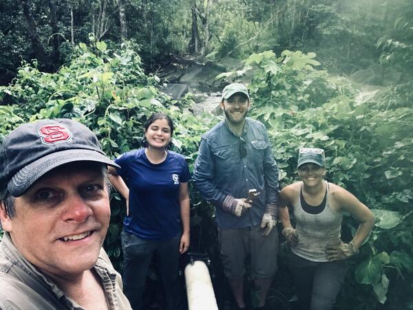
Dr. Tom Kwak, Dr. Gus Engman, Ámbar Torres Molinari, and Bonnie Myers
Dr. Tom Kwak, Dr. Gus Engman, Ámbar Torres Molinari, and Bonnie Myers working on rebuilding artificial streams to run experiments on native and non-native fish responses to extreme climate events.
Dr. Tom Kwak, Dr. Gus Engman, Ámbar Torres Molinari, and Bonnie Myers working on rebuilding artificial streams to run experiments on native and non-native fish responses to extreme climate events.
Medina River near State Route 16 in Bandera
West-oriented view of the Medina River looking upstream near State Route 16 in Bandera, Texas, December 2018 (photograph by Frank L. Engel, U.S. Geological Survey).
SIR 2019-5067
West-oriented view of the Medina River looking upstream near State Route 16 in Bandera, Texas, December 2018 (photograph by Frank L. Engel, U.S. Geological Survey).
SIR 2019-5067

Lesser Snow Geese are herded into a pen to await banding
Lesser Snow Geese are captured using a helicopter to herd them into large pens to await banding.
Lesser Snow Geese are captured using a helicopter to herd them into large pens to await banding.

A Black-legged Kittiwake with two chicks at Gull Island, Alaska
A Black-legged Kittiwake with two chicks at Gull Island, Alaska.
A Black-legged Kittiwake with two chicks at Gull Island, Alaska.

A Common Murre on the water near its colony in Kachemak Bay, Alaska
Northern Fulmars, Black-legged Kittiwakes, and Common Murres have all been tested for and contained harmful algal bloom (HAB) toxins in Alaska. Since 2015, the USGS has worked with a variety of stakeholders to develop testing methods and research projects to better understand the geographic extent, timing and impacts of algal toxins in Alaska marine ecosystems.
Northern Fulmars, Black-legged Kittiwakes, and Common Murres have all been tested for and contained harmful algal bloom (HAB) toxins in Alaska. Since 2015, the USGS has worked with a variety of stakeholders to develop testing methods and research projects to better understand the geographic extent, timing and impacts of algal toxins in Alaska marine ecosystems.

Halema‘uma‘u taken during a helicopter lidar survey on July 25, 2019
Telephoto views of water in the bottom of Halema‘uma‘u taken during a helicopter lidar survey on July 25, 2019 (left), when the pond was first observed, and a USGS overflight on August 1, 2019 (right). The pond grew slightly in size and depth between the two dates; an "X" marks the same rock in both photos for comparison.
Telephoto views of water in the bottom of Halema‘uma‘u taken during a helicopter lidar survey on July 25, 2019 (left), when the pond was first observed, and a USGS overflight on August 1, 2019 (right). The pond grew slightly in size and depth between the two dates; an "X" marks the same rock in both photos for comparison.

Lesser Snow Geese in a pen awaiting banding
Lesser Snow Geese are captured using a helicopter to herd them into large pens to await banding.
Lesser Snow Geese are captured using a helicopter to herd them into large pens to await banding.

USGS field biologist Andrea Mott displays a Lesser Snow Goose
USGS field biologist Andrea Mott displays a recently marked Lesser Snow Goose.
USGS field biologist Andrea Mott displays a recently marked Lesser Snow Goose.

Collecting Field Parameters During the 2019 Well Inventory
USGS hydrologic technician collecting field parameters during the 2019 well inventory at a farm and ranch in the north central portion of the Fort Peck reservation.
USGS hydrologic technician collecting field parameters during the 2019 well inventory at a farm and ranch in the north central portion of the Fort Peck reservation.

Scientist with plankton sample to test for harmful algal bloom toxins
USGS Scientist Sarah Schoen with a plankton sample to test for harmful algal bloom toxins in Cook Inlet, Alaska.
USGS Scientist Sarah Schoen with a plankton sample to test for harmful algal bloom toxins in Cook Inlet, Alaska.

Supporting Tribal Seed Sovereignty
USGS Restoration Assessment and Monitoring Program for the Southwest (RAMPS) is helping to build capacity in ecosystem restoration on the Navajo Nation with a series of projects in collaboration with Navajo Nation Department of Natural Hertiage, Dine Native Plant Program, and the Native-led non-profit Tolani Lake Enterprises.
USGS Restoration Assessment and Monitoring Program for the Southwest (RAMPS) is helping to build capacity in ecosystem restoration on the Navajo Nation with a series of projects in collaboration with Navajo Nation Department of Natural Hertiage, Dine Native Plant Program, and the Native-led non-profit Tolani Lake Enterprises.

USGS surveys for piping plovers
Two USGS research technicians walk across a sparsely vegetated sandbar towards the Missouri River while surveying for piping plovers.
Two USGS research technicians walk across a sparsely vegetated sandbar towards the Missouri River while surveying for piping plovers.

Adaptive Management and Monitoring of Pyramid Lake, Nevada UT
Pyramid Lake, Nevada, is one of the last remaining strongholds for lacustrine Lahontan cutthroat trout; almost all other large lake populations have undergone population declines or extirpation as a result of habitat degradation, overharvest, and water diversions, all compounded by the stocking of nonnative species.
Pyramid Lake, Nevada, is one of the last remaining strongholds for lacustrine Lahontan cutthroat trout; almost all other large lake populations have undergone population declines or extirpation as a result of habitat degradation, overharvest, and water diversions, all compounded by the stocking of nonnative species.

Gearing up boat at the Alsek River, Alaska
Preparing the boat for isokinetic water sampling using the equal discharge increment method on the Alsek River.
Preparing the boat for isokinetic water sampling using the equal discharge increment method on the Alsek River.

Abandoned Farm on the Northwest Corner of the Fort Peck Reservation
Abandoned Farm on the Northwest Corner of the Fort Peck Reservation
Abandoned Farm on the Northwest Corner of the Fort Peck Reservation

Fallow Field (Left) and Dryland Wheat (Right) near Larslan, MT
Fallow field on the left and dryland wheat on the right, northwestern corner of the Fort Peck Reservation (near Larslan, MT)
Fallow field on the left and dryland wheat on the right, northwestern corner of the Fort Peck Reservation (near Larslan, MT)