



The Research Vessel Peterson Underway in San Francisco Bay.
Images
Explore our planet through photography and imagery, including climate change and water all the way back to the 1800s when the USGS was surveying the country by horse and buggy.
Filter Total Items: 21394

R/V Peterson Underway in San Francisco Bay
The Research Vessel Peterson Underway in San Francisco Bay.
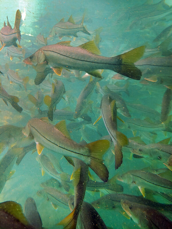
Subtropical snook gather at a warm Florida springhead in winter
Subtropical snook gather at a warm Florida springhead in winterWinter temperature extremes control the distributions of subtropical fishes. Common snook (Centropomus undecimalis), aggregate at a spring in northern Florida during winter. Snook are warm saltwater game fish, common in Florida, that have been moving further northward as extreme cold spells become less frequent and less intense.
Subtropical snook gather at a warm Florida springhead in winter
Subtropical snook gather at a warm Florida springhead in winterWinter temperature extremes control the distributions of subtropical fishes. Common snook (Centropomus undecimalis), aggregate at a spring in northern Florida during winter. Snook are warm saltwater game fish, common in Florida, that have been moving further northward as extreme cold spells become less frequent and less intense.

View of lava lake in Halema‘uma‘u - Kīlauea, March 15, 2021
View of lava lake in Halema‘uma‘u - Kīlauea, March 15, 2021View of the lava lake from the south rim of Halema‘uma‘u, at the summit of Kīlauea, looking north. The western (left) portion of the lava lake remains active, with small scale crustal foundering events. Lava enters the lake at two sources approximately 20 to 30 meters (65 to 100 ft) apart at the base of the western vent spatter cone.
View of lava lake in Halema‘uma‘u - Kīlauea, March 15, 2021
View of lava lake in Halema‘uma‘u - Kīlauea, March 15, 2021View of the lava lake from the south rim of Halema‘uma‘u, at the summit of Kīlauea, looking north. The western (left) portion of the lava lake remains active, with small scale crustal foundering events. Lava enters the lake at two sources approximately 20 to 30 meters (65 to 100 ft) apart at the base of the western vent spatter cone.

Agassiz Glacier in 1913 and 2007
Agassiz Glacier: 8/5/1913 WC Alden, USGS Photographic Library - 8/24/2007, D Fagre, USGS
View the full collection at USGS Photographic Library
Agassiz Glacier: 8/5/1913 WC Alden, USGS Photographic Library - 8/24/2007, D Fagre, USGS
View the full collection at USGS Photographic Library

March 12, 2021—Kīlauea summit eruption contour map
March 12, 2021—Kīlauea summit eruption contour mapThis map of Halema‘uma‘u at the summit of Kīlauea shows 20 m (66 ft) contour lines (dark gray) that mark locations of equal elevation above sea level (asl). The map shows that the lava lake has filled 221 m (725 ft) of the crater, to an elevation of 737 m (2418 ft) asl since the eruption began on December 20, 2020.
March 12, 2021—Kīlauea summit eruption contour map
March 12, 2021—Kīlauea summit eruption contour mapThis map of Halema‘uma‘u at the summit of Kīlauea shows 20 m (66 ft) contour lines (dark gray) that mark locations of equal elevation above sea level (asl). The map shows that the lava lake has filled 221 m (725 ft) of the crater, to an elevation of 737 m (2418 ft) asl since the eruption began on December 20, 2020.

Boulder Ice Cave Glacier 1932 and 1988
Boulder Glacier Ice Cave: 1932, TJ Hileman, GNP Archives – 1988, J DeSanto, U of M Library
This photo pair inspired the USGS to document glacier and landscape change using oblique photography.
Boulder Glacier Ice Cave: 1932, TJ Hileman, GNP Archives – 1988, J DeSanto, U of M Library
This photo pair inspired the USGS to document glacier and landscape change using oblique photography.

Chaney Glacier 1911 and 2005
Chaney Glacier: 1911, MR Campbell, USGS Photographic Library – 8/19/2005 Karen Milone, USGS
View the full collection at USGS Photographic Library
Chaney Glacier: 1911, MR Campbell, USGS Photographic Library – 8/19/2005 Karen Milone, USGS
View the full collection at USGS Photographic Library

Gamma detectors at the St. Petersburg Coastal & Marine Science Center
Gamma detectors at the St. Petersburg Coastal & Marine Science CenterRadioactive isotopes are common in nature and emit particles that can be detected, quantified, and used to characterize environmental processes.
Gamma detectors at the St. Petersburg Coastal & Marine Science Center
Gamma detectors at the St. Petersburg Coastal & Marine Science CenterRadioactive isotopes are common in nature and emit particles that can be detected, quantified, and used to characterize environmental processes.

March 11, 2021 - Halema‘uma‘u lava lake
View of the lava lake from the southern rim of Halema‘uma‘u, at the summit of Kīlauea, looking north. The western portion of the lava lake remains active, with small scale crustal foundering events. The white steam from the crater walls is more pronounced due to the heavy rain of the last couple of days.
View of the lava lake from the southern rim of Halema‘uma‘u, at the summit of Kīlauea, looking north. The western portion of the lava lake remains active, with small scale crustal foundering events. The white steam from the crater walls is more pronounced due to the heavy rain of the last couple of days.

Mauna Loa eruption response times over the past 200 years
Mauna Loa eruption response times over the past 200 yearsThis map shows the response time people can expect based on Mauna Loa eruptions over the past 200 years. Different sectors around Mauna Loa are colored according to how quickly lava flows can reach populated areas. The warmer the color, the more quickly the flows travel.
Mauna Loa eruption response times over the past 200 years
Mauna Loa eruption response times over the past 200 yearsThis map shows the response time people can expect based on Mauna Loa eruptions over the past 200 years. Different sectors around Mauna Loa are colored according to how quickly lava flows can reach populated areas. The warmer the color, the more quickly the flows travel.

Repeat photo of Harrison Glacier (1913, 2009)
Repeat photo of Harrison Glacier. 8/20/1913 by WC Alden, USGS Photographic Library, 7/30/2009 by Ralph Thornton, USGS.
Repeat photo of Harrison Glacier. 8/20/1913 by WC Alden, USGS Photographic Library, 7/30/2009 by Ralph Thornton, USGS.

Shepard Glacier
Karen Holzer and Lisa McKeon rephotograph Shepard Glacier from the slope of Pyramid Peak, Glacier National Park. 1998 USGS photo.
Karen Holzer and Lisa McKeon rephotograph Shepard Glacier from the slope of Pyramid Peak, Glacier National Park. 1998 USGS photo.

Western fissure area in Halema‘uma‘u, Kīlauea summit (3/11/2021)
Western fissure area in Halema‘uma‘u, Kīlauea summit (3/11/2021)View looking to the northwest of western fissure area of Halema‘uma‘u lava lake at the Kīlauea summit on March 11, 2021. There is a small incandescent opening at the top of the main (southern) west vent spatter cone (middle-left), and a few smaller incandescent openings at the top of the northern west vent spatter cone (right of the main cone).
Western fissure area in Halema‘uma‘u, Kīlauea summit (3/11/2021)
Western fissure area in Halema‘uma‘u, Kīlauea summit (3/11/2021)View looking to the northwest of western fissure area of Halema‘uma‘u lava lake at the Kīlauea summit on March 11, 2021. There is a small incandescent opening at the top of the main (southern) west vent spatter cone (middle-left), and a few smaller incandescent openings at the top of the northern west vent spatter cone (right of the main cone).

Repeat photo of Grinnell Glacier (1910, 2016)
Grinnell Glacier in 1910 (Elrod photo, U of M Collection) and 2016 (McKeon photo, USGS). Retreat resulted in glacier fragmentation, so the 2016 scene shows both Grinnell Glacier, hugging the base of the cliff, and The Salamander Glacier, perched above, along the right edge of the photograph.
Grinnell Glacier in 1910 (Elrod photo, U of M Collection) and 2016 (McKeon photo, USGS). Retreat resulted in glacier fragmentation, so the 2016 scene shows both Grinnell Glacier, hugging the base of the cliff, and The Salamander Glacier, perched above, along the right edge of the photograph.

Shepard Glacier in 1913 and 2005
Shepard Glacier: 9/6/1913, WC Alden, USGS Photo Library – 8/21/2005, B. Reardon, USGS
Shepard Glacier: 9/6/1913, WC Alden, USGS Photo Library – 8/21/2005, B. Reardon, USGS

Sperry Glacier in about 1930 and 2008
Sperry Glacier: circa 1930, MJ Elrod, U of M Library – 9/17/2008, L McKeon, USGS
Repeating this photo from the same photo point was impossible since the historic photo was shot from the elevated perspective of the glacier’s surface.
Sperry Glacier: circa 1930, MJ Elrod, U of M Library – 9/17/2008, L McKeon, USGS
Repeating this photo from the same photo point was impossible since the historic photo was shot from the elevated perspective of the glacier’s surface.

Aerial view of northern Pinellas County barrier islands
Aerial view of northern Pinellas County barrier islandsBarrier islands off the coast of northern Pinellas County, Florida including Anclote Key, Three Rooker Island, and the northern tip of Honeymoon Island. These barriers protect a highly populated coastline.
Aerial view of northern Pinellas County barrier islands
Aerial view of northern Pinellas County barrier islandsBarrier islands off the coast of northern Pinellas County, Florida including Anclote Key, Three Rooker Island, and the northern tip of Honeymoon Island. These barriers protect a highly populated coastline.

Grinnell Glacier from 1938 and 2019
Grinnell and The Salamander Glaciers from the summit of Mt. Gould: 1938, TJ Hileman, GNP Archives – 9/4/2019, L McKeon, USGS
Upper Grinnell Lake has formed as the glacier has retreated. The change in height of Grinnell Glacier along the cliff face hints at volume loss during this timespan.
Grinnell and The Salamander Glaciers from the summit of Mt. Gould: 1938, TJ Hileman, GNP Archives – 9/4/2019, L McKeon, USGS
Upper Grinnell Lake has formed as the glacier has retreated. The change in height of Grinnell Glacier along the cliff face hints at volume loss during this timespan.

Jackson Glacier in 1912 and 2009
Jackson Glacier: 1912, MJ Elrod, U of M Library – 9/3/2009, L McKeon, USGS
Trees and vegetation continue to establish themselves at the base of Jackson Glacier as the glacier retreats.
Jackson Glacier: 1912, MJ Elrod, U of M Library – 9/3/2009, L McKeon, USGS
Trees and vegetation continue to establish themselves at the base of Jackson Glacier as the glacier retreats.

Logan and Red Eagle Glaciers in 1914 and 2009
Logan and Red Eagle Glaciers: Aug. 1914, EC Stebinger, USGS Photo Library – 9/2/2009, L McKeon, USGS
These glaciers were once a continuous glacier, but became separate glaciers as retreat progressed.
Logan and Red Eagle Glaciers: Aug. 1914, EC Stebinger, USGS Photo Library – 9/2/2009, L McKeon, USGS
These glaciers were once a continuous glacier, but became separate glaciers as retreat progressed.

Swiftcurrent Glacier in 1910 and 2016
Swiftcurrent Glacier: circa 1910, M. Elod, GNP Archives - 9/27/2016, L McKeon, USGS
During the timespan between these photos, it is evident that Swiftcurrent Glacier has retreated and wildfire has consumed a patch of trees at the base of Swiftcurrent Mountain, the broad, beige slope in the background.
Swiftcurrent Glacier: circa 1910, M. Elod, GNP Archives - 9/27/2016, L McKeon, USGS
During the timespan between these photos, it is evident that Swiftcurrent Glacier has retreated and wildfire has consumed a patch of trees at the base of Swiftcurrent Mountain, the broad, beige slope in the background.