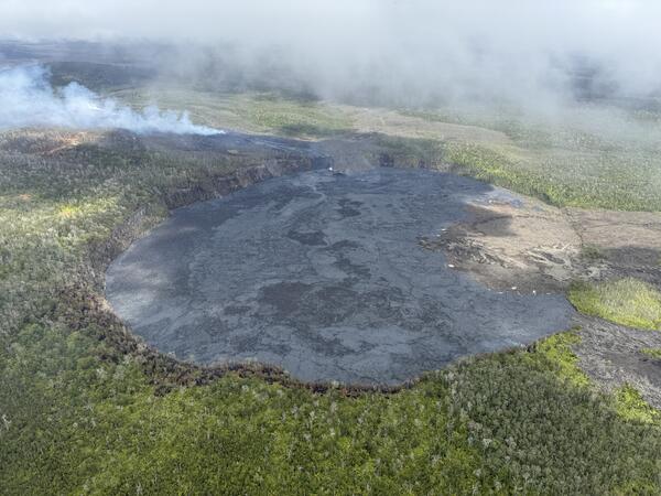
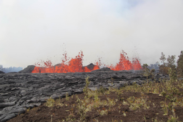
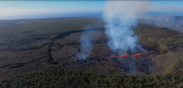
USGS Hawaiian Volcano Observatory geologists conducted an overflight on the morning of Friday, December 27, 2024, of the ongoing Kīlauea summit eruption within Halema‘uma‘u crater.
Videos
Explore a diverse collection of engaging videos showcasing the latest research, discoveries, and educational content from the U.S. Geological Survey. Dive into the fascinating world of geology, hydrology, ecology, and natural hazards as we bring science to life. Stay informed and inspired by our visual storytelling that highlights the vital work of USGS scientists and their impact on the planet.
Subscribe to us
USGS Hawaiian Volcano Observatory geologists conducted an overflight on the morning of Friday, December 27, 2024, of the ongoing Kīlauea summit eruption within Halema‘uma‘u crater.
December 24, 2024 - Video of lava fountains at Kīlauea summit
December 24, 2024 - Video of lava fountains at Kīlauea summitGlowing red lava fountains are continuing to erupt at Kīlauea summit this Christmas Eve. USGS Hawaiian Volcano Observatory scientists monitored the eruption from the caldera rim, measuring the lava fountain heights at approximately 75 meters (246 feet) during an afternoon monitoring fieldshift.
The B2cam captures a live view of Halemaʻumaʻu crater from the east rim and down-dropped block, looking west across Kīlauea summit caldera. On December 23, 2024, it captured the start of another Kīlauea summit eruption. Images taken by the webcam were compiled into this timelapse video that shows lava fountains feeding lava flows across the caldera floor.
The B2cam captures a live view of Halemaʻumaʻu crater from the east rim and down-dropped block, looking west across Kīlauea summit caldera. On December 23, 2024, it captured the start of another Kīlauea summit eruption. Images taken by the webcam were compiled into this timelapse video that shows lava fountains feeding lava flows across the caldera floor.
 Color photograph of lava eruptive and feeding lava flows on crater floor
This video, taken from the west rim of Kaluapele (Kīlauea caldera), in the closed area of Hawaiʻi Volcanoes National Park, shows the new eruption that started this morning at 2:20 a.m. HST. At approximately 4:30 a.m.
This video, taken from the west rim of Kaluapele (Kīlauea caldera), in the closed area of Hawaiʻi Volcanoes National Park, shows the new eruption that started this morning at 2:20 a.m. HST. At approximately 4:30 a.m.
 Color photograph of caldera with fresh lava flows and active eruption
December 23, 2024 - Kīlauea summit eruption overflight
December 23, 2024 - Kīlauea summit eruption overflightThis aerial video, captured during a USGS Hawaiian Volcano Observatory monitoring overflight at approximately 2:30 p.m. HST, shows lava fountaining in the southwest part of Kaluapele (Kīlauea summit caldera). The eruption began today, December 23, 2024, and covered approximately 650 acres of the caldera floor with lava. USGS video by M. Patrick.
 Color photograph of active lava flows
December 23, 2024 - V1cam captures Kīlauea summit eruption onset
December 23, 2024 - V1cam captures Kīlauea summit eruption onsetThe V1cam provides a live view of Kīlauea caldera down-dropped block and Halemaʻumaʻu crater from the northwest rim of the caldera. It captured the Kīlauea summit eruption start on December 23, 2024, and images are compiled into a timelapse sequence here.
 Thumbnail reads: 1 Hour of Earth from Above, Relaxing Landsat Satellite Imagery
1 HOUR Relaxing Satellite Imagery (Sleep Music, Landsat, Concentrate, Meditation)
1 HOUR Relaxing Satellite Imagery (Sleep Music, Landsat, Concentrate, Meditation)Landsat satellites capture images of the Earth’s surface. While the sensors aboard Landsat capture a wide range of scientifically useful wavelengths, this collection reveals natural color imagery in the red, green and blue parts of the visible spectrum, as if viewed by the naked eye from 438 miles above the surface.
 Hydrothermal thermal explosions – more common than you think
Hydrothermal Explosions — more common than you think! (Yellowstone Monthly Update - Dec 2024)
Hydrothermal Explosions — more common than you think! (Yellowstone Monthly Update - Dec 2024)The hydrothermal explosion in Biscuit Basin stole all the headlines. But did you know there was a smaller hydrothermal explosion in Norris Geyser Basin on April 15, 2024? That explosion was detected by a new infrasound sensor installed this past September. Watch to learn more.
 Text: Can these rocks reduce flooding? with an image of Laura Norman and a two men standing on a gabion in the background.
Can these rocks reduce flooding? (English captions)
Can these rocks reduce flooding? (English captions)Creating a binational sponge city in the desert: Flooding in the binational cities at Ambos Nogales on the Arizona-Sonora portion of the US-Mexico border has caused damage, ruined livelihoods and taken lives for hundreds of years.
 Obsidian a valuable commodity
Obsidian: Not just a valuable commodity in Minecraft. (Yellowstone Monthly Update - November 2024)
Obsidian: Not just a valuable commodity in Minecraft. (Yellowstone Monthly Update - November 2024)Obsidian: It’s not just a valuable commodity in Minecraft. Obsidian was an important resource for Indigenous peoples across western North America. Learn more in this month's update.
 Illustration of a forest scene with a river running through, a bird prominent in front and a fish tail above the water
The Klamath River, flowing from the high desert interior of Oregon and through the redwood forests of California, once produced large runs of salmon and trout. However, the construction of hydroelectric dams, beginning in 1918, blocked fish migration, encroached on Indigenous culture, and impacted water quality.
The Klamath River, flowing from the high desert interior of Oregon and through the redwood forests of California, once produced large runs of salmon and trout. However, the construction of hydroelectric dams, beginning in 1918, blocked fish migration, encroached on Indigenous culture, and impacted water quality.
 A man with curly hair stands in a laboratory filled with large fish tanks and holds a jar with two small fish swimming
Dropping the Bass: Stopping the spread of smallmouth bass in Grand Canyon
Dropping the Bass: Stopping the spread of smallmouth bass in Grand CanyonOn a scorching day in June 2022, the summer Lake Powell reached its lowest water level in five decades, National Park Service staff caught baby smallmouth bass in the lower Colorado River.
 thumbnail for (Some) Assembly Required: HT Sign up for Great ShakeOut
(Some) Assembly Required: HT Sign up for Great ShakeOut
(Some) Assembly Required: HT Sign up for Great ShakeOutDid you feel that?
The annual Great ShakeOut Earthquake Drill is coming on Thursday, Oct. 17, 2024, at 10:17 a.m. (local time, wherever you are). We never know where or when an earthquake may happen, but preparing is easier than assembling a piece of Scandinavian furniture.
Don’t believe us? Take a look at this step-by-step guide.
 Biscuit Basin Update, Hydrothermal Explosion on July 23, 2024
Biscuit Basin Hydrothermal Explosion Update (Yellowstone Monthly Update — October 2024)
Biscuit Basin Hydrothermal Explosion Update (Yellowstone Monthly Update — October 2024)Let’s get you caught up on what we’ve learned about the July 23, 2024, hydrothermal explosion in Biscuit Basin, in this Yellowstone Volcano Observatory Monthly Update for October 2024.
Read Caldera Chronicles
 Color photograph of newly erupted lava and fume in the background
September 19, 2024—New lava flows on the middle East Rift Zone of Kīlauea
September 19, 2024—New lava flows on the middle East Rift Zone of KīlaueaOn September 19, 2024, USGS-Hawaiian Volcano Observatory geologists landed near the Kīlauea middle East Rift Zone eruption site, where they viewed lava flowing through a channel more than 50 meters (about 164 feet) wide.
 Color photograph of eruption with white words
September 20, 2024 —Kīlauea middle East Rift Zone eruption summary
September 20, 2024 —Kīlauea middle East Rift Zone eruption summaryOn the night of September 15, USGS Hawaiian Volcano Observatory geophysical data indicated that an eruption could be occurring a remote area of Kīlauea’s middle East Rift Zone, within Hawaiʻi Volcanoes National Park.
 Color photograph showing aerial view of crater floor that is mostly covered with black fresh lava
September 20, 2024—Kīlauea middle East Rift Zone eruption overflight and ground views
September 20, 2024—Kīlauea middle East Rift Zone eruption overflight and ground viewsUSGS Hawaiian Volcano Observatory field monitoring crews captured these videos during their visit to Kīlauea middle East Rift Zone eruption site the morning of September 20, 2024. They reported minor spattering and small fountains at one end of the vent at 8:30 a.m. HST. By 10 a.m.
 Helicopter photo of lava erupting from a cluster of fissures. Lava flows in a river away from the viewer over a crater rim.
September 19, 2024 — Kīlauea middle East Rift Zone eruption overflight
September 19, 2024 — Kīlauea middle East Rift Zone eruption overflightUSGS Hawaiian Volcano Observatory geologists conducted a reconnaissance overflight of the eruption near Nāpau Crater on the middle East Rift Zone of Kīlauea. They observed lava cascading over the rim of the crater from a channel more than 50 meters (about 164 feet) wide.
 A curtain of molten lava erupting from a line of fissures sits behind a field of glossy black new lava flows
September 19, 2024 —Kīlauea lava fountains erupting
September 19, 2024 —Kīlauea lava fountains eruptingOn September 19, USGS Hawaiian Volcano Observatory geologists were able to capture this video of the fissure vent eruption west of Nāpau Crater on the middle East Rift Zone of Kīlauea. They observed a 150-m-long (nearly 500 feet) fissure west of the crater erupting lava in a curtain of lava 10-20 meters (33-66 feet) high.
 Color photograph of eruption in crater
September 17, 2024 —Kīlauea middle East Rift Zone eruption overflight
September 17, 2024 —Kīlauea middle East Rift Zone eruption overflightKīlauea volcano is erupting in Hawai’i Volcanoes National Park from a new fissure vent that opened within Nāpau Crater this morning, September 17, between 4:00 and 5:00 AM HST. The eruption is occurring within a closed and remote area of Hawaiʻi Volcanoes National Park.
 Color photograph of scientist near lava flow
September 17, 2024 —Kīlauea middle East Rift Zone eruption sampling
September 17, 2024 —Kīlauea middle East Rift Zone eruption samplingUSGS Hawaiian Volcano Observatory geologists collected a sample of the middle East Rift Zone Kīlauea eruption in Nāpau Crater, within a closed area Hawaiʻi Volcanoes National Park. Geologists put molten lava into a metal bucket and rapidly quench it with water.


